![](/images/other/stat-length.png)
![Randonnée Marche Hallwil - Von Hallwil nach Baldegg entlang des Hallwiler- und Baldeggersees - Photo](https://media.geolcdn.com/t/1900/400/ext.pjpeg?maxdim=2&url=https%3A%2F%2Fstatic1.geolcdn.com%2Fsiteimages%2Fupload%2Ffiles%2F1553511878bg_sport_marche.png)
Von Hallwil nach Baldegg entlang des Hallwiler- und Baldeggersees
NicolasEngelke
Utilisateur
![Longueur](/images/other/stat-length.png)
Longueur
24 km
![Altitude max](https://static1.geolcdn.com/siteimages/upload/files/1508320355ic_sort_altitude_max_24dp.png)
Altitude max
518 m
![Dénivelé positif](https://static1.geolcdn.com/siteimages/upload/files/1508320355ic_sort_den_pos_24dp.png)
Dénivelé positif
251 m
![Km-Effort](/images/other/stat-length.png)
Km-Effort
27 km
![Altitude min](https://static1.geolcdn.com/siteimages/upload/files/1508320355ic_sort_altitude_min_24dp.png)
Altitude min
442 m
![Dénivelé négatif](https://static1.geolcdn.com/siteimages/upload/files/1508320355ic_sort_den_neg_24dp.png)
Dénivelé négatif
250 m
![Boucle](https://static1.geolcdn.com/siteimages/upload/files/16400158638029165_repeat_loop_refresh_sync_direction_icon.png)
Boucle
Non
Date de création :
2016-01-10 00:00:00.0
Dernière modification :
2016-01-10 00:00:00.0
![Marche](https://static1.geolcdn.com/sitytour/trail-icons/101.png)
6h11
Difficulté : Très facile
![Scannez ce code QR pour ouvrir la randonnée dans l'application SityTrail](https://capi.geolives.com/qq0zvz2zws4bq2lad0pu/sitytour/trails/511488/qr.png?size=200)
Application GPS de randonnée GRATUITE
À propos
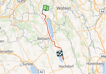
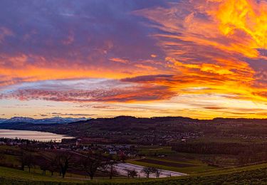
Randonnée Marche de 24 km à découvrir à Argovie, Bezirk Lenzburg, Hallwil. Cette randonnée est proposée par NicolasEngelke.
Description
Die Route ist einfach zu wandern und lädt im Sommer auf jeden Fall zum baden ein. Die Route kann bei jedem Wetter begangen werden. Hallwil und Baldegg sind dem ÖV sehr gut erreichbar.
Localisation
Pays :
Suisse
Région :
Argovie
Département/Province :
Bezirk Lenzburg
Commune :
Hallwil
Localité :
Unknown
Départ:(Dec)
Départ:(UTM)
437757 ; 5242122 (32T) N.
Commentaires
Randonnées à proximité
![Randonnée A pied Dintikon - Lenzburg - Ammerswil - Grossmoos - Photo](https://media.geolcdn.com/t/375/260/6790e93c-c3a1-4cf6-aebd-1bc9f55a4ed7.jpeg&format=jpg&maxdim=2)
![A pied A pied](https://static1.geolcdn.com/sitytour/trail-icons/100.png)
Lenzburg - Ammerswil - Grossmoos
A pied
Facile
Dintikon,
Argovie,
Bezirk Lenzburg,
Suisse
![](/images/other/stat-length.png)
7,1 km | 9,3 km-effort
2h 6min
![](https://static1.geolcdn.com/siteimages/upload/files/16400158638029165_repeat_loop_refresh_sync_direction_icon.png)
Non
![Randonnée A pied Fahrwangen - Schloss Hallwil - Fahrwangen - Photo](https://media.geolcdn.com/t/375/260/cd603db5-5f66-461f-910b-fd0f02992ef7.jpeg&format=jpg&maxdim=2)
![A pied A pied](https://static1.geolcdn.com/sitytour/trail-icons/100.png)
Schloss Hallwil - Fahrwangen
A pied
Facile
Fahrwangen,
Argovie,
Bezirk Lenzburg,
Suisse
![](/images/other/stat-length.png)
5,4 km | 6,5 km-effort
1h 28min
![](https://static1.geolcdn.com/siteimages/upload/files/16400158638029165_repeat_loop_refresh_sync_direction_icon.png)
Non
![Randonnée A pied Meisterschwanden - Schloss Hallwil - Strandbad Tennwil - Photo](https://media.geolcdn.com/t/375/260/03087f8b-5a76-47ca-95b5-ea400aea0764.jpeg&format=jpg&maxdim=2)
![A pied A pied](https://static1.geolcdn.com/sitytour/trail-icons/100.png)
Schloss Hallwil - Strandbad Tennwil
A pied
Facile
Meisterschwanden,
Argovie,
Bezirk Lenzburg,
Suisse
![](/images/other/stat-length.png)
3,2 km | 3,6 km-effort
48min
![](https://static1.geolcdn.com/siteimages/upload/files/16400158638029165_repeat_loop_refresh_sync_direction_icon.png)
Non
![Randonnée A pied Egliswil - Egliswil - Eichberg - Photo](https://media.geolcdn.com/t/375/260/9e1dac34-153e-49b6-aa12-68311b07facc.jpeg&format=jpg&maxdim=2)
![A pied A pied](https://static1.geolcdn.com/sitytour/trail-icons/100.png)
Egliswil - Eichberg
A pied
Facile
Egliswil,
Argovie,
Bezirk Lenzburg,
Suisse
![](/images/other/stat-length.png)
8,5 km | 12,5 km-effort
2h 50min
![](https://static1.geolcdn.com/siteimages/upload/files/16400158638029165_repeat_loop_refresh_sync_direction_icon.png)
Non
![Randonnée A pied Boniswil - Birrwil am See - Boniswil - Photo](https://media.geolcdn.com/t/375/260/97bafd55-a83c-4610-8425-46d77249dfd1.jpeg&format=jpg&maxdim=2)
![A pied A pied](https://static1.geolcdn.com/sitytour/trail-icons/100.png)
Birrwil am See - Boniswil
A pied
Facile
Boniswil,
Argovie,
Bezirk Lenzburg,
Suisse
![](/images/other/stat-length.png)
3,7 km | 4 km-effort
54min
![](https://static1.geolcdn.com/siteimages/upload/files/16400158638029165_repeat_loop_refresh_sync_direction_icon.png)
Non
![Randonnée A pied Seengen - Seon - Schloss Hallwil - Photo](https://media.geolcdn.com/t/375/260/d63a4bbc-be7b-49b7-b9bb-26806da55bbc.jpeg&format=jpg&maxdim=2)
![A pied A pied](https://static1.geolcdn.com/sitytour/trail-icons/100.png)
Seon - Schloss Hallwil
A pied
Facile
Seengen,
Argovie,
Bezirk Lenzburg,
Suisse
![](/images/other/stat-length.png)
5,5 km | 6,4 km-effort
1h 26min
![](https://static1.geolcdn.com/siteimages/upload/files/16400158638029165_repeat_loop_refresh_sync_direction_icon.png)
Non
![Randonnée A pied Seon - Gränichen - Breitenberg - Photo](https://media.geolcdn.com/t/375/260/40290f85-b244-496f-93be-defce90f143e.jpeg&format=jpg&maxdim=2)
![A pied A pied](https://static1.geolcdn.com/sitytour/trail-icons/100.png)
Gränichen - Breitenberg
A pied
Facile
Seon,
Argovie,
Bezirk Lenzburg,
Suisse
![](/images/other/stat-length.png)
5 km | 6,6 km-effort
1h 30min
![](https://static1.geolcdn.com/siteimages/upload/files/16400158638029165_repeat_loop_refresh_sync_direction_icon.png)
Non
![Randonnée A pied Leutwil - Oberkulm - Leutwil - Photo](https://media.geolcdn.com/t/375/260/97bafd55-a83c-4610-8425-46d77249dfd1.jpeg&format=jpg&maxdim=2)
![A pied A pied](https://static1.geolcdn.com/sitytour/trail-icons/100.png)
Oberkulm - Leutwil
A pied
Facile
Leutwil,
Argovie,
Bezirk Kulm,
Suisse
![](/images/other/stat-length.png)
5,7 km | 8,3 km-effort
1h 52min
![](https://static1.geolcdn.com/siteimages/upload/files/16400158638029165_repeat_loop_refresh_sync_direction_icon.png)
Non
![Randonnée A pied Leutwil - Leutwil - Unterkulm - Photo](https://media.geolcdn.com/t/375/260/77aa6f25-f16c-4954-9de7-bdee5276f091.jpeg&format=jpg&maxdim=2)
![A pied A pied](https://static1.geolcdn.com/sitytour/trail-icons/100.png)
Leutwil - Unterkulm
A pied
Facile
Leutwil,
Argovie,
Bezirk Kulm,
Suisse
![](/images/other/stat-length.png)
5,4 km | 7,5 km-effort
1h 42min
![](https://static1.geolcdn.com/siteimages/upload/files/16400158638029165_repeat_loop_refresh_sync_direction_icon.png)
Non