![](/images/other/stat-length.png)
![Randonnée Marche Kaiserstuhl - Rheinuferwanderung Kaiserstuhl — Eglisau — Rüedlingen - Photo](https://media.geolcdn.com/t/1900/400/ext.pjpeg?maxdim=2&url=https%3A%2F%2Fstatic1.geolcdn.com%2Fsiteimages%2Fupload%2Ffiles%2F1553511878bg_sport_marche.png)
Rheinuferwanderung Kaiserstuhl — Eglisau — Rüedlingen
NicolasEngelke
Utilisateur
![Longueur](/images/other/stat-length.png)
Longueur
17,5 km
![Altitude max](https://static1.geolcdn.com/siteimages/upload/files/1508320355ic_sort_altitude_max_24dp.png)
Altitude max
409 m
![Dénivelé positif](https://static1.geolcdn.com/siteimages/upload/files/1508320355ic_sort_den_pos_24dp.png)
Dénivelé positif
325 m
![Km-Effort](/images/other/stat-length.png)
Km-Effort
22 km
![Altitude min](https://static1.geolcdn.com/siteimages/upload/files/1508320355ic_sort_altitude_min_24dp.png)
Altitude min
330 m
![Dénivelé négatif](https://static1.geolcdn.com/siteimages/upload/files/1508320355ic_sort_den_neg_24dp.png)
Dénivelé négatif
328 m
![Boucle](https://static1.geolcdn.com/siteimages/upload/files/16400158638029165_repeat_loop_refresh_sync_direction_icon.png)
Boucle
Non
Date de création :
2016-01-03 00:00:00.0
Dernière modification :
2016-01-03 00:00:00.0
![Marche](https://static1.geolcdn.com/sitytour/trail-icons/101.png)
5h05
Difficulté : Facile
![Scannez ce code QR pour ouvrir la randonnée dans l'application SityTrail](https://capi.geolives.com/qq0zvz2zws4bq2lad0pu/sitytour/trails/509116/qr.png?size=200)
Application GPS de randonnée GRATUITE
À propos
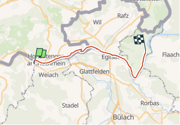
Randonnée Marche de 17,5 km à découvrir à Argovie, Bezirk Zurzach, Kaiserstuhl. Cette randonnée est proposée par NicolasEngelke.
Description
17.53 km
Distanz
Unsere Wanderzeit:
04:33:39 mit
00:28:23 Pause
17.5 km
489 m hoch
493 m runter
Gemäss Runtastic:
389 m hoch
392 m rutner
Localisation
Pays :
Suisse
Région :
Argovie
Département/Province :
Bezirk Zurzach
Commune :
Kaiserstuhl
Localité :
Unknown
Départ:(Dec)
Départ:(UTM)
456248 ; 5268303 (32T) N.
Commentaires
Randonnées à proximité
![Randonnée A pied Weiach - Weiach - Bachs - Photo](https://media.geolcdn.com/t/375/260/a534099c-c62d-4063-8981-0710a66cc224.jpeg&format=jpg&maxdim=2)
![A pied A pied](https://static1.geolcdn.com/sitytour/trail-icons/100.png)
Weiach - Bachs
A pied
Facile
Weiach,
Zurich,
Bezirk Dielsdorf,
Suisse
![](/images/other/stat-length.png)
5 km | 7,7 km-effort
1h 45min
![](https://static1.geolcdn.com/siteimages/upload/files/16400158638029165_repeat_loop_refresh_sync_direction_icon.png)
Non
![Randonnée A pied Stadel - Zweidlen Station - Neerach - Photo](https://media.geolcdn.com/t/375/260/1c18e405-0cb4-4a47-aced-f764d9fc6e74.jpeg&format=jpg&maxdim=2)
![A pied A pied](https://static1.geolcdn.com/sitytour/trail-icons/100.png)
Zweidlen Station - Neerach
A pied
Facile
Stadel,
Zurich,
Bezirk Dielsdorf,
Suisse
![](/images/other/stat-length.png)
4,9 km | 6,2 km-effort
1h 24min
![](https://static1.geolcdn.com/siteimages/upload/files/16400158638029165_repeat_loop_refresh_sync_direction_icon.png)
Non
![Randonnée A pied Glattfelden - Zweidlen Station - Weiach - Photo](https://media.geolcdn.com/t/375/260/8ae4039a-2dde-4469-898f-c221717596aa.jpeg&format=jpg&maxdim=2)
![A pied A pied](https://static1.geolcdn.com/sitytour/trail-icons/100.png)
Zweidlen Station - Weiach
A pied
Facile
Glattfelden,
Zurich,
Bezirk Bülach,
Suisse
![](/images/other/stat-length.png)
5,1 km | 7,5 km-effort
1h 41min
![](https://static1.geolcdn.com/siteimages/upload/files/16400158638029165_repeat_loop_refresh_sync_direction_icon.png)
Non
![Randonnée A pied Stadel - Windlach - Zweidlen - Photo](https://media.geolcdn.com/t/375/260/4ddf0d52-5fad-42aa-aa3c-5d576e6d7924.jpeg&format=jpg&maxdim=2)
![A pied A pied](https://static1.geolcdn.com/sitytour/trail-icons/100.png)
Windlach - Zweidlen
A pied
Facile
Stadel,
Zurich,
Bezirk Dielsdorf,
Suisse
![](/images/other/stat-length.png)
4,1 km | 5,7 km-effort
1h 17min
![](https://static1.geolcdn.com/siteimages/upload/files/16400158638029165_repeat_loop_refresh_sync_direction_icon.png)
Non
![Randonnée A pied Glattfelden - Zweidlen Station - Bülach - Photo](https://media.geolcdn.com/t/375/260/67170b21-8d7c-4a7e-8c61-2695dbca6845.jpeg&format=jpg&maxdim=2)
![A pied A pied](https://static1.geolcdn.com/sitytour/trail-icons/100.png)
Zweidlen Station - Bülach
A pied
Facile
Glattfelden,
Zurich,
Bezirk Bülach,
Suisse
![](/images/other/stat-length.png)
11,3 km | 14,5 km-effort
3h 17min
![](https://static1.geolcdn.com/siteimages/upload/files/16400158638029165_repeat_loop_refresh_sync_direction_icon.png)
Non
![Randonnée A pied Glattfelden - Zweidlen Station - Niederhöri - Photo](https://media.geolcdn.com/t/375/260/67170b21-8d7c-4a7e-8c61-2695dbca6845.jpeg&format=jpg&maxdim=2)
![A pied A pied](https://static1.geolcdn.com/sitytour/trail-icons/100.png)
Zweidlen Station - Niederhöri
A pied
Facile
Glattfelden,
Zurich,
Bezirk Bülach,
Suisse
![](/images/other/stat-length.png)
13 km | 15,4 km-effort
3h 30min
![](https://static1.geolcdn.com/siteimages/upload/files/16400158638029165_repeat_loop_refresh_sync_direction_icon.png)
Non
![Randonnée A pied Glattfelden - Rheinsfelden - Station Glattfelden - Photo](https://media.geolcdn.com/t/375/260/67170b21-8d7c-4a7e-8c61-2695dbca6845.jpeg&format=jpg&maxdim=2)
![A pied A pied](https://static1.geolcdn.com/sitytour/trail-icons/100.png)
Rheinsfelden - Station Glattfelden
A pied
Facile
Glattfelden,
Zurich,
Bezirk Bülach,
Suisse
![](/images/other/stat-length.png)
5,7 km | 6,9 km-effort
1h 33min
![](https://static1.geolcdn.com/siteimages/upload/files/16400158638029165_repeat_loop_refresh_sync_direction_icon.png)
Non
![Randonnée A pied Glattfelden - Rheinsfelden - Glattfelden - Photo](https://media.geolcdn.com/t/375/260/baa17ef4-1730-42d8-ae88-700f9027f126.jpeg&format=jpg&maxdim=2)
![A pied A pied](https://static1.geolcdn.com/sitytour/trail-icons/100.png)
Rheinsfelden - Glattfelden
A pied
Facile
Glattfelden,
Zurich,
Bezirk Bülach,
Suisse
![](/images/other/stat-length.png)
3,1 km | 4,1 km-effort
56min
![](https://static1.geolcdn.com/siteimages/upload/files/16400158638029165_repeat_loop_refresh_sync_direction_icon.png)
Non
![Randonnée A pied Fisibach - Fisibach- Bachs - Photo](https://media.geolcdn.com/t/375/260/ede589b8-109a-48d9-9149-5f1bf4e72135.jpeg&format=jpg&maxdim=2)
![A pied A pied](https://static1.geolcdn.com/sitytour/trail-icons/100.png)
Fisibach- Bachs
A pied
Facile
Fisibach,
Argovie,
Bezirk Zurzach,
Suisse
![](/images/other/stat-length.png)
6,7 km | 8,9 km-effort
2h 1min
![](https://static1.geolcdn.com/siteimages/upload/files/16400158638029165_repeat_loop_refresh_sync_direction_icon.png)
Non