![](/images/other/stat-length.png)
![Randonnée V.T.T. Estillac - demi boucle estillac - aubiac -moirax - Photo](https://media.geolcdn.com/t/1900/400/ext.pjpeg?maxdim=2&url=https%3A%2F%2Fstatic1.geolcdn.com%2Fsiteimages%2Fupload%2Ffiles%2F1524743154velo.jpg)
demi boucle estillac - aubiac -moirax
mapomme
Utilisateur
![Longueur](/images/other/stat-length.png)
Longueur
12,9 km
![Altitude max](https://static1.geolcdn.com/siteimages/upload/files/1508320355ic_sort_altitude_max_24dp.png)
Altitude max
176 m
![Dénivelé positif](https://static1.geolcdn.com/siteimages/upload/files/1508320355ic_sort_den_pos_24dp.png)
Dénivelé positif
374 m
![Km-Effort](/images/other/stat-length.png)
Km-Effort
17,6 km
![Altitude min](https://static1.geolcdn.com/siteimages/upload/files/1508320355ic_sort_altitude_min_24dp.png)
Altitude min
70 m
![Dénivelé négatif](https://static1.geolcdn.com/siteimages/upload/files/1508320355ic_sort_den_neg_24dp.png)
Dénivelé négatif
292 m
![Boucle](https://static1.geolcdn.com/siteimages/upload/files/16400158638029165_repeat_loop_refresh_sync_direction_icon.png)
Boucle
Non
Date de création :
2015-12-29 00:00:00.0
Dernière modification :
2015-12-29 00:00:00.0
![V.T.T.](https://static1.geolcdn.com/sitytour/trail-icons/202.png)
1h37
Difficulté : Facile
![Scannez ce code QR pour ouvrir la randonnée dans l'application SityTrail](https://capi.geolives.com/qq0zvz2zws4bq2lad0pu/sitytour/trails/507527/qr.png?size=200)
Application GPS de randonnée GRATUITE
À propos
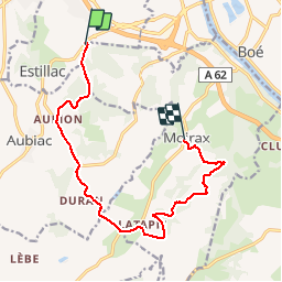
Randonnée V.T.T. de 12,9 km à découvrir à Nouvelle-Aquitaine, Lot-et-Garonne, Estillac. Cette randonnée est proposée par mapomme.
Description
Tres jolie demi boucle à compléter par autre demi boucle moirax-estillac. Attention petite erreur au niveau de trotte lapin. Tourner avant !
Localisation
Pays :
France
Région :
Nouvelle-Aquitaine
Département/Province :
Lot-et-Garonne
Commune :
Estillac
Localité :
Unknown
Départ:(Dec)
Départ:(UTM)
306334 ; 4892754 (31T) N.
Commentaires
Randonnées à proximité
![Randonnée Marche Moirax - Du Prieuré de Moirax à l'église de Sainte-Marie d'Aubiac - Pays de l'Agenais - Photo](https://media.geolcdn.com/t/375/260/ext.jpg?maxdim=2&url=https%3A%2F%2Fservices.sitytrail.com%2FGeolivesWS%2FDownloadMedia.ashx%3FTrailID%3D110648%26Media%3D6217_1.jpg)
![Marche Marche](https://static1.geolcdn.com/sitytour/trail-icons/101.png)
Du Prieuré de Moirax à l'église de Sainte-Marie d'Aubiac - Pays de l'Agenais
Marche
Difficile
(1)
Moirax,
Nouvelle-Aquitaine,
Lot-et-Garonne,
France
![](/images/other/stat-length.png)
15,2 km | 22 km-effort
4h 10min
![](https://static1.geolcdn.com/siteimages/upload/files/16400158638029165_repeat_loop_refresh_sync_direction_icon.png)
Oui
![Randonnée V.T.T. Moirax - Moirax, dans les coteaux de Marescot - Photo](https://media.geolcdn.com/t/375/260/ext.jpg?maxdim=2&url=https%3A%2F%2Fservices.sitytrail.com%2FGeolivesWS%2FDownloadMedia.ashx%3FTrailID%3D317190%26Media%3D16362_4.jpg)
![V.T.T. V.T.T.](https://static1.geolcdn.com/sitytour/trail-icons/202.png)
Moirax, dans les coteaux de Marescot
V.T.T.
Moyen
Moirax,
Nouvelle-Aquitaine,
Lot-et-Garonne,
France
![](/images/other/stat-length.png)
13,2 km | 17,7 km-effort
1h 40min
![](https://static1.geolcdn.com/siteimages/upload/files/16400158638029165_repeat_loop_refresh_sync_direction_icon.png)
Oui
![Randonnée Marche Moirax - Moirax, dans les coteaux de Marescot - Photo](https://media.geolcdn.com/t/375/260/ext.jpg?maxdim=2&url=https%3A%2F%2Fservices.sitytrail.com%2FGeolivesWS%2FDownloadMedia.ashx%3FTrailID%3D317189%26Media%3D16362_4.jpg)
![Marche Marche](https://static1.geolcdn.com/sitytour/trail-icons/101.png)
Moirax, dans les coteaux de Marescot
Marche
Difficile
(1)
Moirax,
Nouvelle-Aquitaine,
Lot-et-Garonne,
France
![](/images/other/stat-length.png)
13,2 km | 17,7 km-effort
3h 25min
![](https://static1.geolcdn.com/siteimages/upload/files/16400158638029165_repeat_loop_refresh_sync_direction_icon.png)
Oui
![Randonnée Marche Boé - Passeligne pélissier - Photo](https://media.geolcdn.com/t/375/260/ext.jpg?maxdim=2&url=https%3A%2F%2Fservices.sitytrail.com%2FGeolivesWS%2FDownloadMedia.ashx%3FTrailID%3D142015%26Media%3D20120725100922.jpg)
![Marche Marche](https://static1.geolcdn.com/sitytour/trail-icons/101.png)
Passeligne pélissier
Marche
Très facile
Boé,
Nouvelle-Aquitaine,
Lot-et-Garonne,
France
![](/images/other/stat-length.png)
5 km | 5,5 km-effort
1h 10min
![](https://static1.geolcdn.com/siteimages/upload/files/16400158638029165_repeat_loop_refresh_sync_direction_icon.png)
Oui
![Randonnée V.T.T. Estillac - Moirax - Photo](https://media.geolcdn.com/t/375/260/ext.jpg?maxdim=2&url=https%3A%2F%2Fservices.sitytrail.com%2FGeolivesWS%2FDownloadMedia.ashx%3FTrailID%3D101356%26Media%3D1027_4.jpg)
![V.T.T. V.T.T.](https://static1.geolcdn.com/sitytour/trail-icons/202.png)
Moirax
V.T.T.
Très difficile
(1)
Estillac,
Nouvelle-Aquitaine,
Lot-et-Garonne,
France
![](/images/other/stat-length.png)
42 km | 53 km-effort
3h 0min
![](https://static1.geolcdn.com/siteimages/upload/files/16400158638029165_repeat_loop_refresh_sync_direction_icon.png)
Oui
![Randonnée Cheval Moirax - Du Prieuré de Moirax à l'église de Sainte-Marie d'Aubiac - Pays de l'Agenais - Photo](https://media.geolcdn.com/t/375/260/ext.jpg?maxdim=2&url=https%3A%2F%2Fservices.sitytrail.com%2FGeolivesWS%2FDownloadMedia.ashx%3FTrailID%3D110650%26Media%3D6217_1.jpg)
![Cheval Cheval](https://static1.geolcdn.com/sitytour/trail-icons/300.png)
Du Prieuré de Moirax à l'église de Sainte-Marie d'Aubiac - Pays de l'Agenais
Cheval
Difficile
Moirax,
Nouvelle-Aquitaine,
Lot-et-Garonne,
France
![](/images/other/stat-length.png)
15,2 km | 22 km-effort
2h 40min
![](https://static1.geolcdn.com/siteimages/upload/files/16400158638029165_repeat_loop_refresh_sync_direction_icon.png)
Oui
![Randonnée V.T.T. Moirax - Du Prieuré de Moirax à l'église de Sainte-Marie d'Aubiac - Pays de l'Agenais - Photo](https://media.geolcdn.com/t/375/260/ext.jpg?maxdim=2&url=https%3A%2F%2Fservices.sitytrail.com%2FGeolivesWS%2FDownloadMedia.ashx%3FTrailID%3D110649%26Media%3D6217_1.jpg)
![V.T.T. V.T.T.](https://static1.geolcdn.com/sitytour/trail-icons/202.png)
Du Prieuré de Moirax à l'église de Sainte-Marie d'Aubiac - Pays de l'Agenais
V.T.T.
Difficile
Moirax,
Nouvelle-Aquitaine,
Lot-et-Garonne,
France
![](/images/other/stat-length.png)
15,2 km | 22 km-effort
2h 0min
![](https://static1.geolcdn.com/siteimages/upload/files/16400158638029165_repeat_loop_refresh_sync_direction_icon.png)
Oui
![Randonnée Marche Moirax - Moirax, sur la route des pèlerins de Saint-Jacques-de-Compostelle - Pays de l'Agenais - Photo](https://media.geolcdn.com/t/375/260/ext.jpg?maxdim=2&url=https%3A%2F%2Fservices.sitytrail.com%2FGeolivesWS%2FDownloadMedia.ashx%3FTrailID%3D110647%26Media%3D6216_1.jpg)
![Marche Marche](https://static1.geolcdn.com/sitytour/trail-icons/101.png)
Moirax, sur la route des pèlerins de Saint-Jacques-de-Compostelle - Pays de l...
Marche
Moyen
Moirax,
Nouvelle-Aquitaine,
Lot-et-Garonne,
France
![](/images/other/stat-length.png)
6,5 km | 8,7 km-effort
1h 45min
![](https://static1.geolcdn.com/siteimages/upload/files/16400158638029165_repeat_loop_refresh_sync_direction_icon.png)
Oui
![Randonnée Marche Le Passage - Le pont-canal, boulevard de l'eau - Pays de l'Agenais - Photo](https://media.geolcdn.com/t/375/260/ext.jpg?maxdim=2&url=https%3A%2F%2Fservices.sitytrail.com%2FGeolivesWS%2FDownloadMedia.ashx%3FTrailID%3D110643%26Media%3D6214_1.jpg)
![Marche Marche](https://static1.geolcdn.com/sitytour/trail-icons/101.png)
Le pont-canal, boulevard de l'eau - Pays de l'Agenais
Marche
Moyen
Le Passage,
Nouvelle-Aquitaine,
Lot-et-Garonne,
France
![](/images/other/stat-length.png)
7,1 km | 7,7 km-effort
2h 0min
![](https://static1.geolcdn.com/siteimages/upload/files/16400158638029165_repeat_loop_refresh_sync_direction_icon.png)
Oui