![](/images/other/stat-length.png)
![Randonnée Autre activité Larchant - PREPA M&R 170303 (ex.GLM160204) DJouanne - Photo](https://media.geolcdn.com/t/1900/400/ext.pjpeg?maxdim=2&url=https%3A%2F%2Fstatic1.geolcdn.com%2Fsiteimages%2Fupload%2Ffiles%2F1545311037marcheuse_200dpi.jpg)
PREPA M&R 170303 (ex.GLM160204) DJouanne
randodan
Utilisateur
![Longueur](/images/other/stat-length.png)
Longueur
12,4 km
![Altitude max](https://static1.geolcdn.com/siteimages/upload/files/1508320355ic_sort_altitude_max_24dp.png)
Altitude max
120 m
![Dénivelé positif](https://static1.geolcdn.com/siteimages/upload/files/1508320355ic_sort_den_pos_24dp.png)
Dénivelé positif
246 m
![Km-Effort](/images/other/stat-length.png)
Km-Effort
15,7 km
![Altitude min](https://static1.geolcdn.com/siteimages/upload/files/1508320355ic_sort_altitude_min_24dp.png)
Altitude min
68 m
![Dénivelé négatif](https://static1.geolcdn.com/siteimages/upload/files/1508320355ic_sort_den_neg_24dp.png)
Dénivelé négatif
247 m
![Boucle](https://static1.geolcdn.com/siteimages/upload/files/16400158638029165_repeat_loop_refresh_sync_direction_icon.png)
Boucle
Oui
Date de création :
2017-05-26 00:00:00.0
Dernière modification :
2017-05-26 00:00:00.0
![Autre activité](https://static1.geolcdn.com/sitytour/trail-icons/900.png)
2h34
Difficulté : Inconnu
![Scannez ce code QR pour ouvrir la randonnée dans l'application SityTrail](https://capi.geolives.com/qq0zvz2zws4bq2lad0pu/sitytour/trails/502133/qr.png?size=200)
Application GPS de randonnée GRATUITE
À propos
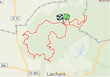
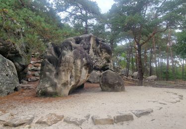
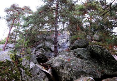
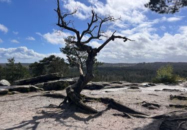
Randonnée Autre activité de 12,4 km à découvrir à Île-de-France, Seine-et-Marne, Larchant. Cette randonnée est proposée par randodan.
Description
PREPA Déné19/DameJouanne GLM
pour le 160211
Copie modifiée de 121031 :
prepa Déné.19 avec Mi Lo
Position des POI Maunoury corrigée suite à la RECO.<br>
Recorrigé pour F.StBernard et horaires pour M&R 170303 (dép.: 9h30).
Points d'intérêt
Localisation
Pays :
France
Région :
Île-de-France
Département/Province :
Seine-et-Marne
Commune :
Larchant
Localité :
Unknown
Départ:(Dec)
Départ:(UTM)
470311 ; 5350052 (31U) N.
Commentaires
Randonnées à proximité
![Randonnée Marche Recloses - Boucle recloses Nemours Grez/loing - Photo](https://media.geolcdn.com/t/375/260/191d15c7-1e16-40f7-89b9-dd7f9d0cddba.jpg&format=jpg&maxdim=2)
![Marche Marche](https://static1.geolcdn.com/sitytour/trail-icons/101.png)
Boucle recloses Nemours Grez/loing
Marche
Moyen
(1)
Recloses,
Île-de-France,
Seine-et-Marne,
France
![](/images/other/stat-length.png)
30 km | 34 km-effort
6h 20min
![](https://static1.geolcdn.com/siteimages/upload/files/16400158638029165_repeat_loop_refresh_sync_direction_icon.png)
Oui
![Randonnée Marche Larchant - Larchant la Féérique - Photo](https://media.geolcdn.com/t/375/260/6d6c76e3-bdd9-40d1-a9ae-e6ab32ef1956.jpg&format=jpg&maxdim=2)
![Marche Marche](https://static1.geolcdn.com/sitytour/trail-icons/101.png)
Larchant la Féérique
Marche
Moyen
Larchant,
Île-de-France,
Seine-et-Marne,
France
![](/images/other/stat-length.png)
19,6 km | 24 km-effort
5h 14min
![](https://static1.geolcdn.com/siteimages/upload/files/16400158638029165_repeat_loop_refresh_sync_direction_icon.png)
Oui
![Randonnée A pied Larchant - Sentier Denecourt-Colinet 19 - Photo](https://media.geolcdn.com/t/375/260/59338975-b7a3-4665-980b-9d3063da6c07.jpeg&format=jpg&maxdim=2)
![A pied A pied](https://static1.geolcdn.com/sitytour/trail-icons/100.png)
Sentier Denecourt-Colinet 19
A pied
Facile
Larchant,
Île-de-France,
Seine-et-Marne,
France
![](/images/other/stat-length.png)
9,7 km | 12,3 km-effort
2h 47min
![](https://static1.geolcdn.com/siteimages/upload/files/16400158638029165_repeat_loop_refresh_sync_direction_icon.png)
Oui
![Randonnée Marche Villiers-sous-Grez - Villiers sous grez / Larchant - Photo](https://media.geolcdn.com/t/375/260/2e824322-f7f9-4370-b291-7ab8bf6e7f9c.jpeg&format=jpg&maxdim=2)
![Marche Marche](https://static1.geolcdn.com/sitytour/trail-icons/101.png)
Villiers sous grez / Larchant
Marche
Très difficile
Villiers-sous-Grez,
Île-de-France,
Seine-et-Marne,
France
![](/images/other/stat-length.png)
24 km | 29 km-effort
5h 31min
![](https://static1.geolcdn.com/siteimages/upload/files/16400158638029165_repeat_loop_refresh_sync_direction_icon.png)
Oui
![Randonnée Marche Recloses - Recloses Ve120124 pm - Photo](https://media.geolcdn.com/t/375/260/ext.jpg?maxdim=2&url=https%3A%2F%2Fstatic1.geolcdn.com%2Fsiteimages%2Fupload%2Ffiles%2F1553511878bg_sport_marche.png)
![Marche Marche](https://static1.geolcdn.com/sitytour/trail-icons/101.png)
Recloses Ve120124 pm
Marche
Moyen
(1)
Recloses,
Île-de-France,
Seine-et-Marne,
France
![](/images/other/stat-length.png)
8,9 km | 10,5 km-effort
2h 23min
![](https://static1.geolcdn.com/siteimages/upload/files/16400158638029165_repeat_loop_refresh_sync_direction_icon.png)
Oui
![Randonnée Marche Recloses - Recloses ve 120124 am - Photo](https://media.geolcdn.com/t/375/260/ext.jpg?maxdim=2&url=https%3A%2F%2Fstatic1.geolcdn.com%2Fsiteimages%2Fupload%2Ffiles%2F1553511878bg_sport_marche.png)
![Marche Marche](https://static1.geolcdn.com/sitytour/trail-icons/101.png)
Recloses ve 120124 am
Marche
Moyen
(1)
Recloses,
Île-de-France,
Seine-et-Marne,
France
![](/images/other/stat-length.png)
10,8 km | 12,6 km-effort
2h 52min
![](https://static1.geolcdn.com/siteimages/upload/files/16400158638029165_repeat_loop_refresh_sync_direction_icon.png)
Oui
![Randonnée Marche Recloses - Recloses Ve 280423 SR30042323 PM10km - Photo](https://media.geolcdn.com/t/375/260/ext.jpg?maxdim=2&url=https%3A%2F%2Fstatic1.geolcdn.com%2Fsiteimages%2Fupload%2Ffiles%2F1553511878bg_sport_marche.png)
![Marche Marche](https://static1.geolcdn.com/sitytour/trail-icons/101.png)
Recloses Ve 280423 SR30042323 PM10km
Marche
Moyen
(1)
Recloses,
Île-de-France,
Seine-et-Marne,
France
![](/images/other/stat-length.png)
9,9 km | 11,9 km-effort
2h 42min
![](https://static1.geolcdn.com/siteimages/upload/files/16400158638029165_repeat_loop_refresh_sync_direction_icon.png)
Oui
![Randonnée Marche nordique Larchant - Dame Juane - Photo](https://media.geolcdn.com/t/375/260/bdae311e-408b-4eeb-853e-c7a245eb80a6.jpg&format=jpg&maxdim=2)
![Marche nordique Marche nordique](https://static1.geolcdn.com/sitytour/trail-icons/102.png)
Dame Juane
Marche nordique
Larchant,
Île-de-France,
Seine-et-Marne,
France
![](/images/other/stat-length.png)
22 km | 26 km-effort
3h 6min
![](https://static1.geolcdn.com/siteimages/upload/files/16400158638029165_repeat_loop_refresh_sync_direction_icon.png)
Non
![Randonnée Marche Recloses - Recloses Sentier Denecourt 20 - Photo](https://media.geolcdn.com/t/375/260/afdad310-6b1b-4619-b15a-3bf8585abd4e.jpg&format=jpg&maxdim=2)
![Marche Marche](https://static1.geolcdn.com/sitytour/trail-icons/101.png)
Recloses Sentier Denecourt 20
Marche
Moyen
Recloses,
Île-de-France,
Seine-et-Marne,
France
![](/images/other/stat-length.png)
6,4 km | 8 km-effort
2h 17min
![](https://static1.geolcdn.com/siteimages/upload/files/16400158638029165_repeat_loop_refresh_sync_direction_icon.png)
Oui