![](/images/other/stat-length.png)
![Randonnée Marche Augignac - Augignac Etangs Maison Neuve 12km - Photo](https://media.geolcdn.com/t/1900/400/ext.pjpeg?maxdim=2&url=https%3A%2F%2Fstatic1.geolcdn.com%2Fsiteimages%2Fupload%2Ffiles%2F1553511878bg_sport_marche.png)
Augignac Etangs Maison Neuve 12km
YV24
Utilisateur
![Longueur](/images/other/stat-length.png)
Longueur
11,4 km
![Altitude max](https://static1.geolcdn.com/siteimages/upload/files/1508320355ic_sort_altitude_max_24dp.png)
Altitude max
289 m
![Dénivelé positif](https://static1.geolcdn.com/siteimages/upload/files/1508320355ic_sort_den_pos_24dp.png)
Dénivelé positif
188 m
![Km-Effort](/images/other/stat-length.png)
Km-Effort
13,9 km
![Altitude min](https://static1.geolcdn.com/siteimages/upload/files/1508320355ic_sort_altitude_min_24dp.png)
Altitude min
205 m
![Dénivelé négatif](https://static1.geolcdn.com/siteimages/upload/files/1508320355ic_sort_den_neg_24dp.png)
Dénivelé négatif
188 m
![Boucle](https://static1.geolcdn.com/siteimages/upload/files/16400158638029165_repeat_loop_refresh_sync_direction_icon.png)
Boucle
Oui
Date de création :
2015-12-04 00:00:00.0
Dernière modification :
2015-12-04 00:00:00.0
![Marche](https://static1.geolcdn.com/sitytour/trail-icons/101.png)
3h04
Difficulté : Inconnu
![Scannez ce code QR pour ouvrir la randonnée dans l'application SityTrail](https://capi.geolives.com/qq0zvz2zws4bq2lad0pu/sitytour/trails/499637/qr.png?size=200)
Application GPS de randonnée GRATUITE
À propos
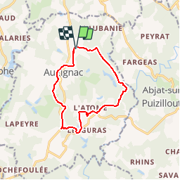
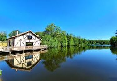
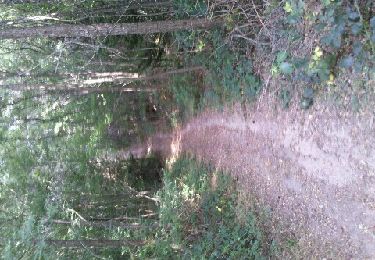
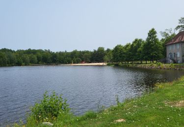
Randonnée Marche de 11,4 km à découvrir à Nouvelle-Aquitaine, Dordogne, Augignac. Cette randonnée est proposée par YV24.
Description
Variante du PDIPR des étangs. Au départ du parking de l'excellente ferme auberge de Maison Neuve. Circuit bien balisé, varié, avec très peu de route.
Localisation
Pays :
France
Région :
Nouvelle-Aquitaine
Département/Province :
Dordogne
Commune :
Augignac
Localité :
Unknown
Départ:(Dec)
Départ:(UTM)
321267 ; 5052151 (31T) N.
Commentaires
Randonnées à proximité
![Randonnée Marche Saint-Estèphe - Saint-Estephe par Piėgut - Photo](https://media.geolcdn.com/t/375/260/ext.jpg?maxdim=2&url=https%3A%2F%2Fmedia.geolcdn.com%2Ff%2Fc99618a3-f37b-47a0-bd7f-ee4865707faa.jpg)
![Marche Marche](https://static1.geolcdn.com/sitytour/trail-icons/101.png)
Saint-Estephe par Piėgut
Marche
Très facile
Saint-Estèphe,
Nouvelle-Aquitaine,
Dordogne,
France
![](/images/other/stat-length.png)
15 km | 0 m-effort
4h 13min
![](https://static1.geolcdn.com/siteimages/upload/files/16400158638029165_repeat_loop_refresh_sync_direction_icon.png)
Non
![Randonnée Marche Piégut-Pluviers - Piégut-Pluviers - Photo](https://media.geolcdn.com/t/375/260/ext.jpg?maxdim=2&url=https%3A%2F%2Fmedia.geolcdn.com%2Ff%2F02fbfc9d-86e2-4366-80b6-d8d62a04982e.jpg)
![Marche Marche](https://static1.geolcdn.com/sitytour/trail-icons/101.png)
Piégut-Pluviers
Marche
Piégut-Pluviers,
Nouvelle-Aquitaine,
Dordogne,
France
![](/images/other/stat-length.png)
4,7 km | 5,8 km-effort
1h 27min
![](https://static1.geolcdn.com/siteimages/upload/files/16400158638029165_repeat_loop_refresh_sync_direction_icon.png)
Non
![Randonnée Marche Saint-Estèphe - st estephe piegut - Photo](https://media.geolcdn.com/t/375/260/ext.jpg?maxdim=2&url=https%3A%2F%2Fmedia.geolcdn.com%2Ff%2F53805c82-2801-45d2-b33e-9467028aa66d.jpg)
![Marche Marche](https://static1.geolcdn.com/sitytour/trail-icons/101.png)
st estephe piegut
Marche
Très difficile
Saint-Estèphe,
Nouvelle-Aquitaine,
Dordogne,
France
![](/images/other/stat-length.png)
16,2 km | 20 km-effort
3h 15min
![](https://static1.geolcdn.com/siteimages/upload/files/16400158638029165_repeat_loop_refresh_sync_direction_icon.png)
Non
![Randonnée Marche Augignac - les chaufauds - Photo](https://media.geolcdn.com/t/375/260/ext.jpg?maxdim=2&url=https%3A%2F%2Fmedia.geolcdn.com%2Ff%2F3a9c9a2e-2591-499c-973e-55cd76e8d3b0.jpg)
![Marche Marche](https://static1.geolcdn.com/sitytour/trail-icons/101.png)
les chaufauds
Marche
Moyen
Augignac,
Nouvelle-Aquitaine,
Dordogne,
France
![](/images/other/stat-length.png)
8,7 km | 10,4 km-effort
2h 14min
![](https://static1.geolcdn.com/siteimages/upload/files/16400158638029165_repeat_loop_refresh_sync_direction_icon.png)
Oui
![Randonnée Marche Saint-Estèphe - Boucle Saint-Estèphe - Piégut - Photo](https://media.geolcdn.com/t/375/260/ext.jpg?maxdim=2&url=https%3A%2F%2Fmedia.geolcdn.com%2Ff%2F50193dbd-37ce-4585-9b76-a415caffc42d.jpg)
![Marche Marche](https://static1.geolcdn.com/sitytour/trail-icons/101.png)
Boucle Saint-Estèphe - Piégut
Marche
Difficile
Saint-Estèphe,
Nouvelle-Aquitaine,
Dordogne,
France
![](/images/other/stat-length.png)
13,1 km | 16,1 km-effort
3h 39min
![](https://static1.geolcdn.com/siteimages/upload/files/16400158638029165_repeat_loop_refresh_sync_direction_icon.png)
Oui
![Randonnée V.T.T. Augignac - Circuit_StEstephe_Bourdeix - Photo](https://media.geolcdn.com/t/375/260/ext.jpg?maxdim=2&url=https%3A%2F%2Fservices.sitytrail.com%2FGeolivesWS%2FDownloadMedia.ashx%3FTrailID%3D151844%26Media%3D20120905174028.jpeg)
![V.T.T. V.T.T.](https://static1.geolcdn.com/sitytour/trail-icons/202.png)
Circuit_StEstephe_Bourdeix
V.T.T.
Difficile
Augignac,
Nouvelle-Aquitaine,
Dordogne,
France
![](/images/other/stat-length.png)
27 km | 33 km-effort
2h 4min
![](https://static1.geolcdn.com/siteimages/upload/files/16400158638029165_repeat_loop_refresh_sync_direction_icon.png)
Oui
![Randonnée Marche Saint-Estèphe - St estephe - Photo](https://media.geolcdn.com/t/375/260/ext.jpg?maxdim=2&url=https%3A%2F%2Fmedia.geolcdn.com%2Ff%2F35eb7906-8cd6-4d01-8769-49908117716f.jpg)
![Marche Marche](https://static1.geolcdn.com/sitytour/trail-icons/101.png)
St estephe
Marche
Facile
Saint-Estèphe,
Nouvelle-Aquitaine,
Dordogne,
France
![](/images/other/stat-length.png)
3,1 km | 3,4 km-effort
1h 8min
![](https://static1.geolcdn.com/siteimages/upload/files/16400158638029165_repeat_loop_refresh_sync_direction_icon.png)
Oui
![Randonnée Marche Saint-Estèphe - De Saint-Estèphe à Piégut - Photo](https://media.geolcdn.com/t/375/260/ext.jpg?maxdim=2&url=https%3A%2F%2Fmedia.geolcdn.com%2Ff%2F00dcb190-9868-4105-a0cb-9bf1d8983eb6.jpg)
![Marche Marche](https://static1.geolcdn.com/sitytour/trail-icons/101.png)
De Saint-Estèphe à Piégut
Marche
Difficile
Saint-Estèphe,
Nouvelle-Aquitaine,
Dordogne,
France
![](/images/other/stat-length.png)
13,6 km | 16,6 km-effort
3h 46min
![](https://static1.geolcdn.com/siteimages/upload/files/16400158638029165_repeat_loop_refresh_sync_direction_icon.png)
Oui
![Randonnée Marche Abjat-sur-Bandiat - Abjat - Photo](https://media.geolcdn.com/t/375/260/ext.jpg?maxdim=2&url=https%3A%2F%2Fmedia.geolcdn.com%2Ff%2Fe614a19e-4b0d-4980-86eb-0a216014195a.jpg)
![Marche Marche](https://static1.geolcdn.com/sitytour/trail-icons/101.png)
Abjat
Marche
Très facile
Abjat-sur-Bandiat,
Nouvelle-Aquitaine,
Dordogne,
France
![](/images/other/stat-length.png)
5,5 km | 6,8 km-effort
2h 12min
![](https://static1.geolcdn.com/siteimages/upload/files/16400158638029165_repeat_loop_refresh_sync_direction_icon.png)
Non