Randonnée Marche Saint-Hubert - Awenne - Awenne (SH22) - Photo

Randonnées de la Grande Forêt de Saint-Hubert GUIDE+

© OpenStreetMap contributors
Longueur
Longueur
10,2 km
Altitude max
Altitude max
433 m
Dénivelé positif
Dénivelé positif
270 m
Km-Effort
Km-Effort  
13,8 km
Altitude min
Altitude min
275 m
Dénivelé négatif
Dénivelé négatif
268 m
Boucle
Boucle
Oui
Date de création :
2017-10-31 00:00:00.0
Dernière modification :
2017-10-31 00:00:00.0

(1 Avis)

Marche
Marche
2h54
Difficulté : Inconnu

Scannez ce code QR pour ouvrir la randonnée dans l'application SityTrail

Application GPS de randonnée GRATUITE

Logo SityTrail SityTrail

IGN / Instituts géographiques

Télécharger SityTrail sur l'App Store Télécharger SityTrail sur Google Play

Logo SityTrail SityTrail World

Le monde est à vous

Télécharger SityTrail sur l'App Store Télécharger SityTrail sur Google Play Télécharger SityTrail sur Huawei AppGallery

À propos

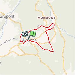
Randonnée Marche de 10,2 km à découvrir à Wallonie, Luxembourg, Saint-Hubert. Cette randonnée est proposée par La Grande Forêt de Saint-Hubert.

Description

Cette promenade vous permettra de découvrir le magnifique village d'Awenne, ainsi que la forêt et les prairies qui l'entourent.

Extrait de la carte de promenade « Au Pays de Saint-Hubert » (30 balades pédestres, 6 circuits VTT – carte topographique 1/25.000) disponible au Royal Syndicat d’Initiative de Saint-Hubert au prix de 8€.

Royal Syndicat d’Initiative de Saint-Hubert
Place du Marché, n°15
B-6870 SAINT-HUBERT
Tél.:  32 (0)61 61 30 10
Fax:  32 (0)61 61 54 44
rsi@saint-hubert-tourisme.be
www.rsi-sainthubert.be
facebook.com/rsisainthubert

Profil altimétrique

Photos

Points d'intérêt

Point d'intérêt Saint-Hubert - Départ - Photo
La Grande Forêt de Saint-Hubert
SAINT-HUBERT 

Localisation

Pays :
Belgique
Région :
Wallonie
Département/Province :
Luxembourg
Commune :
Saint-Hubert
Localité :
Awenne
Départ:(Dec)
Départ:(UTM)
664991 ; 5549427 (31U) N.

Commentaires

Veuillez vous connecter pour laisser un commentaire ou une note


manque les données kilométriques


Randonnées à proximité

Randonnée Marche Saint-Hubert - RB-Lu-26_Saint-Hubert_via-racc-1-et-2 - Photo
Marche
PRO

Marche

Très facile
(6)
Saint-Hubert, Wallonie, Luxembourg, Belgique
14,6 km | 19,5 km-effort
4h 15min
Oui
Randonnée Marche Saint-Hubert - Saint-Hubert - Les Gottes (SH02) - Photo
Marche
GUIDE+

Marche

Moyen
(15)
Saint-Hubert, Wallonie, Luxembourg, Belgique
6,9 km | 8,6 km-effort
1h 52min
Oui
Randonnée Marche Saint-Hubert - Mirwart_Vieux Moulin de Mirwart_Alternative Forêt (SH29 bis) - Photo
Marche
GUIDE+

Marche

Difficile
(12)
Saint-Hubert, Wallonie, Luxembourg, Belgique
10,8 km | 14,2 km-effort
3h 4min
Oui
Randonnée Marche Saint-Hubert - Marche ADEPS Arville - Photo
Marche
GUIDE
Bernard Gillet

Marche

Moyen
(1)
Saint-Hubert, Wallonie, Luxembourg, Belgique
10,2 km | 13,6 km-effort
2h 13min
Oui
Randonnée Marche Tellin - RL-GG-13_Grupont_Poix-Saint-Hubert - Photo
Marche
PRO

Marche

Très difficile
(2)
Tellin, Wallonie, Luxembourg, Belgique
26 km | 34 km-effort
7h 23min
Non
Randonnée Marche Tellin - Balade à Grupont - Photo
Marche
GUIDE
Desrumaux

Marche

Facile
(1)
Tellin, Wallonie, Luxembourg, Belgique
8,4 km | 11,9 km-effort
2h 33min
Oui
Randonnée Marche Tellin - Bure - Promenade des chapelles - Photo
Marche
GUIDE+

Marche

Facile
(1)
Tellin, Wallonie, Luxembourg, Belgique
4,5 km | 5,9 km-effort
1h 15min
Oui
Randonnée Marche Saint-Hubert - RB-Lu-26_Saint-Hubert - Photo
Marche
PRO

Marche

Très facile
(6)
Saint-Hubert, Wallonie, Luxembourg, Belgique
25 km | 33 km-effort
7h 2min
Oui
Randonnée Marche Saint-Hubert - RB-Lu-26_Saint-Hubert_via-racc-2 - Photo
Marche
PRO

Marche

Très facile
(2)
Saint-Hubert, Wallonie, Luxembourg, Belgique
23 km | 30 km-effort
6h 19min
Oui


Fermer
Mes abonnements