![](/images/other/stat-length.png)
![Randonnée Marche nordique Nivelles - Pain Blanc/Bois l'Hôpital/Monstreux et retour - Photo](https://media.geolcdn.com/t/1900/400/ext.pjpeg?maxdim=2&url=https%3A%2F%2Fstatic1.geolcdn.com%2Fsiteimages%2Fupload%2Ffiles%2F1545311037marcheuse_200dpi.jpg)
Pain Blanc/Bois l'Hôpital/Monstreux et retour
denissculier
Utilisateur
![Longueur](/images/other/stat-length.png)
Longueur
8,4 km
![Altitude max](https://static1.geolcdn.com/siteimages/upload/files/1508320355ic_sort_altitude_max_24dp.png)
Altitude max
115 m
![Dénivelé positif](https://static1.geolcdn.com/siteimages/upload/files/1508320355ic_sort_den_pos_24dp.png)
Dénivelé positif
96 m
![Km-Effort](/images/other/stat-length.png)
Km-Effort
9,6 km
![Altitude min](https://static1.geolcdn.com/siteimages/upload/files/1508320355ic_sort_altitude_min_24dp.png)
Altitude min
72 m
![Dénivelé négatif](https://static1.geolcdn.com/siteimages/upload/files/1508320355ic_sort_den_neg_24dp.png)
Dénivelé négatif
96 m
![Boucle](https://static1.geolcdn.com/siteimages/upload/files/16400158638029165_repeat_loop_refresh_sync_direction_icon.png)
Boucle
Oui
Date de création :
2016-04-23 00:00:00.0
Dernière modification :
2016-04-23 00:00:00.0
![Marche nordique](https://static1.geolcdn.com/sitytour/trail-icons/102.png)
2h05
Difficulté : Moyen
![Scannez ce code QR pour ouvrir la randonnée dans l'application SityTrail](https://capi.geolives.com/qq0zvz2zws4bq2lad0pu/sitytour/trails/484517/qr.png?size=200)
Application GPS de randonnée GRATUITE
À propos
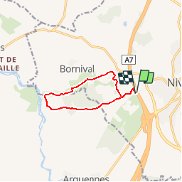
Randonnée Marche nordique de 8,4 km à découvrir à Wallonie, Brabant wallon, Nivelles. Cette randonnée est proposée par denissculier.
Description
Départ de Pain Blanc sous le pont de l'autoroute, vers le Neuf Bonniers puis traverser le Bois de l'Hôpital, le bois d'En-Bas, Au Cougnot vers l'église de Monsteux pour au travers des Wailles rejoindre Pain Blanc
Localisation
Pays :
Belgique
Région :
Wallonie
Département/Province :
Brabant wallon
Commune :
Nivelles
Localité :
Nivelles
Départ:(Dec)
Départ:(UTM)
591975 ; 5605505 (31U) N.
Commentaires
Randonnées à proximité
![Randonnée Marche Nivelles - RB-Bw-16_Monstreux_via-racc-1 - Photo](https://media.geolcdn.com/t/375/260/ext.jpg?maxdim=2&url=https%3A%2F%2Fservices.sitytrail.com%2FGeolivesWS%2FDownloadMedia.ashx%3FTrailID%3D354126%26Media%3Ddaedf7ee-f25e-4941-815b-dbbb8c629e47.jpg)
![Marche Marche](https://static1.geolcdn.com/sitytour/trail-icons/101.png)
RB-Bw-16_Monstreux_via-racc-1
Marche
Difficile
(11)
Nivelles,
Wallonie,
Brabant wallon,
Belgique
![](/images/other/stat-length.png)
12,8 km | 15 km-effort
3h 24min
![](https://static1.geolcdn.com/siteimages/upload/files/16400158638029165_repeat_loop_refresh_sync_direction_icon.png)
Oui
![Randonnée Marche Nivelles - RB-Bw-16_Monstreux_via-racc-2 - Photo](https://media.geolcdn.com/t/375/260/ext.jpg?maxdim=2&url=https%3A%2F%2Fservices.sitytrail.com%2FGeolivesWS%2FDownloadMedia.ashx%3FTrailID%3D221718%26Media%3Ddaedf7ee-f25e-4941-815b-dbbb8c629e47.jpg)
![Marche Marche](https://static1.geolcdn.com/sitytour/trail-icons/101.png)
RB-Bw-16_Monstreux_via-racc-2
Marche
Difficile
(9)
Nivelles,
Wallonie,
Brabant wallon,
Belgique
![](/images/other/stat-length.png)
16 km | 18,9 km-effort
4h 17min
![](https://static1.geolcdn.com/siteimages/upload/files/16400158638029165_repeat_loop_refresh_sync_direction_icon.png)
Oui
![Randonnée Marche Nivelles - RB-Bw-16_Monstreux - Photo](https://media.geolcdn.com/t/375/260/ext.jpg?maxdim=2&url=https%3A%2F%2Fservices.sitytrail.com%2FGeolivesWS%2FDownloadMedia.ashx%3FTrailID%3D179591%26Media%3D606a627b-9c11-4c95-a0ed-8415395e822e.jpg)
![Marche Marche](https://static1.geolcdn.com/sitytour/trail-icons/101.png)
RB-Bw-16_Monstreux
Marche
Très difficile
(11)
Nivelles,
Wallonie,
Brabant wallon,
Belgique
![](/images/other/stat-length.png)
20 km | 24 km-effort
5h 24min
![](https://static1.geolcdn.com/siteimages/upload/files/16400158638029165_repeat_loop_refresh_sync_direction_icon.png)
Oui
![Randonnée Marche Seneffe - De Arquennes à Monstreux par les vallées de la Thines et de la Samme - Photo](https://media.geolcdn.com/t/375/260/ext.jpg?maxdim=2&url=https%3A%2F%2Fservices.sitytrail.com%2FGeolivesWS%2FDownloadMedia.ashx%3FTrailID%3D127787%26Media%3D79b12576-f9f5-4657-a448-2793aa9c7eb2.JPG)
![Marche Marche](https://static1.geolcdn.com/sitytour/trail-icons/101.png)
De Arquennes à Monstreux par les vallées de la Thines et de la Samme
Marche
Facile
(6)
Seneffe,
Wallonie,
Hainaut,
Belgique
![](/images/other/stat-length.png)
13,7 km | 15,4 km-effort
3h 30min
![](https://static1.geolcdn.com/siteimages/upload/files/16400158638029165_repeat_loop_refresh_sync_direction_icon.png)
Oui
![Randonnée Marche Nivelles - Rando Bornival - Photo](https://media.geolcdn.com/t/375/260/ext.jpg?maxdim=2&url=https%3A%2F%2Fstatic1.geolcdn.com%2Fsiteimages%2Fupload%2Ffiles%2F1553511878bg_sport_marche.png)
![Marche Marche](https://static1.geolcdn.com/sitytour/trail-icons/101.png)
Rando Bornival
Marche
Facile
(5)
Nivelles,
Wallonie,
Brabant wallon,
Belgique
![](/images/other/stat-length.png)
13,2 km | 15,9 km-effort
3h 27min
![](https://static1.geolcdn.com/siteimages/upload/files/16400158638029165_repeat_loop_refresh_sync_direction_icon.png)
Oui
![Marche Marche](https://static1.geolcdn.com/sitytour/trail-icons/101.png)
BE-Bornival - Bois d'En-Bas - Ecluse 24 - Ancien canal
Marche
Moyen
(3)
Nivelles,
Wallonie,
Brabant wallon,
Belgique
![](/images/other/stat-length.png)
6,3 km | 7,5 km-effort
1h 41min
![](https://static1.geolcdn.com/siteimages/upload/files/16400158638029165_repeat_loop_refresh_sync_direction_icon.png)
Oui
![Randonnée Marche Seneffe - RB-Ha-05 - Feluy - Via allongement - Photo](https://media.geolcdn.com/t/375/260/ext.jpg?maxdim=2&url=https%3A%2F%2Fservices.sitytrail.com%2FGeolivesWS%2FDownloadMedia.ashx%3FTrailID%3D217842%26Media%3D989f0d00-0244-4058-a77e-e5e5f489d7be.jpg)
![Marche Marche](https://static1.geolcdn.com/sitytour/trail-icons/101.png)
RB-Ha-05 - Feluy - Via allongement
Marche
Très difficile
(4)
Seneffe,
Wallonie,
Hainaut,
Belgique
![](/images/other/stat-length.png)
23 km | 26 km-effort
5h 58min
![](https://static1.geolcdn.com/siteimages/upload/files/16400158638029165_repeat_loop_refresh_sync_direction_icon.png)
Oui
![Randonnée Marche Seneffe - RB-Ha-05 - Feluy - Photo](https://media.geolcdn.com/t/375/260/ext.jpg?maxdim=2&url=https%3A%2F%2Fservices.sitytrail.com%2FGeolivesWS%2FDownloadMedia.ashx%3FTrailID%3D179598%26Media%3D989f0d00-0244-4058-a77e-e5e5f489d7be.jpg)
![Marche Marche](https://static1.geolcdn.com/sitytour/trail-icons/101.png)
RB-Ha-05 - Feluy
Marche
Très difficile
(3)
Seneffe,
Wallonie,
Hainaut,
Belgique
![](/images/other/stat-length.png)
22 km | 25 km-effort
5h 39min
![](https://static1.geolcdn.com/siteimages/upload/files/16400158638029165_repeat_loop_refresh_sync_direction_icon.png)
Oui
![Randonnée Marche Seneffe - BE-Seneffe - Arquennes - Hameau Les Bois et l'ancien canal - Photo](https://media.geolcdn.com/t/375/260/eb61f70b-cfa0-40f0-88f8-9754f883475d.jpg&format=jpg&maxdim=2)
![Marche Marche](https://static1.geolcdn.com/sitytour/trail-icons/101.png)
BE-Seneffe - Arquennes - Hameau Les Bois et l'ancien canal
Marche
Moyen
(4)
Seneffe,
Wallonie,
Hainaut,
Belgique
![](/images/other/stat-length.png)
8,4 km | 9,5 km-effort
1h 52min
![](https://static1.geolcdn.com/siteimages/upload/files/16400158638029165_repeat_loop_refresh_sync_direction_icon.png)
Oui
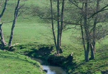
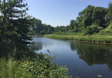
niveau accessible à tous, avec un peu de dénivelé sur de courtes distances. vues bien dégagées sur la campagne environnante. A faire par beau temps pour profiter du soleil