![](/images/other/stat-length.png)
![Randonnée V.T.T. Saint-Étienne-les-Orgues - Luberon - Espace FFC-VTT du Pays de Forcalquier Montagne de Lure - En duel avec Lure - Photo](https://media.geolcdn.com/t/1900/400/ext.pjpeg?maxdim=2&url=https%3A%2F%2Fstatic1.geolcdn.com%2Fsiteimages%2Fupload%2Ffiles%2F1524743154velo.jpg)
Luberon - Espace FFC-VTT du Pays de Forcalquier Montagne de Lure - En duel avec Lure
Vélo Loisir Provence
Randonnées de Vélo Loisir Provence GUIDE+
![Longueur](/images/other/stat-length.png)
Longueur
28 km
![Altitude max](https://static1.geolcdn.com/siteimages/upload/files/1508320355ic_sort_altitude_max_24dp.png)
Altitude max
1180 m
![Dénivelé positif](https://static1.geolcdn.com/siteimages/upload/files/1508320355ic_sort_den_pos_24dp.png)
Dénivelé positif
797 m
![Km-Effort](/images/other/stat-length.png)
Km-Effort
39 km
![Altitude min](https://static1.geolcdn.com/siteimages/upload/files/1508320355ic_sort_altitude_min_24dp.png)
Altitude min
562 m
![Dénivelé négatif](https://static1.geolcdn.com/siteimages/upload/files/1508320355ic_sort_den_neg_24dp.png)
Dénivelé négatif
791 m
![Boucle](https://static1.geolcdn.com/siteimages/upload/files/16400158638029165_repeat_loop_refresh_sync_direction_icon.png)
Boucle
Oui
Date de création :
2015-10-07 00:00:00.0
Dernière modification :
2015-10-07 00:00:00.0
![V.T.T.](https://static1.geolcdn.com/sitytour/trail-icons/202.png)
2h32
Difficulté : Difficile
![Scannez ce code QR pour ouvrir la randonnée dans l'application SityTrail](https://capi.geolives.com/qq0zvz2zws4bq2lad0pu/sitytour/trails/479644/qr.png?size=200)
Application GPS de randonnée GRATUITE
À propos
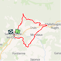
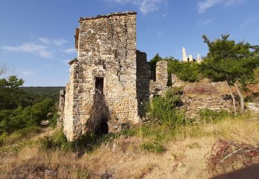
Randonnée V.T.T. de 28 km à découvrir à Provence-Alpes-Côte d'Azur, Alpes-de-Haute-Provence, Saint-Étienne-les-Orgues. Cette randonnée est proposée par Vélo Loisir Provence.
Description
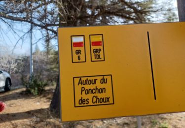
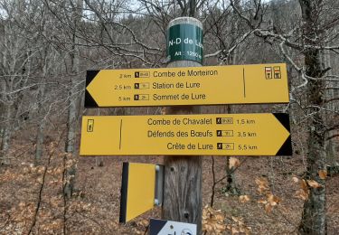
Parcours modifié sur 4 km en empruntant le parcours Enduro de Lure, merci de bien suivre le balisage en place qui est correct
Localisation
Pays :
France
Région :
Provence-Alpes-Côte d'Azur
Département/Province :
Alpes-de-Haute-Provence
Commune :
Saint-Étienne-les-Orgues
Localité :
Unknown
Départ:(Dec)
Départ:(UTM)
722848 ; 4880404 (31T) N.
Commentaires
Randonnées à proximité
![Randonnée Marche Cruis - CRUIS . L ESPINASSE . DEFEND DES BOEUF . JAS ROCHE . O S L - Photo](https://media.geolcdn.com/t/375/260/a0cf8023-8ba0-4cae-8b97-e7a5d91b64cb.jpg&format=jpg&maxdim=2)
![Marche Marche](https://static1.geolcdn.com/sitytour/trail-icons/101.png)
CRUIS . L ESPINASSE . DEFEND DES BOEUF . JAS ROCHE . O S L
Marche
Moyen
Cruis,
Provence-Alpes-Côte d'Azur,
Alpes-de-Haute-Provence,
France
![](/images/other/stat-length.png)
13 km | 19,9 km-effort
3h 29min
![](https://static1.geolcdn.com/siteimages/upload/files/16400158638029165_repeat_loop_refresh_sync_direction_icon.png)
Oui
![Randonnée Marche Saint-Étienne-les-Orgues - SAINT ETIENNE LES ORGUES . LE PONCHON DES CHOUX . 8 JAS O L - Photo](https://media.geolcdn.com/t/375/260/31b939da-7fe4-486b-a9fe-a6ccf57a27aa.jpg&format=jpg&maxdim=2)
![Marche Marche](https://static1.geolcdn.com/sitytour/trail-icons/101.png)
SAINT ETIENNE LES ORGUES . LE PONCHON DES CHOUX . 8 JAS O L
Marche
Moyen
Saint-Étienne-les-Orgues,
Provence-Alpes-Côte d'Azur,
Alpes-de-Haute-Provence,
France
![](/images/other/stat-length.png)
17,2 km | 26 km-effort
5h 14min
![](https://static1.geolcdn.com/siteimages/upload/files/16400158638029165_repeat_loop_refresh_sync_direction_icon.png)
Oui
![Randonnée Marche Saint-Étienne-les-Orgues - SAINT ÉTIENNE LES ORGUES . Notre Dame de Lure o l - Photo](https://media.geolcdn.com/t/375/260/9aa33c84-db1e-42b2-a1b2-7401b4684bec.jpg&format=jpg&maxdim=2)
![Marche Marche](https://static1.geolcdn.com/sitytour/trail-icons/101.png)
SAINT ÉTIENNE LES ORGUES . Notre Dame de Lure o l
Marche
Moyen
Saint-Étienne-les-Orgues,
Provence-Alpes-Côte d'Azur,
Alpes-de-Haute-Provence,
France
![](/images/other/stat-length.png)
16,3 km | 24 km-effort
4h 15min
![](https://static1.geolcdn.com/siteimages/upload/files/16400158638029165_repeat_loop_refresh_sync_direction_icon.png)
Oui
![Randonnée Marche Saint-Étienne-les-Orgues - MONTLAUX. Le Revest. La Blache . Vieux Montlaux o l s - Photo](https://media.geolcdn.com/t/375/260/067d0493-31a9-484f-b222-caf0ca30ade9.jpg&format=jpg&maxdim=2)
![Marche Marche](https://static1.geolcdn.com/sitytour/trail-icons/101.png)
MONTLAUX. Le Revest. La Blache . Vieux Montlaux o l s
Marche
Moyen
Saint-Étienne-les-Orgues,
Provence-Alpes-Côte d'Azur,
Alpes-de-Haute-Provence,
France
![](/images/other/stat-length.png)
17,3 km | 23 km-effort
4h 39min
![](https://static1.geolcdn.com/siteimages/upload/files/16400158638029165_repeat_loop_refresh_sync_direction_icon.png)
Oui
![Randonnée Marche Cruis - CRUIS . Jas Roche . Combe de Chevalet . ND de Lure o - Photo](https://media.geolcdn.com/t/375/260/f252a554-4783-452c-bf25-bee06d68bd1d.jpg&format=jpg&maxdim=2)
![Marche Marche](https://static1.geolcdn.com/sitytour/trail-icons/101.png)
CRUIS . Jas Roche . Combe de Chevalet . ND de Lure o
Marche
Facile
Cruis,
Provence-Alpes-Côte d'Azur,
Alpes-de-Haute-Provence,
France
![](/images/other/stat-length.png)
9 km | 13,8 km-effort
4h 0min
![](https://static1.geolcdn.com/siteimages/upload/files/16400158638029165_repeat_loop_refresh_sync_direction_icon.png)
Oui
![Randonnée Marche Saint-Étienne-les-Orgues - St Etienne les Orgues - La Blache - Photo](https://media.geolcdn.com/t/375/260/ext.jpg?maxdim=2&url=https%3A%2F%2Fstatic1.geolcdn.com%2Fsiteimages%2Fupload%2Ffiles%2F1553511878bg_sport_marche.png)
![Marche Marche](https://static1.geolcdn.com/sitytour/trail-icons/101.png)
St Etienne les Orgues - La Blache
Marche
Moyen
(1)
Saint-Étienne-les-Orgues,
Provence-Alpes-Côte d'Azur,
Alpes-de-Haute-Provence,
France
![](/images/other/stat-length.png)
14,8 km | 19,3 km-effort
4h 16min
![](https://static1.geolcdn.com/siteimages/upload/files/16400158638029165_repeat_loop_refresh_sync_direction_icon.png)
Oui
![Randonnée Marche Lardiers - lardiers.le jas du grand chêne - Photo](https://media.geolcdn.com/t/375/260/a20a7e86-9075-402d-9419-9da41fb93e79.jpg&format=jpg&maxdim=2)
![Marche Marche](https://static1.geolcdn.com/sitytour/trail-icons/101.png)
lardiers.le jas du grand chêne
Marche
Moyen
Lardiers,
Provence-Alpes-Côte d'Azur,
Alpes-de-Haute-Provence,
France
![](/images/other/stat-length.png)
9,1 km | 13,6 km-effort
3h 30min
![](https://static1.geolcdn.com/siteimages/upload/files/16400158638029165_repeat_loop_refresh_sync_direction_icon.png)
Oui
![Randonnée Marche Lardiers - lardiers. du grand chêne à la bergerie inconnue - Photo](https://media.geolcdn.com/t/375/260/e56507b0-667f-45e8-a4de-a1d444c78beb.jpg&format=jpg&maxdim=2)
![Marche Marche](https://static1.geolcdn.com/sitytour/trail-icons/101.png)
lardiers. du grand chêne à la bergerie inconnue
Marche
Moyen
Lardiers,
Provence-Alpes-Côte d'Azur,
Alpes-de-Haute-Provence,
France
![](/images/other/stat-length.png)
10,1 km | 15,9 km-effort
4h 2min
![](https://static1.geolcdn.com/siteimages/upload/files/16400158638029165_repeat_loop_refresh_sync_direction_icon.png)
Oui
![Randonnée Marche Montlaux - MONTLAUX. LES SOURCES DU LAUZON .O L M - Photo](https://media.geolcdn.com/t/375/260/f4854e53-edc8-45e8-9b45-a70e3872e836.jpg&format=jpg&maxdim=2)
![Marche Marche](https://static1.geolcdn.com/sitytour/trail-icons/101.png)
MONTLAUX. LES SOURCES DU LAUZON .O L M
Marche
Moyen
Montlaux,
Provence-Alpes-Côte d'Azur,
Alpes-de-Haute-Provence,
France
![](/images/other/stat-length.png)
8,5 km | 10,7 km-effort
2h 33min
![](https://static1.geolcdn.com/siteimages/upload/files/16400158638029165_repeat_loop_refresh_sync_direction_icon.png)
Oui