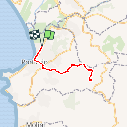
![](/images/other/stat-length.png)
![Randonnée Marche Grosseto-Prugna - Corse-150922 - MareMonti-TourFrassu - Photo](https://media.geolcdn.com/t/1900/400/ext.pjpeg?maxdim=2&url=https%3A%2F%2Fservices.sitytrail.com%2FGeolivesWS%2FDownloadMedia.ashx%3FTrailID%3D475893%26Media%3D8b68c219-8a6e-4d7b-ae9b-117db4d3c025.jpg)
Corse-150922 - MareMonti-TourFrassu
randodan
Utilisateur
![Longueur](/images/other/stat-length.png)
![Altitude max](https://static1.geolcdn.com/siteimages/upload/files/1508320355ic_sort_altitude_max_24dp.png)
![Dénivelé positif](https://static1.geolcdn.com/siteimages/upload/files/1508320355ic_sort_den_pos_24dp.png)
![Km-Effort](/images/other/stat-length.png)
![Altitude min](https://static1.geolcdn.com/siteimages/upload/files/1508320355ic_sort_altitude_min_24dp.png)
![Dénivelé négatif](https://static1.geolcdn.com/siteimages/upload/files/1508320355ic_sort_den_neg_24dp.png)
![Boucle](https://static1.geolcdn.com/siteimages/upload/files/16400158638029165_repeat_loop_refresh_sync_direction_icon.png)
![Marche](https://static1.geolcdn.com/sitytour/trail-icons/101.png)
4h20
Difficulté : Facile
![Scannez ce code QR pour ouvrir la randonnée dans l'application SityTrail](https://capi.geolives.com/qq0zvz2zws4bq2lad0pu/sitytour/trails/475893/qr.png?size=200)
Application GPS de randonnée GRATUITE
À propos
Randonnée Marche de 13,3 km à découvrir à Corse, Corse-du-Sud, Grosseto-Prugna. Cette randonnée est proposée par randodan.
Description
2015 - Corse, Marinca Porticcio<br>
- 22 sep. - Mare e Monti Sud - Tour Frassu -<br>
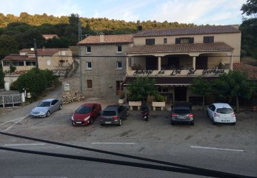
Départ de la CCAS Porticcio à 14h . Le sentier prévu est en fait un tronçon commun Mare e Monti Sud et Mare a Mare Centre.<br>
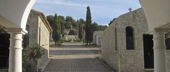
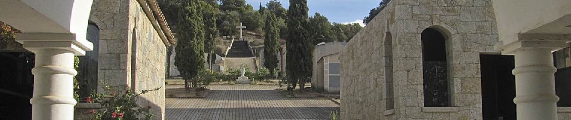
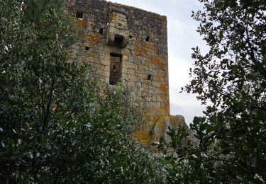
Béton, béton jusqu'au cimetière (très beau !) . Juste après, notre 1ère grimpette du séjour, pour nous mettre en jambes . La Tour de Frassu, c'est le GPS qui nous l'indique car nous allions passer à proximité sans la voir . Un tout petit sentier conduit à la Tour en ruine (350 m) en propriété privée.<br>
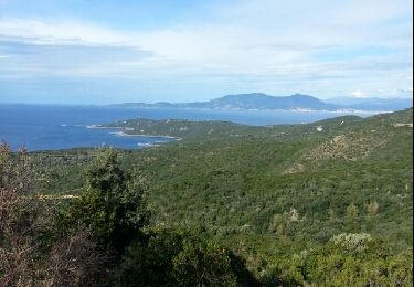
Dans l'intention de faire une boucle, continuons jusqu'à toucher la route de Zizoli, puis lâchons le Mare a Mare pour rentrer par des sentiers qu'il nous reste à découvrir . Malheureusement, n'ayant pas du tout envie de nous faire dévorer par des chiens furieux (propriété privée ??), nous nous résolvons à faire demi-tour et revenons par le même chemin.<br>
Retour à la CCAS à 18h20.
Localisation
Commentaires
Randonnées à proximité
![Randonnée Marche Grosseto-Prugna - Porticcio - Bisiano - 14 km - Photo](https://media.geolcdn.com/t/375/260/ext.jpg?maxdim=2&url=https%3A%2F%2Fstatic1.geolcdn.com%2Fsiteimages%2Fupload%2Ffiles%2F1553511878bg_sport_marche.png)
![Marche Marche](https://static1.geolcdn.com/sitytour/trail-icons/101.png)
Marche
![](/images/other/stat-length.png)
![](https://static1.geolcdn.com/siteimages/upload/files/16400158638029165_repeat_loop_refresh_sync_direction_icon.png)
![Randonnée Course à pied Ajaccio - antennes - Photo](https://media.geolcdn.com/t/375/260/ext.jpg?maxdim=2&url=https%3A%2F%2Fstatic1.geolcdn.com%2Fsiteimages%2Fupload%2Ffiles%2F1524743154running.jpg)
![Course à pied Course à pied](https://static1.geolcdn.com/sitytour/trail-icons/103.png)
Course à pied
![](/images/other/stat-length.png)
![](https://static1.geolcdn.com/siteimages/upload/files/16400158638029165_repeat_loop_refresh_sync_direction_icon.png)
![Randonnée Vélo Ajaccio - Boucle lac de Tolla - Photo](https://media.geolcdn.com/t/375/260/ext.jpg?maxdim=2&url=https%3A%2F%2Fstatic1.geolcdn.com%2Fsiteimages%2Fupload%2Ffiles%2F1524743154velo.jpg)
![Vélo Vélo](https://static1.geolcdn.com/sitytour/trail-icons/200.png)
Vélo
![](/images/other/stat-length.png)
![](https://static1.geolcdn.com/siteimages/upload/files/16400158638029165_repeat_loop_refresh_sync_direction_icon.png)
![Randonnée Vélo Ajaccio - Boucle Massif du Gozzi - Photo](https://media.geolcdn.com/t/375/260/ext.jpg?maxdim=2&url=https%3A%2F%2Fstatic1.geolcdn.com%2Fsiteimages%2Fupload%2Ffiles%2F1524743154velo.jpg)
![Vélo Vélo](https://static1.geolcdn.com/sitytour/trail-icons/200.png)
Vélo
![](/images/other/stat-length.png)
![](https://static1.geolcdn.com/siteimages/upload/files/16400158638029165_repeat_loop_refresh_sync_direction_icon.png)
![Randonnée Marche Grosseto-Prugna - frassu - Photo](https://media.geolcdn.com/t/375/260/5b18b434-ac9a-4a5d-8336-ad4cffecde08.jpg&format=jpg&maxdim=2)
![Marche Marche](https://static1.geolcdn.com/sitytour/trail-icons/101.png)
![Randonnée Marche Ajaccio - Ma Mare a Mare centre étape 1: Aéroport d'Ajaccio vers le col St Georges - Photo](https://media.geolcdn.com/t/375/260/ext.jpg?maxdim=2&url=https%3A%2F%2Fservices.sitytrail.com%2FGeolivesWS%2FDownloadMedia.ashx%3FTrailID%3D338503%26Media%3D0b6a5268-b9ba-4761-8e4c-a3506ec17191.JPG)
![Marche Marche](https://static1.geolcdn.com/sitytour/trail-icons/101.png)
Marche
![](/images/other/stat-length.png)
![](https://static1.geolcdn.com/siteimages/upload/files/16400158638029165_repeat_loop_refresh_sync_direction_icon.png)
![Randonnée Marche Grosseto-Prugna - mare_è_monti_sud - Photo](https://media.geolcdn.com/t/375/260/e2001393-b22b-47c3-bf0f-73af7e69f8f1.webp&format=jpg&maxdim=2)
![Marche Marche](https://static1.geolcdn.com/sitytour/trail-icons/101.png)
Marche
![](/images/other/stat-length.png)
![](https://static1.geolcdn.com/siteimages/upload/files/16400158638029165_repeat_loop_refresh_sync_direction_icon.png)
![Randonnée Vélo Ajaccio - Circuit Ajaccio sud 1 - Photo](https://media.geolcdn.com/t/375/260/ext.jpg?maxdim=2&url=https%3A%2F%2Fservices.sitytrail.com%2FGeolivesWS%2FDownloadMedia.ashx%3FTrailID%3D233555%26Media%3Dfix__20131119124701.jpg)
![Vélo Vélo](https://static1.geolcdn.com/sitytour/trail-icons/200.png)
Vélo
![](/images/other/stat-length.png)
![](https://static1.geolcdn.com/siteimages/upload/files/16400158638029165_repeat_loop_refresh_sync_direction_icon.png)
![Randonnée Marche Grosseto-Prugna - Mare e Monti Sud - De Porticcio à Bisinao - Photo](https://media.geolcdn.com/t/375/260/ext.jpg?maxdim=2&url=https%3A%2F%2Fservices.sitytrail.com%2FGeolivesWS%2FDownloadMedia.ashx%3FTrailID%3D109317%26Media%3D3572_1.jpg)
![Marche Marche](https://static1.geolcdn.com/sitytour/trail-icons/101.png)
Marche
![](/images/other/stat-length.png)
![](https://static1.geolcdn.com/siteimages/upload/files/16400158638029165_repeat_loop_refresh_sync_direction_icon.png)