![](/images/other/stat-length.png)
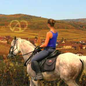
![Randonnée Randonnée équestre Schleithal - Circuit VDN Schleithal MerkwillerPechelbronn - Photo](https://media.geolcdn.com/t/1900/400/553ea2f7-13a9-4706-94e9-23ae7277b6fd.jpg&format=pjpeg&maxdim=2)
Circuit VDN Schleithal MerkwillerPechelbronn
Tourisme Equestre Alsace
Promouvoir le Tourisme Equestre en Alsace GUIDE+
![Longueur](/images/other/stat-length.png)
Longueur
29 km
![Altitude max](https://static1.geolcdn.com/siteimages/upload/files/1508320355ic_sort_altitude_max_24dp.png)
Altitude max
222 m
![Dénivelé positif](https://static1.geolcdn.com/siteimages/upload/files/1508320355ic_sort_den_pos_24dp.png)
Dénivelé positif
378 m
![Km-Effort](/images/other/stat-length.png)
Km-Effort
34 km
![Altitude min](https://static1.geolcdn.com/siteimages/upload/files/1508320355ic_sort_altitude_min_24dp.png)
Altitude min
147 m
![Dénivelé négatif](https://static1.geolcdn.com/siteimages/upload/files/1508320355ic_sort_den_neg_24dp.png)
Dénivelé négatif
350 m
![Boucle](https://static1.geolcdn.com/siteimages/upload/files/16400158638029165_repeat_loop_refresh_sync_direction_icon.png)
Boucle
Non
Date de création :
2015-09-24 00:00:00.0
Dernière modification :
2019-01-05 18:16:06.063
![Randonnée équestre](https://static1.geolcdn.com/sitytour/trail-icons/301.png)
4h15
Difficulté : Difficile
![Scannez ce code QR pour ouvrir la randonnée dans l'application SityTrail](https://capi.geolives.com/qq0zvz2zws4bq2lad0pu/sitytour/trails/474958/qr.png?size=200)
Application GPS de randonnée GRATUITE
À propos
Randonnée Randonnée équestre de 29 km à découvrir à Grand Est, Bas-Rhin, Schleithal. Cette randonnée est proposée par Tourisme Equestre Alsace.
Localisation
Pays :
France
Région :
Grand Est
Département/Province :
Bas-Rhin
Commune :
Schleithal
Localité :
Unknown
Départ:(Dec)
Départ:(UTM)
430667 ; 5426347 (32U) N.
Commentaires
Randonnées à proximité
![Randonnée Randonnée équestre Schleithal - Circuit Palatinat Schleithal Silz - Photo](https://media.geolcdn.com/t/375/260/63aab5f9-081c-4bb1-af42-9fe0f7d41772.jpg&format=jpg&maxdim=2)
![Randonnée équestre Randonnée équestre](https://static1.geolcdn.com/sitytour/trail-icons/301.png)
Circuit Palatinat Schleithal Silz
Randonnée équestre
Moyen
Schleithal,
Grand Est,
Bas-Rhin,
France
![](/images/other/stat-length.png)
32 km | 42 km-effort
5h 29min
![](https://static1.geolcdn.com/siteimages/upload/files/16400158638029165_repeat_loop_refresh_sync_direction_icon.png)
Non
![Randonnée Randonnée équestre Schleithal - Circuit Palatinat Lampertsloch Schleithal - Photo](https://media.geolcdn.com/t/375/260/83b80ba9-c4c7-48c6-9d18-e186493a5565.jpg&format=jpg&maxdim=2)
![Randonnée équestre Randonnée équestre](https://static1.geolcdn.com/sitytour/trail-icons/301.png)
Circuit Palatinat Lampertsloch Schleithal
Randonnée équestre
Difficile
Schleithal,
Grand Est,
Bas-Rhin,
France
![](/images/other/stat-length.png)
25 km | 31 km-effort
4h 5min
![](https://static1.geolcdn.com/siteimages/upload/files/16400158638029165_repeat_loop_refresh_sync_direction_icon.png)
Non
![Randonnée Randonnée équestre Schleithal - Circuit VDN Schleithal Oberotterbach - Photo](https://media.geolcdn.com/t/375/260/f828899d-09b7-4f33-a54c-e2b8f82b0449.jpg&format=jpg&maxdim=2)
![Randonnée équestre Randonnée équestre](https://static1.geolcdn.com/sitytour/trail-icons/301.png)
Circuit VDN Schleithal Oberotterbach
Randonnée équestre
Moyen
Schleithal,
Grand Est,
Bas-Rhin,
France
![](/images/other/stat-length.png)
25 km | 29 km-effort
3h 41min
![](https://static1.geolcdn.com/siteimages/upload/files/16400158638029165_repeat_loop_refresh_sync_direction_icon.png)
Non
![Randonnée Randonnée équestre Schleithal - Circuit VDN Schleithal Neewiller - Photo](https://media.geolcdn.com/t/375/260/87350cec-7749-43f8-8f8f-0d76c8b47bd6.jpg&format=jpg&maxdim=2)
![Randonnée équestre Randonnée équestre](https://static1.geolcdn.com/sitytour/trail-icons/301.png)
Circuit VDN Schleithal Neewiller
Randonnée équestre
Facile
Schleithal,
Grand Est,
Bas-Rhin,
France
![](/images/other/stat-length.png)
14,5 km | 16,4 km-effort
2h 5min
![](https://static1.geolcdn.com/siteimages/upload/files/16400158638029165_repeat_loop_refresh_sync_direction_icon.png)
Non
![Randonnée Randonnée équestre Schleithal - Circuit VDN Schleithal Lembach - Photo](https://media.geolcdn.com/t/375/260/8dbc7eb3-2a1c-4885-9825-384e507521dd.jpg&format=jpg&maxdim=2)
![Randonnée équestre Randonnée équestre](https://static1.geolcdn.com/sitytour/trail-icons/301.png)
Circuit VDN Schleithal Lembach
Randonnée équestre
Difficile
Schleithal,
Grand Est,
Bas-Rhin,
France
![](/images/other/stat-length.png)
31 km | 39 km-effort
4h 58min
![](https://static1.geolcdn.com/siteimages/upload/files/16400158638029165_repeat_loop_refresh_sync_direction_icon.png)
Non
![Randonnée Cheval Seebach - seebach - schoenenbourg -bremmelbach-steinseltz -seebach - Photo](https://media.geolcdn.com/t/375/260/ext.jpg?maxdim=2&url=https%3A%2F%2Fstatic1.geolcdn.com%2Fsiteimages%2Fupload%2Ffiles%2F1524743154cheval.jpg)
![Cheval Cheval](https://static1.geolcdn.com/sitytour/trail-icons/300.png)
seebach - schoenenbourg -bremmelbach-steinseltz -seebach
Cheval
Moyen
Seebach,
Grand Est,
Bas-Rhin,
France
![](/images/other/stat-length.png)
30 km | 36 km-effort
5h 46min
![](https://static1.geolcdn.com/siteimages/upload/files/16400158638029165_repeat_loop_refresh_sync_direction_icon.png)
Oui
![Randonnée Randonnée équestre Schleithal - 5 Germanshof Schleithal - Photo](https://media.geolcdn.com/t/375/260/ext.jpg?maxdim=2&url=https%3A%2F%2Fstatic1.geolcdn.com%2Fsiteimages%2Fupload%2Ffiles%2F1524743154cheval.jpg)
![Randonnée équestre Randonnée équestre](https://static1.geolcdn.com/sitytour/trail-icons/301.png)
5 Germanshof Schleithal
Randonnée équestre
Moyen
Schleithal,
Grand Est,
Bas-Rhin,
France
![](/images/other/stat-length.png)
20 km | 24 km-effort
3h 12min
![](https://static1.geolcdn.com/siteimages/upload/files/16400158638029165_repeat_loop_refresh_sync_direction_icon.png)
Non
![Randonnée Randonnée équestre Schleithal - Schleithal 27 Altenstadt Kakteenland - Photo](https://media.geolcdn.com/t/375/260/ext.jpg?maxdim=2&url=https%3A%2F%2Fstatic1.geolcdn.com%2Fsiteimages%2Fupload%2Ffiles%2F1524743154cheval.jpg)
![Randonnée équestre Randonnée équestre](https://static1.geolcdn.com/sitytour/trail-icons/301.png)
Schleithal 27 Altenstadt Kakteenland
Randonnée équestre
Moyen
Schleithal,
Grand Est,
Bas-Rhin,
France
![](/images/other/stat-length.png)
27 km | 30 km-effort
3h 50min
![](https://static1.geolcdn.com/siteimages/upload/files/16400158638029165_repeat_loop_refresh_sync_direction_icon.png)
Oui
![Randonnée Randonnée équestre Schleithal - Schleithal Ferme Bleue - Bienwaldtour nach Kapsweyer - Photo](https://media.geolcdn.com/t/375/260/ext.jpg?maxdim=2&url=https%3A%2F%2Fstatic1.geolcdn.com%2Fsiteimages%2Fupload%2Ffiles%2F1524743154cheval.jpg)
![Randonnée équestre Randonnée équestre](https://static1.geolcdn.com/sitytour/trail-icons/301.png)
Schleithal Ferme Bleue - Bienwaldtour nach Kapsweyer
Randonnée équestre
Moyen
Schleithal,
Grand Est,
Bas-Rhin,
France
![](/images/other/stat-length.png)
26 km | 29 km-effort
3h 42min
![](https://static1.geolcdn.com/siteimages/upload/files/16400158638029165_repeat_loop_refresh_sync_direction_icon.png)
Oui