Randonnée Course à pied La Bâtie-Rolland - la Batie - la bégude - Photo
 morgan.moret
morgan.moret

Utilisateur

© OpenStreetMap contributors
Longueur
Longueur
7,9 km
Altitude max
Altitude max
225 m
Dénivelé positif
Dénivelé positif
102 m
Km-Effort
Km-Effort  
9,1 km
Altitude min
Altitude min
154 m
Dénivelé négatif
Dénivelé négatif
42 m
Boucle
Boucle
Non
Date de création :
2015-09-15 00:00:00.0
Dernière modification :
2015-09-15 00:00:00.0

(1 Avis)

Course à pied
Course à pied
50m
Difficulté : Facile

Scannez ce code QR pour ouvrir la randonnée dans l'application SityTrail

Application GPS de randonnée GRATUITE

Logo SityTrail SityTrail

IGN / Instituts géographiques

Télécharger SityTrail sur l'App Store Télécharger SityTrail sur Google Play

Logo SityTrail SityTrail World

Le monde est à vous

Télécharger SityTrail sur l'App Store Télécharger SityTrail sur Google Play Télécharger SityTrail sur Huawei AppGallery

À propos

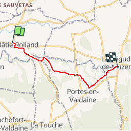
Randonnée Course à pied de 7,9 km à découvrir à Auvergne-Rhône-Alpes, Drôme, La Bâtie-Rolland. Cette randonnée est proposée par morgan.moret.

Description

Départ du contrôle technique et retour à la bégude à travers champs et vignes.

Profil altimétrique

Localisation

Pays :
France
Région :
Auvergne-Rhône-Alpes
Département/Province :
Drôme
Commune :
La Bâtie-Rolland
Localité :
Unknown
Départ:(Dec)
Départ:(UTM)
648003 ; 4935141 (31T) N.

Commentaires

Veuillez vous connecter pour laisser un commentaire ou une note


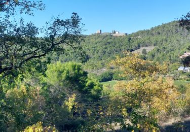
à ne pas faire par temps de mistral, galère.


Randonnées à proximité

Randonnée Marche Portes-en-Valdaine - Portes en Valdaine la plaine 7km - Photo
Marche
GUIDE
thonyc

Marche

Facile
(1)
Portes-en-Valdaine, Auvergne-Rhône-Alpes, Drôme, France
7,1 km | 8,2 km-effort
2h 0min
Oui
Randonnée Marche Portes-en-Valdaine - Portes-en-Valdaine Serre-de-Mirabel 11km. - Photo
Marche
chancha

Marche

Difficile
(1)
Portes-en-Valdaine, Auvergne-Rhône-Alpes, Drôme, France
10,8 km | 14,7 km-effort
3h 20min
Oui
Randonnée V.T.T. Puygiron - Puygiron VTT n°5 - Photo
V.T.T.
tracegps

V.T.T.

Très difficile
(1)
Puygiron, Auvergne-Rhône-Alpes, Drôme, France
47 km | 60 km-effort
3h 0min
Oui
Randonnée Marche La Touche - La Touche Crêtes de l'ysard 12km. - Photo
Marche
chancha

Marche

Difficile
(1)
La Touche, Auvergne-Rhône-Alpes, Drôme, France
12,1 km | 16,8 km-effort
3h 48min
Oui
Randonnée Marche Portes-en-Valdaine - 26 portes en valdaine - Photo
Marche
GUIDE
randodyssée

Marche

Très facile
Portes-en-Valdaine, Auvergne-Rhône-Alpes, Drôme, France
10,6 km | 14,5 km-effort
4h 10min
Oui
Randonnée Marche Puygiron - 26 Puygiron au coucher du soleil  - Photo
Marche
Maryma

Marche

Moyen
Puygiron, Auvergne-Rhône-Alpes, Drôme, France
5,7 km | 8,1 km-effort
1h 50min
Oui
Randonnée Marche Montboucher-sur-Jabron - 20240428 Rando vieux  - Photo
Marche
Havani

Marche

Très facile
Montboucher-sur-Jabron, Auvergne-Rhône-Alpes, Drôme, France
6,1 km | 6,5 km-effort
5h 17min
Oui
Randonnée Marche Rochefort-en-Valdaine - Rochefort en Valdaine 7,5km - Photo
Marche
GUIDE
thonyc

Marche

Facile
Rochefort-en-Valdaine, Auvergne-Rhône-Alpes, Drôme, France
7,3 km | 10,3 km-effort
2h 30min
Oui
Randonnée A pied Portes-en-Valdaine - Randonnée Trail Portes en Valdaine - Photo
A pied
Julie LABBE

A pied

Moyen
(1)
Portes-en-Valdaine, Auvergne-Rhône-Alpes, Drôme, France
19,4 km | 27 km-effort
6h 9min
Oui


Fermer
Mes abonnements