![](/images/other/stat-length.png)
![Randonnée Marche Lus-la-Croix-Haute - Tour du vallon de la Jarjatte - Photo](https://media.geolcdn.com/t/1900/400/ext.pjpeg?maxdim=2&url=https%3A%2F%2Fstatic1.geolcdn.com%2Fsiteimages%2Fupload%2Ffiles%2F1553511878bg_sport_marche.png)
Tour du vallon de la Jarjatte
pb07
Utilisateur
![Longueur](/images/other/stat-length.png)
Longueur
15,8 km
![Altitude max](https://static1.geolcdn.com/siteimages/upload/files/1508320355ic_sort_altitude_max_24dp.png)
Altitude max
1631 m
![Dénivelé positif](https://static1.geolcdn.com/siteimages/upload/files/1508320355ic_sort_den_pos_24dp.png)
Dénivelé positif
765 m
![Km-Effort](/images/other/stat-length.png)
Km-Effort
26 km
![Altitude min](https://static1.geolcdn.com/siteimages/upload/files/1508320355ic_sort_altitude_min_24dp.png)
Altitude min
1155 m
![Dénivelé négatif](https://static1.geolcdn.com/siteimages/upload/files/1508320355ic_sort_den_neg_24dp.png)
Dénivelé négatif
775 m
![Boucle](https://static1.geolcdn.com/siteimages/upload/files/16400158638029165_repeat_loop_refresh_sync_direction_icon.png)
Boucle
Oui
Date de création :
2015-09-12 00:00:00.0
Dernière modification :
2015-09-12 00:00:00.0
![Marche](https://static1.geolcdn.com/sitytour/trail-icons/101.png)
5h20
Difficulté : Moyen
![Scannez ce code QR pour ouvrir la randonnée dans l'application SityTrail](https://capi.geolives.com/qq0zvz2zws4bq2lad0pu/sitytour/trails/470975/qr.png?size=200)
Application GPS de randonnée GRATUITE
À propos
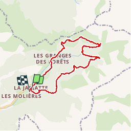
Randonnée Marche de 15,8 km à découvrir à Auvergne-Rhône-Alpes, Drôme, Lus-la-Croix-Haute. Cette randonnée est proposée par pb07.
Description
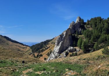
Randonnée de moyenne altitude, d'abord sur le versant Nord frais et boisé puis sur le versant sud dans les pâturages.
Le pont sur le Buech avant le Ravin du Fleytard a été détruit. La traversée peut être impraticable par hautes eaux.
Localisation
Pays :
France
Région :
Auvergne-Rhône-Alpes
Département/Province :
Drôme
Commune :
Lus-la-Croix-Haute
Localité :
Unknown
Départ:(Dec)
Départ:(UTM)
718637 ; 4950485 (31T) N.
Commentaires
Randonnées à proximité
![Randonnée Marche Lus-la-Croix-Haute - Pointe Feuillette - Photo](https://media.geolcdn.com/t/375/260/c32e652d-9142-443d-9f13-87284c6d10a4.jpg&format=jpg&maxdim=2)
![Marche Marche](https://static1.geolcdn.com/sitytour/trail-icons/101.png)
Pointe Feuillette
Marche
Difficile
Lus-la-Croix-Haute,
Auvergne-Rhône-Alpes,
Drôme,
France
![](/images/other/stat-length.png)
10,5 km | 20 km-effort
4h 36min
![](https://static1.geolcdn.com/siteimages/upload/files/16400158638029165_repeat_loop_refresh_sync_direction_icon.png)
Oui
![Randonnée Marche Saint-Julien-en-Beauchêne - Chamousset - Photo](https://media.geolcdn.com/t/375/260/3de74403-25a3-49ab-9973-c51b370cf75f.jpg&format=jpg&maxdim=2)
![Marche Marche](https://static1.geolcdn.com/sitytour/trail-icons/101.png)
Chamousset
Marche
Difficile
Saint-Julien-en-Beauchêne,
Provence-Alpes-Côte d'Azur,
Hautes-Alpes,
France
![](/images/other/stat-length.png)
11,2 km | 22 km-effort
5h 1min
![](https://static1.geolcdn.com/siteimages/upload/files/16400158638029165_repeat_loop_refresh_sync_direction_icon.png)
Oui
![Randonnée Marche Lus-la-Croix-Haute - Tête de longue plate - Photo](https://media.geolcdn.com/t/375/260/0a20c58f-3b20-47ed-aad5-45f7c05509bb.jpg&format=jpg&maxdim=2)
![Marche Marche](https://static1.geolcdn.com/sitytour/trail-icons/101.png)
Tête de longue plate
Marche
Difficile
Lus-la-Croix-Haute,
Auvergne-Rhône-Alpes,
Drôme,
France
![](/images/other/stat-length.png)
11 km | 26 km-effort
6h 40min
![](https://static1.geolcdn.com/siteimages/upload/files/16400158638029165_repeat_loop_refresh_sync_direction_icon.png)
Oui
![Randonnée Marche Lus-la-Croix-Haute - R48 - Gorges des Amayères - Photo](https://media.geolcdn.com/t/375/260/4bbc825f-a565-4275-9665-85da99118f1b.jpg&format=jpg&maxdim=2)
![Marche Marche](https://static1.geolcdn.com/sitytour/trail-icons/101.png)
R48 - Gorges des Amayères
Marche
Facile
Lus-la-Croix-Haute,
Auvergne-Rhône-Alpes,
Drôme,
France
![](/images/other/stat-length.png)
10,3 km | 17,5 km-effort
3h 1min
![](https://static1.geolcdn.com/siteimages/upload/files/16400158638029165_repeat_loop_refresh_sync_direction_icon.png)
Non
![Randonnée Marche Lus-la-Croix-Haute - R41 le lac de Lauzon - Photo](https://media.geolcdn.com/t/375/260/ext.jpg?maxdim=2&url=https%3A%2F%2Fservices.sitytrail.com%2FGeolivesWS%2FDownloadMedia.ashx%3FTrailID%3D890899%26Media%3Df5ddbda0-05f9-4668-87b6-f4718cf6a3db.jpg)
![Marche Marche](https://static1.geolcdn.com/sitytour/trail-icons/101.png)
R41 le lac de Lauzon
Marche
Difficile
Lus-la-Croix-Haute,
Auvergne-Rhône-Alpes,
Drôme,
France
![](/images/other/stat-length.png)
8,1 km | 18,7 km-effort
3h 40min
![](https://static1.geolcdn.com/siteimages/upload/files/16400158638029165_repeat_loop_refresh_sync_direction_icon.png)
Oui
![Randonnée Marche Lus-la-Croix-Haute - R38 Col des Aiguilles depuis Lus - Photo](https://media.geolcdn.com/t/375/260/ext.jpg?maxdim=2&url=https%3A%2F%2Fservices.sitytrail.com%2FGeolivesWS%2FDownloadMedia.ashx%3FTrailID%3D890897%26Media%3D48008b69-5aeb-41cb-8dd0-25fe44b6160d.jpg)
![Marche Marche](https://static1.geolcdn.com/sitytour/trail-icons/101.png)
R38 Col des Aiguilles depuis Lus
Marche
Moyen
Lus-la-Croix-Haute,
Auvergne-Rhône-Alpes,
Drôme,
France
![](/images/other/stat-length.png)
5,6 km | 15 km-effort
2h 53min
![](https://static1.geolcdn.com/siteimages/upload/files/16400158638029165_repeat_loop_refresh_sync_direction_icon.png)
Oui
![Randonnée Marche Lus-la-Croix-Haute - R37 Col de la Croix - Photo](https://media.geolcdn.com/t/375/260/ext.jpg?maxdim=2&url=https%3A%2F%2Fservices.sitytrail.com%2FGeolivesWS%2FDownloadMedia.ashx%3FTrailID%3D890896%26Media%3D15be88b3-d922-4917-ae78-ab5d93ffe684.jpg)
![Marche Marche](https://static1.geolcdn.com/sitytour/trail-icons/101.png)
R37 Col de la Croix
Marche
Moyen
Lus-la-Croix-Haute,
Auvergne-Rhône-Alpes,
Drôme,
France
![](/images/other/stat-length.png)
3,7 km | 7 km-effort
1h 27min
![](https://static1.geolcdn.com/siteimages/upload/files/16400158638029165_repeat_loop_refresh_sync_direction_icon.png)
Oui
![Randonnée Marche Lus-la-Croix-Haute - Le Rognon - Photo](https://media.geolcdn.com/t/375/260/ext.jpg?maxdim=2&url=https%3A%2F%2Fstatic1.geolcdn.com%2Fsiteimages%2Fupload%2Ffiles%2F1553511878bg_sport_marche.png)
![Marche Marche](https://static1.geolcdn.com/sitytour/trail-icons/101.png)
Le Rognon
Marche
Moyen
(1)
Lus-la-Croix-Haute,
Auvergne-Rhône-Alpes,
Drôme,
France
![](/images/other/stat-length.png)
12,3 km | 22 km-effort
4h 33min
![](https://static1.geolcdn.com/siteimages/upload/files/16400158638029165_repeat_loop_refresh_sync_direction_icon.png)
Oui
![Randonnée Marche Saint-Julien-en-Beauchêne - tour des 4 cols - Photo](https://media.geolcdn.com/t/375/260/8527f1e3-99e4-45a7-995d-0319f3af7da7.jpg&format=jpg&maxdim=2)
![Marche Marche](https://static1.geolcdn.com/sitytour/trail-icons/101.png)
tour des 4 cols
Marche
Très difficile
Saint-Julien-en-Beauchêne,
Provence-Alpes-Côte d'Azur,
Hautes-Alpes,
France
![](/images/other/stat-length.png)
13,2 km | 24 km-effort
5h 25min
![](https://static1.geolcdn.com/siteimages/upload/files/16400158638029165_repeat_loop_refresh_sync_direction_icon.png)
Oui