![](/images/other/stat-length.png)
![Randonnée Marche The Municipal District of Cahir — Cashel - Cahir Scaragh Wood Trail 3 - Photo](https://media.geolcdn.com/t/1900/400/ext.pjpeg?maxdim=2&url=https%3A%2F%2Fservices.sitytrail.com%2FGeolivesWS%2FDownloadMedia.ashx%3FTrailID%3D47054%26Media%3Dimage5.jpg)
Cahir Scaragh Wood Trail 3
johnkeating
Utilisateur
![Longueur](/images/other/stat-length.png)
Longueur
6,4 km
![Altitude max](https://static1.geolcdn.com/siteimages/upload/files/1508320355ic_sort_altitude_max_24dp.png)
Altitude max
299 m
![Dénivelé positif](https://static1.geolcdn.com/siteimages/upload/files/1508320355ic_sort_den_pos_24dp.png)
Dénivelé positif
220 m
![Km-Effort](/images/other/stat-length.png)
Km-Effort
9,4 km
![Altitude min](https://static1.geolcdn.com/siteimages/upload/files/1508320355ic_sort_altitude_min_24dp.png)
Altitude min
99 m
![Dénivelé négatif](https://static1.geolcdn.com/siteimages/upload/files/1508320355ic_sort_den_neg_24dp.png)
Dénivelé négatif
225 m
![Boucle](https://static1.geolcdn.com/siteimages/upload/files/16400158638029165_repeat_loop_refresh_sync_direction_icon.png)
Boucle
Oui
Date de création :
2014-12-10 00:00:00.0
Dernière modification :
2014-12-10 00:00:00.0
![Marche](https://static1.geolcdn.com/sitytour/trail-icons/101.png)
1h35
Difficulté : Inconnu
![Scannez ce code QR pour ouvrir la randonnée dans l'application SityTrail](https://capi.geolives.com/qq0zvz2zws4bq2lad0pu/sitytour/trails/47054/qr.png?size=200)
Application GPS de randonnée GRATUITE
À propos
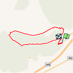
Randonnée Marche de 6,4 km à découvrir à Inconnu, County Tipperary, The Municipal District of Cahir — Cashel. Cette randonnée est proposée par johnkeating.
Description
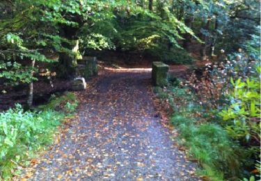
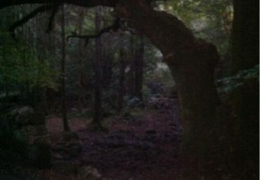
Park 50 metres from Mountain Road entrace to Scaragh Wood. Trail follows forest tracks upwards to open mountain. Remains above tree line with excellent views of Cahir, Knockmealdowns, Comeraghs and Slievnamon. Descends via forest track and small paths.
Localisation
Pays :
Irlande
Région :
Inconnu
Département/Province :
County Tipperary
Commune :
The Municipal District of Cahir — Cashel
Localité :
Kilcommon
Départ:(Dec)
Départ:(UTM)
570883 ; 5803432 (29U) N.
Commentaires
Randonnées à proximité
![Randonnée Marche The Municipal District of Cahir — Cashel - Cahir Scaragh Wood Trail 2 - Photo](https://media.geolcdn.com/t/375/260/ext.jpg?maxdim=2&url=https%3A%2F%2Fservices.sitytrail.com%2FGeolivesWS%2FDownloadMedia.ashx%3FTrailID%3D47228%26Media%3Dimage7.jpg)
![Marche Marche](https://static1.geolcdn.com/sitytour/trail-icons/101.png)
Cahir Scaragh Wood Trail 2
Marche
Très facile
The Municipal District of Cahir — Cashel,
Inconnu,
County Tipperary,
Irlande
![](/images/other/stat-length.png)
5,5 km | 7,4 km-effort
1h 15min
![](https://static1.geolcdn.com/siteimages/upload/files/16400158638029165_repeat_loop_refresh_sync_direction_icon.png)
Oui
![Randonnée Marche The Municipal District of Cahir — Cashel - Cahir Scaragh Wood Trail 1 - Photo](https://media.geolcdn.com/t/375/260/ext.jpg?maxdim=2&url=https%3A%2F%2Fservices.sitytrail.com%2FGeolivesWS%2FDownloadMedia.ashx%3FTrailID%3D47126%26Media%3Dimage2.jpg)
![Marche Marche](https://static1.geolcdn.com/sitytour/trail-icons/101.png)
Cahir Scaragh Wood Trail 1
Marche
Très facile
The Municipal District of Cahir — Cashel,
Inconnu,
County Tipperary,
Irlande
![](/images/other/stat-length.png)
4,6 km | 5,9 km-effort
1h 0min
![](https://static1.geolcdn.com/siteimages/upload/files/16400158638029165_repeat_loop_refresh_sync_direction_icon.png)
Oui