![](/images/other/stat-length.png)
![Randonnée Vélo Montfaucon - Boucle de 145 kms - Photo](https://media.geolcdn.com/t/1900/400/ext.pjpeg?maxdim=2&url=https%3A%2F%2Fstatic1.geolcdn.com%2Fsiteimages%2Fupload%2Ffiles%2F1524743154velo.jpg)
Boucle de 145 kms
BernardSalomon
Utilisateur
![Longueur](/images/other/stat-length.png)
Longueur
144 km
![Altitude max](https://static1.geolcdn.com/siteimages/upload/files/1508320355ic_sort_altitude_max_24dp.png)
Altitude max
807 m
![Dénivelé positif](https://static1.geolcdn.com/siteimages/upload/files/1508320355ic_sort_den_pos_24dp.png)
Dénivelé positif
2345 m
![Km-Effort](/images/other/stat-length.png)
Km-Effort
175 km
![Altitude min](https://static1.geolcdn.com/siteimages/upload/files/1508320355ic_sort_altitude_min_24dp.png)
Altitude min
276 m
![Dénivelé négatif](https://static1.geolcdn.com/siteimages/upload/files/1508320355ic_sort_den_neg_24dp.png)
Dénivelé négatif
2344 m
![Boucle](https://static1.geolcdn.com/siteimages/upload/files/16400158638029165_repeat_loop_refresh_sync_direction_icon.png)
Boucle
Oui
Date de création :
2015-09-03 00:00:00.0
Dernière modification :
2015-09-03 00:00:00.0
![Vélo](https://static1.geolcdn.com/sitytour/trail-icons/200.png)
6h17
Difficulté : Difficile
![Scannez ce code QR pour ouvrir la randonnée dans l'application SityTrail](https://capi.geolives.com/qq0zvz2zws4bq2lad0pu/sitytour/trails/467625/qr.png?size=200)
Application GPS de randonnée GRATUITE
À propos
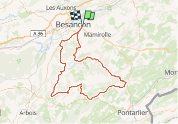
Randonnée Vélo de 144 km à découvrir à Bourgogne-Franche-Comté, Doubs, Montfaucon. Cette randonnée est proposée par BernardSalomon.
Description
Montfaucon Epeugney Scey Ornans La Main Ouhans Levier Déservillers Nans sous Ste Anne Myon Cussey Pont de Rurey Charnay Chenecey Fontain et retour
Localisation
Pays :
France
Région :
Bourgogne-Franche-Comté
Département/Province :
Doubs
Commune :
Montfaucon
Localité :
Unknown
Départ:(Dec)
Départ:(UTM)
278790 ; 5234860 (32T) N.
Commentaires
Randonnées à proximité
![Randonnée Marche Montfaucon - Du chateau au fort de Monfaucon - Photo](https://media.geolcdn.com/t/375/260/ext.jpg?maxdim=2&url=https%3A%2F%2Fservices.sitytrail.com%2FGeolivesWS%2FDownloadMedia.ashx%3FTrailID%3D705744%26Media%3Dfix__20170226154846.jpg)
![Marche Marche](https://static1.geolcdn.com/sitytour/trail-icons/101.png)
Du chateau au fort de Monfaucon
Marche
Facile
(1)
Montfaucon,
Bourgogne-Franche-Comté,
Doubs,
France
![](/images/other/stat-length.png)
6,9 km | 9,3 km-effort
1h 55min
![](https://static1.geolcdn.com/siteimages/upload/files/16400158638029165_repeat_loop_refresh_sync_direction_icon.png)
Oui
![Randonnée Marche Besançon - Colline de Besançon 29-08-2020 - Photo](https://media.geolcdn.com/t/375/260/1e155548-d400-46d3-8b28-207c9933a379.jpg&format=jpg&maxdim=2)
![Marche Marche](https://static1.geolcdn.com/sitytour/trail-icons/101.png)
Colline de Besançon 29-08-2020
Marche
Moyen
(1)
Besançon,
Bourgogne-Franche-Comté,
Doubs,
France
![](/images/other/stat-length.png)
13,4 km | 17,7 km-effort
2h 46min
![](https://static1.geolcdn.com/siteimages/upload/files/16400158638029165_repeat_loop_refresh_sync_direction_icon.png)
Oui
![Randonnée Marche Fontain - fontain - fort de Fontain - forêt de Fontain - Photo](https://media.geolcdn.com/t/375/260/dda8671d-de1b-4872-afba-e5376a2d57f0.jpg&format=jpg&maxdim=2)
![Marche Marche](https://static1.geolcdn.com/sitytour/trail-icons/101.png)
fontain - fort de Fontain - forêt de Fontain
Marche
Très facile
(2)
Fontain,
Bourgogne-Franche-Comté,
Doubs,
France
![](/images/other/stat-length.png)
11,9 km | 15,2 km-effort
3h 11min
![](https://static1.geolcdn.com/siteimages/upload/files/16400158638029165_repeat_loop_refresh_sync_direction_icon.png)
Oui
![Randonnée A pied Mamirolle - Sentier du Bois de la Fougère - Photo](https://media.geolcdn.com/t/375/260/a8a8f146-f198-41be-852b-9ac1789ecd72.jpeg&format=jpg&maxdim=2)
![A pied A pied](https://static1.geolcdn.com/sitytour/trail-icons/100.png)
Sentier du Bois de la Fougère
A pied
Facile
Mamirolle,
Bourgogne-Franche-Comté,
Doubs,
France
![](/images/other/stat-length.png)
7,3 km | 8,7 km-effort
1h 58min
![](https://static1.geolcdn.com/siteimages/upload/files/16400158638029165_repeat_loop_refresh_sync_direction_icon.png)
Oui
![Randonnée A pied Montfaucon - Boucle de Nacra - Photo](https://media.geolcdn.com/t/375/260/754b99f9-55b9-4375-839c-408b044dfd0e.jpeg&format=jpg&maxdim=2)
![A pied A pied](https://static1.geolcdn.com/sitytour/trail-icons/100.png)
Boucle de Nacra
A pied
Facile
Montfaucon,
Bourgogne-Franche-Comté,
Doubs,
France
![](/images/other/stat-length.png)
3 km | 4,4 km-effort
1h 0min
![](https://static1.geolcdn.com/siteimages/upload/files/16400158638029165_repeat_loop_refresh_sync_direction_icon.png)
Oui
![Randonnée A pied Saône - Sentier des Essarts - Photo](https://media.geolcdn.com/t/375/260/bda44002-ccb3-4d91-bd01-33fbc5477f0c.jpeg&format=jpg&maxdim=2)
![A pied A pied](https://static1.geolcdn.com/sitytour/trail-icons/100.png)
Sentier des Essarts
A pied
Facile
Saône,
Bourgogne-Franche-Comté,
Doubs,
France
![](/images/other/stat-length.png)
6,9 km | 8,1 km-effort
1h 50min
![](https://static1.geolcdn.com/siteimages/upload/files/16400158638029165_repeat_loop_refresh_sync_direction_icon.png)
Oui
![Randonnée A pied Montfaucon - Sentier des Falaises et du château - Photo](https://media.geolcdn.com/t/375/260/5325d98d-322b-4b71-b21b-224d670c2150.jpeg&format=jpg&maxdim=2)
![A pied A pied](https://static1.geolcdn.com/sitytour/trail-icons/100.png)
Sentier des Falaises et du château
A pied
Facile
Montfaucon,
Bourgogne-Franche-Comté,
Doubs,
France
![](/images/other/stat-length.png)
5 km | 7,1 km-effort
1h 37min
![](https://static1.geolcdn.com/siteimages/upload/files/16400158638029165_repeat_loop_refresh_sync_direction_icon.png)
Oui
![Randonnée A pied Montfaucon - Sentier du Fort et des Batteries - Photo](https://media.geolcdn.com/t/375/260/465eae89-7ad3-4616-8710-419d54be2030.jpeg&format=jpg&maxdim=2)
![A pied A pied](https://static1.geolcdn.com/sitytour/trail-icons/100.png)
Sentier du Fort et des Batteries
A pied
Facile
Montfaucon,
Bourgogne-Franche-Comté,
Doubs,
France
![](/images/other/stat-length.png)
6,6 km | 8,7 km-effort
1h 58min
![](https://static1.geolcdn.com/siteimages/upload/files/16400158638029165_repeat_loop_refresh_sync_direction_icon.png)
Oui
![Randonnée A pied Fontain - Grande Boucle de Fontain - Photo](https://media.geolcdn.com/t/375/260/f1d37a4d-b9db-4571-aaef-737a004f40e0.jpeg&format=jpg&maxdim=2)
![A pied A pied](https://static1.geolcdn.com/sitytour/trail-icons/100.png)
Grande Boucle de Fontain
A pied
Facile
(1)
Fontain,
Bourgogne-Franche-Comté,
Doubs,
France
![](/images/other/stat-length.png)
10 km | 13,2 km-effort
2h 59min
![](https://static1.geolcdn.com/siteimages/upload/files/16400158638029165_repeat_loop_refresh_sync_direction_icon.png)
Oui