![](/images/other/stat-length.png)
![Randonnée Marche Saint-Philippe - Caverne des gendarmes - Photo](https://media.geolcdn.com/t/1900/400/ext.pjpeg?maxdim=2&url=https%3A%2F%2Fstatic1.geolcdn.com%2Fsiteimages%2Fupload%2Ffiles%2F1553511878bg_sport_marche.png)
Caverne des gendarmes
Fdum
Utilisateur
![Longueur](/images/other/stat-length.png)
Longueur
3,1 km
![Altitude max](https://static1.geolcdn.com/siteimages/upload/files/1508320355ic_sort_altitude_max_24dp.png)
Altitude max
142 m
![Dénivelé positif](https://static1.geolcdn.com/siteimages/upload/files/1508320355ic_sort_den_pos_24dp.png)
Dénivelé positif
94 m
![Km-Effort](/images/other/stat-length.png)
Km-Effort
4,3 km
![Altitude min](https://static1.geolcdn.com/siteimages/upload/files/1508320355ic_sort_altitude_min_24dp.png)
Altitude min
41 m
![Dénivelé négatif](https://static1.geolcdn.com/siteimages/upload/files/1508320355ic_sort_den_neg_24dp.png)
Dénivelé négatif
94 m
![Boucle](https://static1.geolcdn.com/siteimages/upload/files/16400158638029165_repeat_loop_refresh_sync_direction_icon.png)
Boucle
Oui
Date de création :
2016-03-09 00:00:00.0
Dernière modification :
2016-03-09 00:00:00.0
![Marche](https://static1.geolcdn.com/sitytour/trail-icons/101.png)
57m
Difficulté : Facile
![Scannez ce code QR pour ouvrir la randonnée dans l'application SityTrail](https://capi.geolives.com/qq0zvz2zws4bq2lad0pu/sitytour/trails/464348/qr.png?size=200)
Application GPS de randonnée GRATUITE
À propos
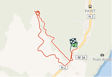
Randonnée Marche de 3,1 km à découvrir à La Réunion, Inconnu, Saint-Philippe. Cette randonnée est proposée par Fdum.
Description
Site officiellement interdit... Ancien tunnel de lave. La trace montre une recherche de notre part pour trouver ce site. Il est donc préférable de monter via la piste dans les champs de cannes (Descente). Très sympa
Localisation
Pays :
France
Région :
La Réunion
Département/Province :
Inconnu
Commune :
Saint-Philippe
Localité :
Unknown
Départ:(Dec)
Départ:(UTM)
375446 ; 7639807 (40K) S.
Commentaires
Randonnées à proximité
![Randonnée Marche Saint-Philippe - Jardin des Laves Puits Arabe - Photo](https://media.geolcdn.com/t/375/260/ext.jpg?maxdim=2&url=https%3A%2F%2Fservices.sitytrail.com%2FGeolivesWS%2FDownloadMedia.ashx%3FTrailID%3D452674%26Media%3Dfix__20150724115043.jpg)
![Marche Marche](https://static1.geolcdn.com/sitytour/trail-icons/101.png)
Jardin des Laves Puits Arabe
Marche
Facile
(1)
Saint-Philippe,
La Réunion,
Inconnu,
France
![](/images/other/stat-length.png)
4,3 km | 4,8 km-effort
1h 44min
![](https://static1.geolcdn.com/siteimages/upload/files/16400158638029165_repeat_loop_refresh_sync_direction_icon.png)
Oui
![Randonnée Marche Saint-Philippe - chasse - Photo](https://media.geolcdn.com/t/375/260/ext.jpg?maxdim=2&url=https%3A%2F%2Fstatic1.geolcdn.com%2Fsiteimages%2Fupload%2Ffiles%2F1553511878bg_sport_marche.png)
![Marche Marche](https://static1.geolcdn.com/sitytour/trail-icons/101.png)
chasse
Marche
Moyen
Saint-Philippe,
La Réunion,
Inconnu,
France
![](/images/other/stat-length.png)
5,8 km | 10,1 km-effort
8h 21min
![](https://static1.geolcdn.com/siteimages/upload/files/16400158638029165_repeat_loop_refresh_sync_direction_icon.png)
Non
![Randonnée Marche Saint-Philippe - Route forestière takamaka et descente vers la pointe de la table - Photo](https://media.geolcdn.com/t/375/260/ext.jpg?maxdim=2&url=https%3A%2F%2Fstatic1.geolcdn.com%2Fsiteimages%2Fupload%2Ffiles%2F1553511878bg_sport_marche.png)
![Marche Marche](https://static1.geolcdn.com/sitytour/trail-icons/101.png)
Route forestière takamaka et descente vers la pointe de la table
Marche
Moyen
Saint-Philippe,
La Réunion,
Inconnu,
France
![](/images/other/stat-length.png)
11,9 km | 16,7 km-effort
3h 37min
![](https://static1.geolcdn.com/siteimages/upload/files/16400158638029165_repeat_loop_refresh_sync_direction_icon.png)
Oui
![Randonnée Autre activité Saint-Philippe - tanaka - Photo](https://media.geolcdn.com/t/375/260/ext.jpg?maxdim=2&url=https%3A%2F%2Fstatic1.geolcdn.com%2Fsiteimages%2Fupload%2Ffiles%2F1545311037marcheuse_200dpi.jpg)
![Autre activité Autre activité](https://static1.geolcdn.com/sitytour/trail-icons/900.png)
tanaka
Autre activité
Très facile
Saint-Philippe,
La Réunion,
Inconnu,
France
![](/images/other/stat-length.png)
4,3 km | 13,6 km-effort
2h 0min
![](https://static1.geolcdn.com/siteimages/upload/files/16400158638029165_repeat_loop_refresh_sync_direction_icon.png)
Non
![Randonnée sport Saint-Philippe - 2024-10-12_17h09m57_Randopitons Itineraire #1433 - Tour Takamaka Rf Takamaka Littoral Pointe Table - Photo](https://media.geolcdn.com/t/375/260/ext.jpg?maxdim=2&url=https%3A%2F%2Fsecurestorage.geolives.com%2Fsitytour%2Ftrail-bg%2Fdefault.jpg)
2024-10-12_17h09m57_Randopitons Itineraire #1433 - Tour Takamaka Rf Takamaka ...
sport
Très facile
(1)
Saint-Philippe,
La Réunion,
Inconnu,
France
![](/images/other/stat-length.png)
11,8 km | 16,6 km-effort
Inconnu
![](https://static1.geolcdn.com/siteimages/upload/files/16400158638029165_repeat_loop_refresh_sync_direction_icon.png)
Oui
![Randonnée Vélo de route Saint-Philippe - st Philippe - l'étang salé par ma plaine des palmistes - Photo](https://media.geolcdn.com/t/375/260/ext.jpg?maxdim=2&url=https%3A%2F%2Fstatic1.geolcdn.com%2Fsiteimages%2Fupload%2Ffiles%2F1524743154velo.jpg)
![Vélo de route Vélo de route](https://static1.geolcdn.com/sitytour/trail-icons/201.png)
st Philippe - l'étang salé par ma plaine des palmistes
Vélo de route
Moyen
Saint-Philippe,
La Réunion,
Inconnu,
France
![](/images/other/stat-length.png)
118 km | 151 km-effort
9h 45min
![](https://static1.geolcdn.com/siteimages/upload/files/16400158638029165_repeat_loop_refresh_sync_direction_icon.png)
Non
![Randonnée Marche Saint-Philippe - Pointe table_Tremblet - Photo](https://media.geolcdn.com/t/375/260/ext.jpg?maxdim=2&url=https%3A%2F%2Fstatic1.geolcdn.com%2Fsiteimages%2Fupload%2Ffiles%2F1553511878bg_sport_marche.png)
![Marche Marche](https://static1.geolcdn.com/sitytour/trail-icons/101.png)
Pointe table_Tremblet
Marche
Très facile
Saint-Philippe,
La Réunion,
Inconnu,
France
![](/images/other/stat-length.png)
13,7 km | 17,3 km-effort
4h 41min
![](https://static1.geolcdn.com/siteimages/upload/files/16400158638029165_repeat_loop_refresh_sync_direction_icon.png)
Oui
![Randonnée Marche Saint-Philippe - Mer cassée _ Pointe de la table - Photo](https://media.geolcdn.com/t/375/260/ext.jpg?maxdim=2&url=https%3A%2F%2Fstatic1.geolcdn.com%2Fsiteimages%2Fupload%2Ffiles%2F1553511878bg_sport_marche.png)
![Marche Marche](https://static1.geolcdn.com/sitytour/trail-icons/101.png)
Mer cassée _ Pointe de la table
Marche
Très facile
Saint-Philippe,
La Réunion,
Inconnu,
France
![](/images/other/stat-length.png)
17,4 km | 20 km-effort
6h 51min
![](https://static1.geolcdn.com/siteimages/upload/files/16400158638029165_repeat_loop_refresh_sync_direction_icon.png)
Oui