![](/images/other/stat-length.png)
![Randonnée Raquettes à neige Orsières - Champex-Lac, Sentier Raquettes n° 3, La Source - Photo](https://media.geolcdn.com/t/1900/400/ext.pjpeg?maxdim=2&url=https%3A%2F%2Fstatic1.geolcdn.com%2Fsiteimages%2Fupload%2Ffiles%2F1524743153raquette.jpg)
Champex-Lac, Sentier Raquettes n° 3, La Source
verbier
Utilisateur
![Longueur](/images/other/stat-length.png)
![Altitude max](https://static1.geolcdn.com/siteimages/upload/files/1508320355ic_sort_altitude_max_24dp.png)
![Dénivelé positif](https://static1.geolcdn.com/siteimages/upload/files/1508320355ic_sort_den_pos_24dp.png)
![Km-Effort](/images/other/stat-length.png)
![Altitude min](https://static1.geolcdn.com/siteimages/upload/files/1508320355ic_sort_altitude_min_24dp.png)
![Dénivelé négatif](https://static1.geolcdn.com/siteimages/upload/files/1508320355ic_sort_den_neg_24dp.png)
![Boucle](https://static1.geolcdn.com/siteimages/upload/files/16400158638029165_repeat_loop_refresh_sync_direction_icon.png)
![Raquettes à neige](https://static1.geolcdn.com/sitytour/trail-icons/504.png)
1h30
Difficulté : Inconnu
![Scannez ce code QR pour ouvrir la randonnée dans l'application SityTrail](https://capi.geolives.com/qq0zvz2zws4bq2lad0pu/sitytour/trails/46206/qr.png?size=200)
Application GPS de randonnée GRATUITE
À propos
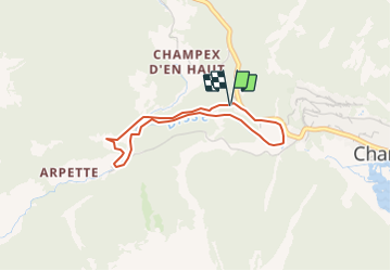
Randonnée Raquettes à neige de 2,9 km à découvrir à Valais, Entremont, Orsières. Cette randonnée est proposée par verbier.
Description
Parquer la voiture sur la grande place des remontées mécaniques. Prendre la direction "Champex d''en haut" côté ouest.
Emprunter le sentier indiqué qui remonte sur la gauche dans la forêt vers le "Val d''Arpette". Au sortir de la forêt, poursuivre le long du ruisseau. Ne pas dépasser la limite de la protection de la forêt et revenir par "la source du Durnand".
Ce parcours se réfère aux panneaux N°3
Localisation
Commentaires
Randonnées à proximité
![Randonnée A pied Orsières - Chemins pédestre de montagne, commune d'Orsières - Photo](https://media.geolcdn.com/t/375/260/6dfeee0d-887b-4c9c-aefd-3dcd0ea22569.jpeg&format=jpg&maxdim=2)
![A pied A pied](https://static1.geolcdn.com/sitytour/trail-icons/100.png)
A pied
![](/images/other/stat-length.png)
![](https://static1.geolcdn.com/siteimages/upload/files/16400158638029165_repeat_loop_refresh_sync_direction_icon.png)
![Randonnée A pied Orsières - sentier du Devin - Photo](https://media.geolcdn.com/t/375/260/1486fc85-352e-404e-b600-0f3d7bac1924.jpeg&format=jpg&maxdim=2)
![A pied A pied](https://static1.geolcdn.com/sitytour/trail-icons/100.png)
A pied
![](/images/other/stat-length.png)
![](https://static1.geolcdn.com/siteimages/upload/files/16400158638029165_repeat_loop_refresh_sync_direction_icon.png)
![Randonnée A pied Orsières - Chemins pédestre, commune d'Orsières - Photo](https://media.geolcdn.com/t/375/260/70edd484-9073-4e02-96d0-3d17425bab34.jpeg&format=jpg&maxdim=2)
![A pied A pied](https://static1.geolcdn.com/sitytour/trail-icons/100.png)
A pied
![](/images/other/stat-length.png)
![](https://static1.geolcdn.com/siteimages/upload/files/16400158638029165_repeat_loop_refresh_sync_direction_icon.png)
![Randonnée A pied Bovernier - Chemins pédestre de montagne, région Entremont - Photo](https://media.geolcdn.com/t/375/260/8965cd81-5f88-4628-9726-209c4b98c789.jpeg&format=jpg&maxdim=2)
![A pied A pied](https://static1.geolcdn.com/sitytour/trail-icons/100.png)
A pied
![](/images/other/stat-length.png)
![](https://static1.geolcdn.com/siteimages/upload/files/16400158638029165_repeat_loop_refresh_sync_direction_icon.png)
![Randonnée Marche Liddes - Combe de l’A - Photo](https://media.geolcdn.com/t/375/260/80b3ab05-1db2-4115-987f-2856a50ccafd.jpg&format=jpg&maxdim=2)
![Marche Marche](https://static1.geolcdn.com/sitytour/trail-icons/101.png)
![Randonnée A pied Orsières - Raccard du blé - Photo](https://media.geolcdn.com/t/375/260/e3af305e-4edc-4919-bcad-22d8b69ac232.jpeg&format=jpg&maxdim=2)
![A pied A pied](https://static1.geolcdn.com/sitytour/trail-icons/100.png)
A pied
![](/images/other/stat-length.png)
![](https://static1.geolcdn.com/siteimages/upload/files/16400158638029165_repeat_loop_refresh_sync_direction_icon.png)
![Randonnée Marche Orsières - TMB 08 - Relais d'Arpette -> Trient - Photo](https://media.geolcdn.com/t/375/260/879d1358-40ae-4393-aa0f-3cd2dbd6e081.jpg&format=jpg&maxdim=2)
![Marche Marche](https://static1.geolcdn.com/sitytour/trail-icons/101.png)
Marche
![](/images/other/stat-length.png)
![](https://static1.geolcdn.com/siteimages/upload/files/16400158638029165_repeat_loop_refresh_sync_direction_icon.png)
![Randonnée Raquettes à neige Orsières - Champex Lac - La Breya - Champex Lac - Photo](https://media.geolcdn.com/t/375/260/6555df26-5e72-41d3-9ea4-2761199f667f.jpg&format=jpg&maxdim=2)
![Raquettes à neige Raquettes à neige](https://static1.geolcdn.com/sitytour/trail-icons/504.png)
Raquettes à neige
![](/images/other/stat-length.png)
![](https://static1.geolcdn.com/siteimages/upload/files/16400158638029165_repeat_loop_refresh_sync_direction_icon.png)
![Randonnée Marche Orsières - CMX ZRMT Étape 2 Champex Cabane de Mille - Photo](https://media.geolcdn.com/t/375/260/ext.jpg?maxdim=2&url=https%3A%2F%2Fservices.sitytrail.com%2FGeolivesWS%2FDownloadMedia.ashx%3FTrailID%3D635928%26Media%3Dfix__20160914135625.jpg)
![Marche Marche](https://static1.geolcdn.com/sitytour/trail-icons/101.png)
Marche
![](/images/other/stat-length.png)
![](https://static1.geolcdn.com/siteimages/upload/files/16400158638029165_repeat_loop_refresh_sync_direction_icon.png)