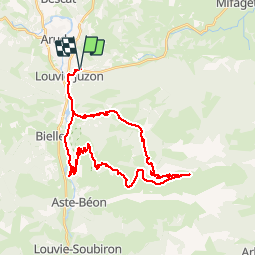
![](/images/other/stat-length.png)
![Randonnée V.T.T. Louvie-Juzon - louvie juzon. port de castet. col de jau. port de béon. - Photo](https://media.geolcdn.com/t/1900/400/ext.pjpeg?maxdim=2&url=https%3A%2F%2Fservices.sitytrail.com%2FGeolivesWS%2FDownloadMedia.ashx%3FTrailID%3D461359%26Media%3Dfix__20150819134831.jpg)
louvie juzon. port de castet. col de jau. port de béon.
francislassauce
Utilisateur
![Longueur](/images/other/stat-length.png)
![Altitude max](https://static1.geolcdn.com/siteimages/upload/files/1508320355ic_sort_altitude_max_24dp.png)
![Dénivelé positif](https://static1.geolcdn.com/siteimages/upload/files/1508320355ic_sort_den_pos_24dp.png)
![Km-Effort](/images/other/stat-length.png)
![Altitude min](https://static1.geolcdn.com/siteimages/upload/files/1508320355ic_sort_altitude_min_24dp.png)
![Dénivelé négatif](https://static1.geolcdn.com/siteimages/upload/files/1508320355ic_sort_den_neg_24dp.png)
![Boucle](https://static1.geolcdn.com/siteimages/upload/files/16400158638029165_repeat_loop_refresh_sync_direction_icon.png)
![V.T.T.](https://static1.geolcdn.com/sitytour/trail-icons/202.png)
4h29
Difficulté : Très difficile
![Scannez ce code QR pour ouvrir la randonnée dans l'application SityTrail](https://capi.geolives.com/qq0zvz2zws4bq2lad0pu/sitytour/trails/461359/qr.png?size=200)
Application GPS de randonnée GRATUITE
À propos
Randonnée V.T.T. de 38 km à découvrir à Nouvelle-Aquitaine, Pyrénées-Atlantiques, Louvie-Juzon. Cette randonnée est proposée par francislassauce.
Description
très roulant jusqu'au col de jau malgrès des pourcentages assez élevés.
ensuite il faut suivre le parcours VTT no 10 qui est balisé avec des petits poteaux au raz du sol. on roule dans la prairie en suivant des sentiers faits par les vaches. donc il y en a partout.
après qq kms j'ai perdu la trace des balises. donc j'ai fait au feeling.
la descente est super belle mais caillouteuse. 10kms environ de descente. super panoramas.
Localisation
Commentaires
Randonnées à proximité
![Randonnée Marche Louvie-Juzon - Soum de las Picarras Montagne du Rey - Photo](https://media.geolcdn.com/t/375/260/ext.jpg?maxdim=2&url=https%3A%2F%2Fservices.sitytrail.com%2FGeolivesWS%2FDownloadMedia.ashx%3FTrailID%3D541294%26Media%3Dfix__20160320134039.jpg)
![Marche Marche](https://static1.geolcdn.com/sitytour/trail-icons/101.png)
Marche
![](/images/other/stat-length.png)
![](https://static1.geolcdn.com/siteimages/upload/files/16400158638029165_repeat_loop_refresh_sync_direction_icon.png)
![Randonnée Marche Bielle - BIELLE l arriu Mage reco 3443541 - Photo](https://media.geolcdn.com/t/375/260/85ef7966-54fd-44d2-aeee-6b5bc4ac7165.jpg&format=jpg&maxdim=2)
![Marche Marche](https://static1.geolcdn.com/sitytour/trail-icons/101.png)
Marche
![](/images/other/stat-length.png)
![](https://static1.geolcdn.com/siteimages/upload/files/16400158638029165_repeat_loop_refresh_sync_direction_icon.png)
![Randonnée A pied Bielle - L'Arriu-Mage - Photo](https://media.geolcdn.com/t/375/260/9d640f1d-cca3-4d6c-b124-0b8f06a68e5a.jpeg&format=jpg&maxdim=2)
![A pied A pied](https://static1.geolcdn.com/sitytour/trail-icons/100.png)
A pied
![](/images/other/stat-length.png)
![](https://static1.geolcdn.com/siteimages/upload/files/16400158638029165_repeat_loop_refresh_sync_direction_icon.png)
![Randonnée A pied Bilhères - Les cercles de pierre (Bilhères) - Photo](https://media.geolcdn.com/t/375/260/d1f3f786-1fe8-47a8-af2d-8ff90104ea03.jpeg&format=jpg&maxdim=2)
![A pied A pied](https://static1.geolcdn.com/sitytour/trail-icons/100.png)
A pied
![](/images/other/stat-length.png)
![](https://static1.geolcdn.com/siteimages/upload/files/16400158638029165_repeat_loop_refresh_sync_direction_icon.png)
![Randonnée A pied Bilhères - Les cabanes de Lasbordes - Photo](https://media.geolcdn.com/t/375/260/6d402dc4-6faf-449a-b98e-9a6932ddd2f6.jpeg&format=jpg&maxdim=2)
![A pied A pied](https://static1.geolcdn.com/sitytour/trail-icons/100.png)
A pied
![](/images/other/stat-length.png)
![](https://static1.geolcdn.com/siteimages/upload/files/16400158638029165_repeat_loop_refresh_sync_direction_icon.png)
![Randonnée A pied Louvie-Juzon - Le piémont du Rey - Photo](https://media.geolcdn.com/t/375/260/f491a556-8ecd-4525-a2fc-b2b6d591e533.jpeg&format=jpg&maxdim=2)
![A pied A pied](https://static1.geolcdn.com/sitytour/trail-icons/100.png)
A pied
![](/images/other/stat-length.png)
![](https://static1.geolcdn.com/siteimages/upload/files/16400158638029165_repeat_loop_refresh_sync_direction_icon.png)
![Randonnée A pied Arudy - Le tour du bassin d'Arudy - Photo](https://media.geolcdn.com/t/375/260/f77d5769-a1f2-499c-9920-96e8d227d4fb.jpeg&format=jpg&maxdim=2)
![A pied A pied](https://static1.geolcdn.com/sitytour/trail-icons/100.png)
A pied
![](/images/other/stat-length.png)
![](https://static1.geolcdn.com/siteimages/upload/files/16400158638029165_repeat_loop_refresh_sync_direction_icon.png)
![Randonnée A pied Sainte-Colome - Les buis - Photo](https://media.geolcdn.com/t/375/260/4276e983-4156-4966-8238-f2764987fcc4.jpeg&format=jpg&maxdim=2)
![A pied A pied](https://static1.geolcdn.com/sitytour/trail-icons/100.png)
A pied
![](/images/other/stat-length.png)
![](https://static1.geolcdn.com/siteimages/upload/files/16400158638029165_repeat_loop_refresh_sync_direction_icon.png)
![Randonnée A pied Bilhères - Le Turon de Técouère - Photo](https://media.geolcdn.com/t/375/260/b6cd5576-3b7b-4d3a-b695-7d81816e4fdf.jpeg&format=jpg&maxdim=2)
![A pied A pied](https://static1.geolcdn.com/sitytour/trail-icons/100.png)
A pied
![](/images/other/stat-length.png)
![](https://static1.geolcdn.com/siteimages/upload/files/16400158638029165_repeat_loop_refresh_sync_direction_icon.png)