![](/images/other/stat-length.png)
![Randonnée Marche nordique Seneffe - Chât Seneffe/Bois de la bomerée/Ancien Canal/Chât - Photo](https://media.geolcdn.com/t/1900/400/ext.pjpeg?maxdim=2&url=https%3A%2F%2Fstatic1.geolcdn.com%2Fsiteimages%2Fupload%2Ffiles%2F1545311037marcheuse_200dpi.jpg)
Chât Seneffe/Bois de la bomerée/Ancien Canal/Chât
denissculier
Utilisateur
![Longueur](/images/other/stat-length.png)
Longueur
7,3 km
![Altitude max](https://static1.geolcdn.com/siteimages/upload/files/1508320355ic_sort_altitude_max_24dp.png)
Altitude max
161 m
![Dénivelé positif](https://static1.geolcdn.com/siteimages/upload/files/1508320355ic_sort_den_pos_24dp.png)
Dénivelé positif
100 m
![Km-Effort](/images/other/stat-length.png)
Km-Effort
8,6 km
![Altitude min](https://static1.geolcdn.com/siteimages/upload/files/1508320355ic_sort_altitude_min_24dp.png)
Altitude min
112 m
![Dénivelé négatif](https://static1.geolcdn.com/siteimages/upload/files/1508320355ic_sort_den_neg_24dp.png)
Dénivelé négatif
109 m
![Boucle](https://static1.geolcdn.com/siteimages/upload/files/16400158638029165_repeat_loop_refresh_sync_direction_icon.png)
Boucle
Oui
Date de création :
2015-08-19 00:00:00.0
Dernière modification :
2021-02-03 13:18:57.196
![Marche nordique](https://static1.geolcdn.com/sitytour/trail-icons/102.png)
1h48
Difficulté : Moyen
![Scannez ce code QR pour ouvrir la randonnée dans l'application SityTrail](https://capi.geolives.com/qq0zvz2zws4bq2lad0pu/sitytour/trails/461115/qr.png?size=200)
Application GPS de randonnée GRATUITE
À propos
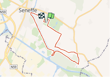
Randonnée Marche nordique de 7,3 km à découvrir à Wallonie, Hainaut, Seneffe. Cette randonnée est proposée par denissculier.
Description
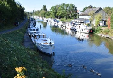
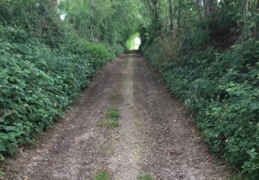
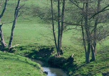
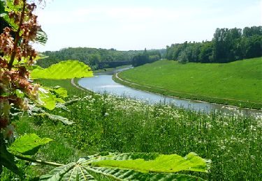
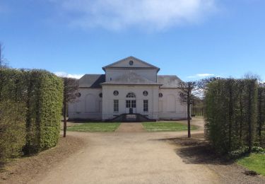
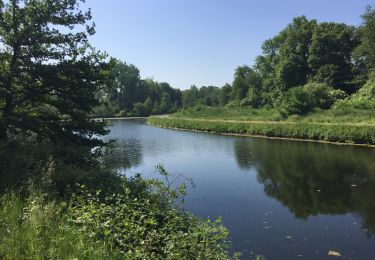
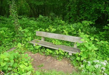
Départ du parking du château pour rejoindre le bois de la Bomerée (tunnel de Godarville) puis longer le chemin de hallage et après l'écluse 14 rejoindre le château par la Drève et enfin arriver au parking.
Localisation
Pays :
Belgique
Région :
Wallonie
Département/Province :
Hainaut
Commune :
Seneffe
Localité :
Seneffe
Départ:(Dec)
Départ:(UTM)
589845 ; 5597745 (31U) N.
Commentaires
Randonnées à proximité
![Randonnée Marche Seneffe - De Arquennes à Monstreux par les vallées de la Thines et de la Samme - Photo](https://media.geolcdn.com/t/375/260/ext.jpg?maxdim=2&url=https%3A%2F%2Fservices.sitytrail.com%2FGeolivesWS%2FDownloadMedia.ashx%3FTrailID%3D127787%26Media%3D79b12576-f9f5-4657-a448-2793aa9c7eb2.JPG)
![Marche Marche](https://static1.geolcdn.com/sitytour/trail-icons/101.png)
De Arquennes à Monstreux par les vallées de la Thines et de la Samme
Marche
Facile
(6)
Seneffe,
Wallonie,
Hainaut,
Belgique
![](/images/other/stat-length.png)
13,7 km | 15,4 km-effort
3h 30min
![](https://static1.geolcdn.com/siteimages/upload/files/16400158638029165_repeat_loop_refresh_sync_direction_icon.png)
Oui
![Randonnée Marche Chapelle-lez-Herlaimont - RL-GG-07_Godarville_Piéton - Photo](https://media.geolcdn.com/t/375/260/98f383e1-513d-40e1-89f6-7cac4611f0b0.jpg&format=jpg&maxdim=2)
![Marche Marche](https://static1.geolcdn.com/sitytour/trail-icons/101.png)
RL-GG-07_Godarville_Piéton
Marche
Très difficile
(4)
Chapelle-lez-Herlaimont,
Wallonie,
Hainaut,
Belgique
![](/images/other/stat-length.png)
18,8 km | 22 km-effort
4h 50min
![](https://static1.geolcdn.com/siteimages/upload/files/16400158638029165_repeat_loop_refresh_sync_direction_icon.png)
Non
![Marche Marche](https://static1.geolcdn.com/sitytour/trail-icons/101.png)
BE-Pont-à-Celles - Autour du ruisseau de Rosseignies
Marche
Facile
(2)
Pont-à-Celles,
Wallonie,
Hainaut,
Belgique
![](/images/other/stat-length.png)
7,6 km | 8,5 km-effort
1h 49min
![](https://static1.geolcdn.com/siteimages/upload/files/16400158638029165_repeat_loop_refresh_sync_direction_icon.png)
Oui
![Randonnée Marche Seneffe - RB-Ha-05 - Feluy - Via allongement - Photo](https://media.geolcdn.com/t/375/260/ext.jpg?maxdim=2&url=https%3A%2F%2Fservices.sitytrail.com%2FGeolivesWS%2FDownloadMedia.ashx%3FTrailID%3D217842%26Media%3D989f0d00-0244-4058-a77e-e5e5f489d7be.jpg)
![Marche Marche](https://static1.geolcdn.com/sitytour/trail-icons/101.png)
RB-Ha-05 - Feluy - Via allongement
Marche
Très difficile
(4)
Seneffe,
Wallonie,
Hainaut,
Belgique
![](/images/other/stat-length.png)
23 km | 26 km-effort
5h 58min
![](https://static1.geolcdn.com/siteimages/upload/files/16400158638029165_repeat_loop_refresh_sync_direction_icon.png)
Oui
![Randonnée Marche Seneffe - RB-Ha-05 - Feluy - Photo](https://media.geolcdn.com/t/375/260/ext.jpg?maxdim=2&url=https%3A%2F%2Fservices.sitytrail.com%2FGeolivesWS%2FDownloadMedia.ashx%3FTrailID%3D179598%26Media%3D989f0d00-0244-4058-a77e-e5e5f489d7be.jpg)
![Marche Marche](https://static1.geolcdn.com/sitytour/trail-icons/101.png)
RB-Ha-05 - Feluy
Marche
Très difficile
(3)
Seneffe,
Wallonie,
Hainaut,
Belgique
![](/images/other/stat-length.png)
22 km | 25 km-effort
5h 39min
![](https://static1.geolcdn.com/siteimages/upload/files/16400158638029165_repeat_loop_refresh_sync_direction_icon.png)
Oui
![Randonnée Marche Seneffe - Balade à Seneffe - Photo](https://media.geolcdn.com/t/375/260/ext.jpg?maxdim=2&url=https%3A%2F%2Fservices.sitytrail.com%2FGeolivesWS%2FDownloadMedia.ashx%3FTrailID%3D130913%26Media%3Daf2f3e93-dc12-469c-a2a0-cc8e44dbe239.JPG)
![Marche Marche](https://static1.geolcdn.com/sitytour/trail-icons/101.png)
Balade à Seneffe
Marche
Facile
(3)
Seneffe,
Wallonie,
Hainaut,
Belgique
![](/images/other/stat-length.png)
11,4 km | 12,9 km-effort
3h 0min
![](https://static1.geolcdn.com/siteimages/upload/files/16400158638029165_repeat_loop_refresh_sync_direction_icon.png)
Oui
![Marche Marche](https://static1.geolcdn.com/sitytour/trail-icons/101.png)
BE-Seneffe - Château de Seneffe - l'Ancien canal
Marche
Moyen
(1)
Seneffe,
Wallonie,
Hainaut,
Belgique
![](/images/other/stat-length.png)
6,6 km | 7,7 km-effort
1h 41min
![](https://static1.geolcdn.com/siteimages/upload/files/16400158638029165_repeat_loop_refresh_sync_direction_icon.png)
Oui
![Randonnée Marche Seneffe - BE-Seneffe - Arquennes - Hameau Les Bois et l'ancien canal - Photo](https://media.geolcdn.com/t/375/260/eb61f70b-cfa0-40f0-88f8-9754f883475d.jpg&format=jpg&maxdim=2)
![Marche Marche](https://static1.geolcdn.com/sitytour/trail-icons/101.png)
BE-Seneffe - Arquennes - Hameau Les Bois et l'ancien canal
Marche
Moyen
(4)
Seneffe,
Wallonie,
Hainaut,
Belgique
![](/images/other/stat-length.png)
8,4 km | 9,5 km-effort
1h 52min
![](https://static1.geolcdn.com/siteimages/upload/files/16400158638029165_repeat_loop_refresh_sync_direction_icon.png)
Oui
![Randonnée Marche nordique Seneffe - De Arquennes à Nivelles par le RAVEl et l'ancien canal - Photo](https://media.geolcdn.com/t/375/260/ext.jpg?maxdim=2&url=https%3A%2F%2Fservices.sitytrail.com%2FGeolivesWS%2FDownloadMedia.ashx%3FTrailID%3D268082%26Media%3Dea1a030b-8c73-4fe5-a6f0-117246010a21.jpg)
![Marche nordique Marche nordique](https://static1.geolcdn.com/sitytour/trail-icons/102.png)
De Arquennes à Nivelles par le RAVEl et l'ancien canal
Marche nordique
Moyen
(2)
Seneffe,
Wallonie,
Hainaut,
Belgique
![](/images/other/stat-length.png)
9,8 km | 11 km-effort
2h 16min
![](https://static1.geolcdn.com/siteimages/upload/files/16400158638029165_repeat_loop_refresh_sync_direction_icon.png)
Oui