Randonnée V.T.T. Loreux - canal de la sauldres - Photo
 lagardienne
lagardienne

Utilisateur

© OpenStreetMap contributors
Longueur
Longueur
104 km
Altitude max
Altitude max
257 m
Dénivelé positif
Dénivelé positif
806 m
Km-Effort
Km-Effort  
114 km
Altitude min
Altitude min
94 m
Dénivelé négatif
Dénivelé négatif
775 m
Boucle
Boucle
Non
Date de création :
2015-10-17 00:00:00.0
Dernière modification :
2015-10-17 00:00:00.0

(0 Avis)

V.T.T.
V.T.T.
12h05
Difficulté : Moyen

Scannez ce code QR pour ouvrir la randonnée dans l'application SityTrail

Application GPS de randonnée GRATUITE

Logo SityTrail SityTrail

IGN / Instituts géographiques

Télécharger SityTrail sur l'App Store Télécharger SityTrail sur Google Play

Logo SityTrail SityTrail World

Le monde est à vous

Télécharger SityTrail sur l'App Store Télécharger SityTrail sur Google Play Télécharger SityTrail sur Huawei AppGallery

À propos

Randonnée V.T.T. de 104 km à découvrir à Centre-Val de Loire, Loir-et-Cher, Loreux. Cette randonnée est proposée par lagardienne.

Description

fait avec un VTT der 35 kg environ.

Profil altimétrique

Photos

Localisation

Pays :
France
Région :
Centre-Val de Loire
Département/Province :
Loir-et-Cher
Commune :
Loreux
Localité :
Unknown
Départ:(Dec)
Départ:(UTM)
412035 ; 5250153 (31T) N.

Randonnées à proximité

Randonnée Vélo Loreux - La route des étangs - Photo
Vélo
lagardienne

Vélo

Très facile
Loreux, Centre-Val de Loire, Loir-et-Cher, France
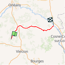
38 km | 42 km-effort
1h 51min
Oui
Randonnée Vélo de route Romorantin-Lanthenay - romo marcilly romo  - Photo
Vélo de route
mimilolo

Vélo de route

Très facile
Romorantin-Lanthenay, Centre-Val de Loire, Loir-et-Cher, France
40 km | 44 km-effort
1h 48min
Oui
Randonnée Marche Villeherviers - villeherviers - Photo
Marche
lecmic

Marche

Facile
Villeherviers, Centre-Val de Loire, Loir-et-Cher, France
7,8 km | 8,5 km-effort
1h 51min
Oui
Randonnée Marche Villeherviers - villeherviers - Photo
Marche
lecmic

Marche

Très facile
Villeherviers, Centre-Val de Loire, Loir-et-Cher, France
7,2 km | 7,8 km-effort
1h 53min
Oui
Randonnée Moto Loreux - GTA 2018 - ETAPE 1 - Photo
Moto
lagardienne

Moto

Facile
Loreux, Centre-Val de Loire, Loir-et-Cher, France
503 km | 586 km-effort
7h 40min
Non
Randonnée V.T.T. Loreux - loreux guerigny - Photo
V.T.T.
lagardienne

V.T.T.

Moyen
Loreux, Centre-Val de Loire, Loir-et-Cher, France
130 km | 147 km-effort
8h 53min
Non
Randonnée Vélo Romorantin-Lanthenay - romo menetou romo - Photo
Vélo
mimilolo

Vélo

Très facile
Romorantin-Lanthenay, Centre-Val de Loire, Loir-et-Cher, France
36 km | 40 km-effort
2h 0min
Oui
Randonnée Vélo de route Romorantin-Lanthenay - romo loreux salbris rte teillay ferthe Imbault romo - Photo
Vélo de route
mimilolo

Vélo de route

Très facile
Romorantin-Lanthenay, Centre-Val de Loire, Loir-et-Cher, France
57 km | 63 km-effort
2h 10min
Oui
Randonnée Vélo de route Romorantin-Lanthenay - Romo Pruniers Mur Courmemin Veillens Romo - Photo
Vélo de route
mimilolo

Vélo de route

Très facile
Romorantin-Lanthenay, Centre-Val de Loire, Loir-et-Cher, France
62 km | 68 km-effort
2h 30min
Oui


Fermer
Mes abonnements