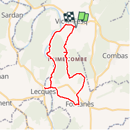
![](/images/other/stat-length.png)
![Randonnée Marche Vic-le-Fesq - 30 VIC-LE-FESQ - le VIDOURLE - LECQUES - FONTANES - ND de PRIME COMBE - Photo](https://media.geolcdn.com/t/1900/400/ext.pjpeg?maxdim=2&url=https%3A%2F%2Fservices.sitytrail.com%2FGeolivesWS%2FDownloadMedia.ashx%3FTrailID%3D459675%26Media%3D20150816093235.jpg)
30 VIC-LE-FESQ - le VIDOURLE - LECQUES - FONTANES - ND de PRIME COMBE
jeff66
Utilisateur
![Longueur](/images/other/stat-length.png)
![Altitude max](https://static1.geolcdn.com/siteimages/upload/files/1508320355ic_sort_altitude_max_24dp.png)
![Dénivelé positif](https://static1.geolcdn.com/siteimages/upload/files/1508320355ic_sort_den_pos_24dp.png)
![Km-Effort](/images/other/stat-length.png)
![Altitude min](https://static1.geolcdn.com/siteimages/upload/files/1508320355ic_sort_altitude_min_24dp.png)
![Dénivelé négatif](https://static1.geolcdn.com/siteimages/upload/files/1508320355ic_sort_den_neg_24dp.png)
![Boucle](https://static1.geolcdn.com/siteimages/upload/files/16400158638029165_repeat_loop_refresh_sync_direction_icon.png)
![Marche](https://static1.geolcdn.com/sitytour/trail-icons/101.png)
2h41
Difficulté : Moyen
![Scannez ce code QR pour ouvrir la randonnée dans l'application SityTrail](https://capi.geolives.com/qq0zvz2zws4bq2lad0pu/sitytour/trails/459675/qr.png?size=200)
Application GPS de randonnée GRATUITE
À propos
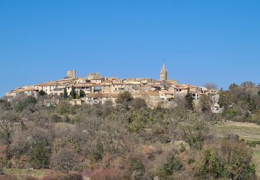
Randonnée Marche de 15 km à découvrir à Occitanie, Gard, Vic-le-Fesq. Cette randonnée est proposée par jeff66.
Description
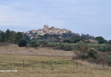
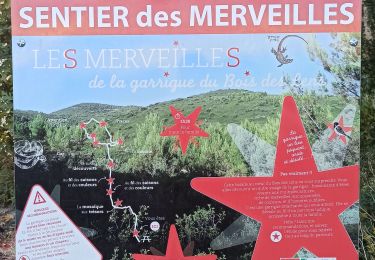
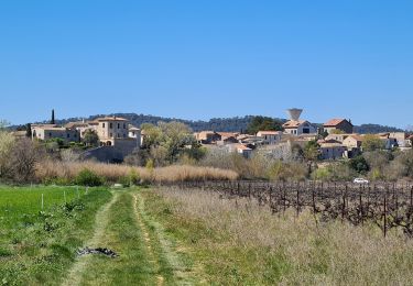
30 VIC-LE-FESQ - longer ancienne voie ferrée désaffectée - bergerie de Coucedière - moulin de Loriol - Bois de beau Crose - le VIDOURLE - bois de Puech grand - le moulin vieux - P.mas de Barret - LECQUES, le pont - D164 - FONTANES, la Condamine, la Fraissinette,ch. de LECQUES, place du temple, rue de Brié - D164 - ruisseau le Brié - piste DFCI C27 - la Roque - bergerie de Glaizes - pisté DFCI C13 - la réserve - D302 - ND de PRIME COMBE - Piste DFCI C26 - croix - VIC-LE-FESQ, ch. de PRIME COMBE, ch. de la tuilerie
Localisation
Commentaires
Randonnées à proximité
![Randonnée Marche Fontanès - FONTANÉS 30 - SALINELLES - PONDRES - ballade autour du Vidourle - Photo](https://media.geolcdn.com/t/375/260/ext.jpg?maxdim=2&url=https%3A%2F%2Fservices.sitytrail.com%2FGeolivesWS%2FDownloadMedia.ashx%3FTrailID%3D446731%26Media%3D20150718095958.jpg)
![Marche Marche](https://static1.geolcdn.com/sitytour/trail-icons/101.png)
Marche
![](/images/other/stat-length.png)
![](https://static1.geolcdn.com/siteimages/upload/files/16400158638029165_repeat_loop_refresh_sync_direction_icon.png)
![Randonnée Marche Orthoux-Sérignac-Quilhan - Sérignac - les Mazes - Bragassargues - Photo](https://media.geolcdn.com/t/375/260/ext.jpg?maxdim=2&url=https%3A%2F%2Fstatic1.geolcdn.com%2Fsiteimages%2Fupload%2Ffiles%2F1553511878bg_sport_marche.png)
![Marche Marche](https://static1.geolcdn.com/sitytour/trail-icons/101.png)
Marche
![](/images/other/stat-length.png)
![](https://static1.geolcdn.com/siteimages/upload/files/16400158638029165_repeat_loop_refresh_sync_direction_icon.png)
![Randonnée Marche Saint-Clément - Le bois de Paris - Grotte, Table d'orientation, Oppidum - Photo](https://media.geolcdn.com/t/375/260/ext.jpg?maxdim=2&url=https%3A%2F%2Fstatic1.geolcdn.com%2Fsiteimages%2Fupload%2Ffiles%2F1553511878bg_sport_marche.png)
![Marche Marche](https://static1.geolcdn.com/sitytour/trail-icons/101.png)
Marche
![](/images/other/stat-length.png)
![](https://static1.geolcdn.com/siteimages/upload/files/16400158638029165_repeat_loop_refresh_sync_direction_icon.png)
![Randonnée Marche Vic-le-Fesq - Viclefesc_ND_de_la_combe - Photo](https://media.geolcdn.com/t/375/260/255c5ac9-ddd4-4188-8efc-bd87460b25d5.jpg&format=jpg&maxdim=2)
![Marche Marche](https://static1.geolcdn.com/sitytour/trail-icons/101.png)
Marche
![](/images/other/stat-length.png)
![](https://static1.geolcdn.com/siteimages/upload/files/16400158638029165_repeat_loop_refresh_sync_direction_icon.png)
![Randonnée Marche Montmirat - Montmirat-les grottes - Photo](https://media.geolcdn.com/t/375/260/cb8675cb-cb9d-463f-8be5-40f2d8d5a71f.jpg&format=jpg&maxdim=2)
![Marche Marche](https://static1.geolcdn.com/sitytour/trail-icons/101.png)
Marche
![](/images/other/stat-length.png)
![](https://static1.geolcdn.com/siteimages/upload/files/16400158638029165_repeat_loop_refresh_sync_direction_icon.png)
![Randonnée Marche Combas - Combats Montpezat - Photo](https://media.geolcdn.com/t/375/260/a146138a-5c04-4a53-8beb-2b89a3330eb6.jpg&format=jpg&maxdim=2)
![Marche Marche](https://static1.geolcdn.com/sitytour/trail-icons/101.png)
Marche
![](/images/other/stat-length.png)
![](https://static1.geolcdn.com/siteimages/upload/files/16400158638029165_repeat_loop_refresh_sync_direction_icon.png)
![Randonnée Marche Combas - Combas - Photo](https://media.geolcdn.com/t/375/260/02dbc83b-be1c-4bf6-a717-854391d9e59e.jpg&format=jpg&maxdim=2)
![Marche Marche](https://static1.geolcdn.com/sitytour/trail-icons/101.png)
![Randonnée Marche Lecques - lecques-viclefesc-ND-Fontaned - Photo](https://media.geolcdn.com/t/375/260/b9ff38b9-7477-4d3c-99f4-9b90adea2f3c.jpg&format=jpg&maxdim=2)
![Marche Marche](https://static1.geolcdn.com/sitytour/trail-icons/101.png)
Marche
![](/images/other/stat-length.png)
![](https://static1.geolcdn.com/siteimages/upload/files/16400158638029165_repeat_loop_refresh_sync_direction_icon.png)
![Randonnée Marche Combas - Combas-Montpezat - Photo](https://media.geolcdn.com/t/375/260/d031eeb3-5aff-4720-8bbd-559e98553871.jpg&format=jpg&maxdim=2)
![Marche Marche](https://static1.geolcdn.com/sitytour/trail-icons/101.png)