![](/images/other/stat-length.png)
![Randonnée V.T.T. Passy - 2015.08.12 Passy - Lac d'Anterne - Samoëns - Flaine - Luth - Photo](https://media.geolcdn.com/t/1900/400/ext.pjpeg?maxdim=2&url=https%3A%2F%2Fstatic1.geolcdn.com%2Fsiteimages%2Fupload%2Ffiles%2F1524743154velo.jpg)
2015.08.12 Passy - Lac d'Anterne - Samoëns - Flaine - Luth
jrd74
Utilisateur
![Longueur](/images/other/stat-length.png)
![Altitude max](https://static1.geolcdn.com/siteimages/upload/files/1508320355ic_sort_altitude_max_24dp.png)
![Dénivelé positif](https://static1.geolcdn.com/siteimages/upload/files/1508320355ic_sort_den_pos_24dp.png)
![Km-Effort](/images/other/stat-length.png)
![Altitude min](https://static1.geolcdn.com/siteimages/upload/files/1508320355ic_sort_altitude_min_24dp.png)
![Dénivelé négatif](https://static1.geolcdn.com/siteimages/upload/files/1508320355ic_sort_den_neg_24dp.png)
![Boucle](https://static1.geolcdn.com/siteimages/upload/files/16400158638029165_repeat_loop_refresh_sync_direction_icon.png)
![V.T.T.](https://static1.geolcdn.com/sitytour/trail-icons/202.png)
8h40
Difficulté : Inconnu
![Scannez ce code QR pour ouvrir la randonnée dans l'application SityTrail](https://capi.geolives.com/qq0zvz2zws4bq2lad0pu/sitytour/trails/458706/qr.png?size=200)
Application GPS de randonnée GRATUITE
À propos
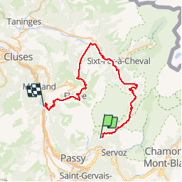
Randonnée V.T.T. de 53 km à découvrir à Auvergne-Rhône-Alpes, Haute-Savoie, Passy. Cette randonnée est proposée par jrd74.
Description
Bus de St Gervais à Passy Plaine-Joux.
Montée au Col d'Anterne.
Descente sur le lac d'Anterne et baignade !
Descente de rêve par les Fonds jusqu'à Salvagny.
Gorges des Tînes et Samoëns.
Remontées TC TS en haut de Samoëns.
Descente et montée en haut des Grands Vans.
Descente jusqu'au lac de Flaine, puis col du Cou, Luth et la route RN1205.
Plutôt que d'attendre le train à Magland (raté pour 10 minutes), retour à St Gervais à vélo (14km à rajouter) ...
Localisation
Commentaires
Randonnées à proximité
![Randonnée Marche Passy - Tour des Ayères - Passy Plaine-Joux - Photo](https://media.geolcdn.com/t/375/260/ext.jpg?maxdim=2&url=https%3A%2F%2Fservices.sitytrail.com%2FGeolivesWS%2FDownloadMedia.ashx%3FTrailID%3D172972%26Media%3D14459_6.jpg)
![Marche Marche](https://static1.geolcdn.com/sitytour/trail-icons/101.png)
Marche
![](/images/other/stat-length.png)
![](https://static1.geolcdn.com/siteimages/upload/files/16400158638029165_repeat_loop_refresh_sync_direction_icon.png)
![Randonnée Marche Passy - J10 - R8 - Plaine Joux - Les Ayères - Lac Vert - Photo](https://media.geolcdn.com/t/375/260/9c4651a9-0301-4065-a6bf-57814595ef3e.jpg&format=jpg&maxdim=2)
![Marche Marche](https://static1.geolcdn.com/sitytour/trail-icons/101.png)
Marche
![](/images/other/stat-length.png)
![](https://static1.geolcdn.com/siteimages/upload/files/16400158638029165_repeat_loop_refresh_sync_direction_icon.png)
![Randonnée Marche Passy - Plaine Joux Barmus Ayères Lac Vert - Photo](https://media.geolcdn.com/t/375/260/231e6d97-0ab1-4400-9dc1-f2b1dbc1d2c1.jpg&format=jpg&maxdim=2)
![Marche Marche](https://static1.geolcdn.com/sitytour/trail-icons/101.png)
Marche
![](/images/other/stat-length.png)
![](https://static1.geolcdn.com/siteimages/upload/files/16400158638029165_repeat_loop_refresh_sync_direction_icon.png)
![Randonnée Marche Passy - Tour de la chaine des Fiz par le passage du Dérochoir - Photo](https://media.geolcdn.com/t/375/260/ext.jpg?maxdim=2&url=https%3A%2F%2Fservices.sitytrail.com%2FGeolivesWS%2FDownloadMedia.ashx%3FTrailID%3D109367%26Media%3D3681_6.jpg)
![Marche Marche](https://static1.geolcdn.com/sitytour/trail-icons/101.png)
Marche
![](/images/other/stat-length.png)
![](https://static1.geolcdn.com/siteimages/upload/files/16400158638029165_repeat_loop_refresh_sync_direction_icon.png)
![Randonnée Marche Passy - Plaine Joux-Passage du derochoir-Col de Portette-Platé - Photo](https://media.geolcdn.com/t/375/260/a1a5c98a-bca0-41f5-b9f9-06d73967e2da.jpg&format=jpg&maxdim=2)
![Marche Marche](https://static1.geolcdn.com/sitytour/trail-icons/101.png)
Marche
![](/images/other/stat-length.png)
![](https://static1.geolcdn.com/siteimages/upload/files/16400158638029165_repeat_loop_refresh_sync_direction_icon.png)
![Randonnée Course à pied Passy - grimpe de chedde ayeres - Photo](https://media.geolcdn.com/t/375/260/ext.jpg?maxdim=2&url=https%3A%2F%2Fstatic1.geolcdn.com%2Fsiteimages%2Fupload%2Ffiles%2F1524743154running.jpg)
![Course à pied Course à pied](https://static1.geolcdn.com/sitytour/trail-icons/103.png)
Course à pied
![](/images/other/stat-length.png)
![](https://static1.geolcdn.com/siteimages/upload/files/16400158638029165_repeat_loop_refresh_sync_direction_icon.png)
![Randonnée Marche Passy - J27 - R25 - 🍂🍁 Plaine-Joux - Les Ayères - Lac Vert 🍁🍂
- Photo](https://media.geolcdn.com/t/375/260/b4952294-3c09-42c8-ac3d-e0aea2d811d5.jpg&format=jpg&maxdim=2)
![Marche Marche](https://static1.geolcdn.com/sitytour/trail-icons/101.png)
Marche
![](/images/other/stat-length.png)
![](https://static1.geolcdn.com/siteimages/upload/files/16400158638029165_repeat_loop_refresh_sync_direction_icon.png)
![Randonnée Marche Les Houches - J21 - R20 - La Fontaine - La Tour St Michel - Photo](https://media.geolcdn.com/t/375/260/41a493fe-e7d9-467b-8687-234bfad2b97b.jpg&format=jpg&maxdim=2)
![Marche Marche](https://static1.geolcdn.com/sitytour/trail-icons/101.png)
Marche
![](/images/other/stat-length.png)
![](https://static1.geolcdn.com/siteimages/upload/files/16400158638029165_repeat_loop_refresh_sync_direction_icon.png)
![Randonnée Marche Sixt-Fer-à-Cheval - Le tour des Fiz : J3 - Photo](https://media.geolcdn.com/t/375/260/9c7228c0-b1d1-422d-97b7-6cc678ab62a3.jpg&format=jpg&maxdim=2)
![Marche Marche](https://static1.geolcdn.com/sitytour/trail-icons/101.png)
Marche
![](/images/other/stat-length.png)
![](https://static1.geolcdn.com/siteimages/upload/files/16400158638029165_repeat_loop_refresh_sync_direction_icon.png)