![](/images/other/stat-length.png)
![Randonnée Marche Vresse-sur-Semois - GR16 Vresse Bouillon - Photo](https://media.geolcdn.com/t/1900/400/ext.pjpeg?maxdim=2&url=https%3A%2F%2Fstatic1.geolcdn.com%2Fsiteimages%2Fupload%2Ffiles%2F1553511878bg_sport_marche.png)
GR16 Vresse Bouillon
mozzipsc
Utilisateur
![Longueur](/images/other/stat-length.png)
Longueur
26 km
![Altitude max](https://static1.geolcdn.com/siteimages/upload/files/1508320355ic_sort_altitude_max_24dp.png)
Altitude max
371 m
![Dénivelé positif](https://static1.geolcdn.com/siteimages/upload/files/1508320355ic_sort_den_pos_24dp.png)
Dénivelé positif
1195 m
![Km-Effort](/images/other/stat-length.png)
Km-Effort
41 km
![Altitude min](https://static1.geolcdn.com/siteimages/upload/files/1508320355ic_sort_altitude_min_24dp.png)
Altitude min
179 m
![Dénivelé négatif](https://static1.geolcdn.com/siteimages/upload/files/1508320355ic_sort_den_neg_24dp.png)
Dénivelé négatif
1156 m
![Boucle](https://static1.geolcdn.com/siteimages/upload/files/16400158638029165_repeat_loop_refresh_sync_direction_icon.png)
Boucle
Non
Date de création :
2015-08-11 00:00:00.0
Dernière modification :
2021-07-25 20:20:50.653
![Marche](https://static1.geolcdn.com/sitytour/trail-icons/101.png)
7h00
Difficulté : Difficile
![Scannez ce code QR pour ouvrir la randonnée dans l'application SityTrail](https://capi.geolives.com/qq0zvz2zws4bq2lad0pu/sitytour/trails/457359/qr.png?size=200)
Application GPS de randonnée GRATUITE
À propos
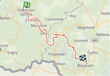
Randonnée Marche de 26 km à découvrir à Wallonie, Namur, Vresse-sur-Semois. Cette randonnée est proposée par mozzipsc.
Description
Très beau parcours (sans doute un des plus beau de Belgique) tout le long de la Semois. Attention certains endroits sont délicats et ne pas avoir trop le vertige.
Localisation
Pays :
Belgique
Région :
Wallonie
Département/Province :
Namur
Commune :
Vresse-sur-Semois
Localité :
Unknown
Départ:(Dec)
Départ:(UTM)
638396 ; 5526352 (31U) N.
Commentaires
Randonnées à proximité
![Marche Marche](https://static1.geolcdn.com/sitytour/trail-icons/101.png)
RB-Na-32_Alle_via-racc
Marche
Très difficile
(2)
Vresse-sur-Semois,
Wallonie,
Namur,
Belgique
![](/images/other/stat-length.png)
14,7 km | 23 km-effort
5h 14min
![](https://static1.geolcdn.com/siteimages/upload/files/16400158638029165_repeat_loop_refresh_sync_direction_icon.png)
Oui
![Marche Marche](https://static1.geolcdn.com/sitytour/trail-icons/101.png)
RB-Na-32_Alle
Marche
Très difficile
(2)
Vresse-sur-Semois,
Wallonie,
Namur,
Belgique
![](/images/other/stat-length.png)
19,8 km | 31 km-effort
7h 5min
![](https://static1.geolcdn.com/siteimages/upload/files/16400158638029165_repeat_loop_refresh_sync_direction_icon.png)
Oui
![Randonnée Marche Vresse-sur-Semois - RB-Na-09_Vresse-sur-Semois_via-var - Photo](https://media.geolcdn.com/t/375/260/ext.jpg?maxdim=2&url=https%3A%2F%2Fservices.sitytrail.com%2FGeolivesWS%2FDownloadMedia.ashx%3FTrailID%3D794164%26Media%3D60b701e1-87e7-4c45-96c1-6064d8879e37.jpg)
![Marche Marche](https://static1.geolcdn.com/sitytour/trail-icons/101.png)
RB-Na-09_Vresse-sur-Semois_via-var
Marche
Moyen
(3)
Vresse-sur-Semois,
Wallonie,
Namur,
Belgique
![](/images/other/stat-length.png)
23 km | 33 km-effort
6h 41min
![](https://static1.geolcdn.com/siteimages/upload/files/16400158638029165_repeat_loop_refresh_sync_direction_icon.png)
Oui
![Randonnée Marche Vresse-sur-Semois - RB-Na-09_Vresse-sur-Semois_via-racc - Photo](https://media.geolcdn.com/t/375/260/ext.jpg?maxdim=2&url=https%3A%2F%2Fservices.sitytrail.com%2FGeolivesWS%2FDownloadMedia.ashx%3FTrailID%3D262313%26Media%3D60b701e1-87e7-4c45-96c1-6064d8879e37.jpg)
![Marche Marche](https://static1.geolcdn.com/sitytour/trail-icons/101.png)
RB-Na-09_Vresse-sur-Semois_via-racc
Marche
Moyen
(2)
Vresse-sur-Semois,
Wallonie,
Namur,
Belgique
![](/images/other/stat-length.png)
17 km | 24 km-effort
5h 7min
![](https://static1.geolcdn.com/siteimages/upload/files/16400158638029165_repeat_loop_refresh_sync_direction_icon.png)
Oui
![Randonnée Marche Vresse-sur-Semois - RB-Na-09_Vresse-sur-Semois - Photo](https://media.geolcdn.com/t/375/260/ext.jpg?maxdim=2&url=https%3A%2F%2Fservices.sitytrail.com%2FGeolivesWS%2FDownloadMedia.ashx%3FTrailID%3D260987%26Media%3Db97841e8-b1a3-4e80-a9b6-aaa2b671bafd.jpg)
![Marche Marche](https://static1.geolcdn.com/sitytour/trail-icons/101.png)
RB-Na-09_Vresse-sur-Semois
Marche
Moyen
(4)
Vresse-sur-Semois,
Wallonie,
Namur,
Belgique
![](/images/other/stat-length.png)
22 km | 32 km-effort
6h 41min
![](https://static1.geolcdn.com/siteimages/upload/files/16400158638029165_repeat_loop_refresh_sync_direction_icon.png)
Oui
![Randonnée Marche Vresse-sur-Semois - La Semois. Natura 2000, des sites qui valent le détour. Na3 - Photo](https://media.geolcdn.com/t/375/260/ext.jpg?maxdim=2&url=https%3A%2F%2Fservices.sitytrail.com%2FGeolivesWS%2FDownloadMedia.ashx%3FTrailID%3D163715%26Media%3Dda40f5b3-1e4b-4509-ae3e-d9dafa1466cc.JPG)
![Marche Marche](https://static1.geolcdn.com/sitytour/trail-icons/101.png)
La Semois. Natura 2000, des sites qui valent le détour. Na3
Marche
Moyen
(3)
Vresse-sur-Semois,
Wallonie,
Namur,
Belgique
![](/images/other/stat-length.png)
13 km | 17,5 km-effort
3h 46min
![](https://static1.geolcdn.com/siteimages/upload/files/16400158638029165_repeat_loop_refresh_sync_direction_icon.png)
Oui
![Randonnée Marche Vresse-sur-Semois - Bohan. Natura 2000, des sites qui valent le détour ! Na2 - Photo](https://media.geolcdn.com/t/375/260/ext.jpg?maxdim=2&url=https%3A%2F%2Fservices.sitytrail.com%2FGeolivesWS%2FDownloadMedia.ashx%3FTrailID%3D161427%26Media%3D5b0af75e-f56d-4b09-8a76-627d51a6ce1b.JPG)
![Marche Marche](https://static1.geolcdn.com/sitytour/trail-icons/101.png)
Bohan. Natura 2000, des sites qui valent le détour ! Na2
Marche
Facile
(1)
Vresse-sur-Semois,
Wallonie,
Namur,
Belgique
![](/images/other/stat-length.png)
4,8 km | 7,8 km-effort
1h 41min
![](https://static1.geolcdn.com/siteimages/upload/files/16400158638029165_repeat_loop_refresh_sync_direction_icon.png)
Oui
![Randonnée Marche Vresse-sur-Semois - Vresse-sur-Semois. Natura 2000, des fiches qui valent le détour ! Na1 - Photo](https://media.geolcdn.com/t/375/260/ext.jpg?maxdim=2&url=https%3A%2F%2Fservices.sitytrail.com%2FGeolivesWS%2FDownloadMedia.ashx%3FTrailID%3D161419%26Media%3D7f9dfac9-cf3f-4279-ae43-0aba8e08a963.JPG)
![Marche Marche](https://static1.geolcdn.com/sitytour/trail-icons/101.png)
Vresse-sur-Semois. Natura 2000, des fiches qui valent le détour ! Na1
Marche
Moyen
(3)
Vresse-sur-Semois,
Wallonie,
Namur,
Belgique
![](/images/other/stat-length.png)
9,3 km | 14 km-effort
2h 56min
![](https://static1.geolcdn.com/siteimages/upload/files/16400158638029165_repeat_loop_refresh_sync_direction_icon.png)
Oui
![Randonnée Marche Vresse-sur-Semois - rando laforêt 6/08/2020 - Photo](https://media.geolcdn.com/t/375/260/a9f0441c-2c35-4081-b504-bd6b06333f46.jpg&format=jpg&maxdim=2)
![Marche Marche](https://static1.geolcdn.com/sitytour/trail-icons/101.png)
rando laforêt 6/08/2020
Marche
Moyen
(1)
Vresse-sur-Semois,
Wallonie,
Namur,
Belgique
![](/images/other/stat-length.png)
14,7 km | 21 km-effort
4h 18min
![](https://static1.geolcdn.com/siteimages/upload/files/16400158638029165_repeat_loop_refresh_sync_direction_icon.png)
Oui
magnifique
Très belle randonnée. Les jambes chauffent vu les dénivelés.