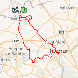
![](/images/other/stat-length.png)
![Randonnée V.T.T. Gembloux - Gembloux - Floreffe - Namur citadelle - Gembloux - Photo](https://media.geolcdn.com/t/1900/400/ext.pjpeg?maxdim=2&url=https%3A%2F%2Fservices.sitytrail.com%2FGeolivesWS%2FDownloadMedia.ashx%3FTrailID%3D453193%26Media%3D20150802162201.jpg)
Gembloux - Floreffe - Namur citadelle - Gembloux
mdd32472790746
Utilisateur
![Longueur](/images/other/stat-length.png)
![Altitude max](https://static1.geolcdn.com/siteimages/upload/files/1508320355ic_sort_altitude_max_24dp.png)
![Dénivelé positif](https://static1.geolcdn.com/siteimages/upload/files/1508320355ic_sort_den_pos_24dp.png)
![Km-Effort](/images/other/stat-length.png)
![Altitude min](https://static1.geolcdn.com/siteimages/upload/files/1508320355ic_sort_altitude_min_24dp.png)
![Dénivelé négatif](https://static1.geolcdn.com/siteimages/upload/files/1508320355ic_sort_den_neg_24dp.png)
![Boucle](https://static1.geolcdn.com/siteimages/upload/files/16400158638029165_repeat_loop_refresh_sync_direction_icon.png)
![V.T.T.](https://static1.geolcdn.com/sitytour/trail-icons/202.png)
3h54
Difficulté : Difficile
![Scannez ce code QR pour ouvrir la randonnée dans l'application SityTrail](https://capi.geolives.com/qq0zvz2zws4bq2lad0pu/sitytour/trails/453193/qr.png?size=200)
Application GPS de randonnée GRATUITE
À propos
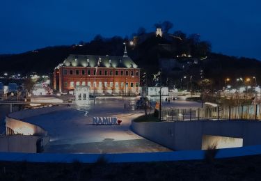
Randonnée V.T.T. de 61 km à découvrir à Wallonie, Namur, Gembloux. Cette randonnée est proposée par mdd32472790746.
Description
Itinéraire fait en été. Très agréable par temps ensoleille maximum 25 degrés. Conseil : partir vers 10 heures pour arrivée à la citadelle maximum à 12h30. Manger son casse croute là bas et profiter de la vue ainsi que de la terrasse Terra Nova jusqu'à 15h00 environ. Ensuite reprendre la route et remonter par saint servais, lonzée par les petits chemins.
Localisation
Commentaires
Randonnées à proximité
![Randonnée Marche Chastre - Promenade de Villeroux - Photo](https://media.geolcdn.com/t/375/260/ext.jpg?maxdim=2&url=https%3A%2F%2Fservices.sitytrail.com%2FGeolivesWS%2FDownloadMedia.ashx%3FTrailID%3D233658%26Media%3D6ce217ee-b2e1-442a-b4a3-34a4ee262c13.JPG)
![Marche Marche](https://static1.geolcdn.com/sitytour/trail-icons/101.png)
Marche
![](/images/other/stat-length.png)
![](https://static1.geolcdn.com/siteimages/upload/files/16400158638029165_repeat_loop_refresh_sync_direction_icon.png)
![Randonnée Marche Chastre - Balade récréative de Cortil - Photo](https://media.geolcdn.com/t/375/260/ext.jpg?maxdim=2&url=https%3A%2F%2Fservices.sitytrail.com%2FGeolivesWS%2FDownloadMedia.ashx%3FTrailID%3D232278%26Media%3D010369e0-b48e-4ca2-9215-837380cbac27.jpg)
![Marche Marche](https://static1.geolcdn.com/sitytour/trail-icons/101.png)
Marche
![](/images/other/stat-length.png)
![](https://static1.geolcdn.com/siteimages/upload/files/16400158638029165_repeat_loop_refresh_sync_direction_icon.png)
![Randonnée Marche Gembloux - Balade de Gembloux à Corroy-le-Château - Photo](https://media.geolcdn.com/t/375/260/8bfe3e44-67e5-4d79-bff4-ef099b232ea5.jpg&format=jpg&maxdim=2)
![Marche Marche](https://static1.geolcdn.com/sitytour/trail-icons/101.png)
Marche
![](/images/other/stat-length.png)
![](https://static1.geolcdn.com/siteimages/upload/files/16400158638029165_repeat_loop_refresh_sync_direction_icon.png)
![Randonnée Marche Chastre - Saint Gery - Namur - par le GR126 - Photo](https://media.geolcdn.com/t/375/260/18f2aab5-a522-40c8-9ccf-e3f0f1d2197a.jpg&format=jpg&maxdim=2)
![Marche Marche](https://static1.geolcdn.com/sitytour/trail-icons/101.png)
Marche
![](/images/other/stat-length.png)
![](https://static1.geolcdn.com/siteimages/upload/files/16400158638029165_repeat_loop_refresh_sync_direction_icon.png)
![Randonnée Marche Gembloux - Gembloux (gare) - Cortil - Chastre - Nil - Walhain - E411 sortie 11 par GR127 - Photo](https://media.geolcdn.com/t/375/260/70607764-bcef-4ec9-9b5f-6048d2579c09.jpg&format=jpg&maxdim=2)
![Marche Marche](https://static1.geolcdn.com/sitytour/trail-icons/101.png)
Marche
![](/images/other/stat-length.png)
![](https://static1.geolcdn.com/siteimages/upload/files/16400158638029165_repeat_loop_refresh_sync_direction_icon.png)
![Randonnée Marche Gembloux - bgg - ernage bertinchamps gentines chastre perbais - Photo](https://media.geolcdn.com/t/375/260/acd4923b-00bd-46a5-bc73-b141f9ba9715.jpg&format=jpg&maxdim=2)
![Marche Marche](https://static1.geolcdn.com/sitytour/trail-icons/101.png)
Marche
![](/images/other/stat-length.png)
![](https://static1.geolcdn.com/siteimages/upload/files/16400158638029165_repeat_loop_refresh_sync_direction_icon.png)
![Marche Marche](https://static1.geolcdn.com/sitytour/trail-icons/101.png)
Marche
![](/images/other/stat-length.png)
![](https://static1.geolcdn.com/siteimages/upload/files/16400158638029165_repeat_loop_refresh_sync_direction_icon.png)
![Randonnée Marche Chastre - gb - chastre grand tour fractionnable - Photo](https://media.geolcdn.com/t/375/260/445a307c-701a-4e90-a82a-45f885f3b381.jpg&format=jpg&maxdim=2)
![Marche Marche](https://static1.geolcdn.com/sitytour/trail-icons/101.png)
Marche
![](/images/other/stat-length.png)
![](https://static1.geolcdn.com/siteimages/upload/files/16400158638029165_repeat_loop_refresh_sync_direction_icon.png)
![Randonnée Marche Gembloux - covid 17-4-20 12 km - Photo](https://media.geolcdn.com/t/375/260/575ef2e1-64c3-47f4-a366-815bffa60540.jpg&format=jpg&maxdim=2)
![Marche Marche](https://static1.geolcdn.com/sitytour/trail-icons/101.png)
Marche
![](/images/other/stat-length.png)
![](https://static1.geolcdn.com/siteimages/upload/files/16400158638029165_repeat_loop_refresh_sync_direction_icon.png)