![](/images/other/stat-length.png)
![Randonnée Marche Saint-Philippe - Jardin des Laves Puits Arabe - Photo](https://media.geolcdn.com/t/1900/400/ext.pjpeg?maxdim=2&url=https%3A%2F%2Fservices.sitytrail.com%2FGeolivesWS%2FDownloadMedia.ashx%3FTrailID%3D452674%26Media%3Dfix__20150724115043.jpg)
Jardin des Laves Puits Arabe
chouchou-slc
Utilisateur
![Longueur](/images/other/stat-length.png)
Longueur
4,3 km
![Altitude max](https://static1.geolcdn.com/siteimages/upload/files/1508320355ic_sort_altitude_max_24dp.png)
Altitude max
26 m
![Dénivelé positif](https://static1.geolcdn.com/siteimages/upload/files/1508320355ic_sort_den_pos_24dp.png)
Dénivelé positif
37 m
![Km-Effort](/images/other/stat-length.png)
Km-Effort
4,8 km
![Altitude min](https://static1.geolcdn.com/siteimages/upload/files/1508320355ic_sort_altitude_min_24dp.png)
Altitude min
5 m
![Dénivelé négatif](https://static1.geolcdn.com/siteimages/upload/files/1508320355ic_sort_den_neg_24dp.png)
Dénivelé négatif
34 m
![Boucle](https://static1.geolcdn.com/siteimages/upload/files/16400158638029165_repeat_loop_refresh_sync_direction_icon.png)
Boucle
Oui
Date de création :
2016-03-09 00:00:00.0
Dernière modification :
2016-03-09 00:00:00.0
![Marche](https://static1.geolcdn.com/sitytour/trail-icons/101.png)
1h44
Difficulté : Facile
![Scannez ce code QR pour ouvrir la randonnée dans l'application SityTrail](https://capi.geolives.com/qq0zvz2zws4bq2lad0pu/sitytour/trails/452674/qr.png?size=200)
Application GPS de randonnée GRATUITE
À propos
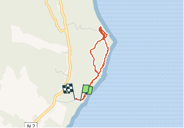
Randonnée Marche de 4,3 km à découvrir à La Réunion, Inconnu, Saint-Philippe. Cette randonnée est proposée par chouchou-slc.
Description
ballade sur les laves Pointe de la Table
Localisation
Pays :
France
Région :
La Réunion
Département/Province :
Inconnu
Commune :
Saint-Philippe
Localité :
Unknown
Départ:(Dec)
Départ:(UTM)
375928 ; 7639737 (40K) S.
Commentaires
Randonnées à proximité
![Randonnée Marche Saint-Philippe - chasse - Photo](https://media.geolcdn.com/t/375/260/ext.jpg?maxdim=2&url=https%3A%2F%2Fstatic1.geolcdn.com%2Fsiteimages%2Fupload%2Ffiles%2F1553511878bg_sport_marche.png)
![Marche Marche](https://static1.geolcdn.com/sitytour/trail-icons/101.png)
chasse
Marche
Moyen
Saint-Philippe,
La Réunion,
Inconnu,
France
![](/images/other/stat-length.png)
5,8 km | 10,1 km-effort
8h 21min
![](https://static1.geolcdn.com/siteimages/upload/files/16400158638029165_repeat_loop_refresh_sync_direction_icon.png)
Non
![Randonnée Marche Saint-Philippe - Route forestière takamaka et descente vers la pointe de la table - Photo](https://media.geolcdn.com/t/375/260/ext.jpg?maxdim=2&url=https%3A%2F%2Fstatic1.geolcdn.com%2Fsiteimages%2Fupload%2Ffiles%2F1553511878bg_sport_marche.png)
![Marche Marche](https://static1.geolcdn.com/sitytour/trail-icons/101.png)
Route forestière takamaka et descente vers la pointe de la table
Marche
Moyen
Saint-Philippe,
La Réunion,
Inconnu,
France
![](/images/other/stat-length.png)
11,9 km | 16,7 km-effort
3h 37min
![](https://static1.geolcdn.com/siteimages/upload/files/16400158638029165_repeat_loop_refresh_sync_direction_icon.png)
Oui
![Randonnée Marche Saint-Philippe - Caverne des gendarmes - Photo](https://media.geolcdn.com/t/375/260/ext.jpg?maxdim=2&url=https%3A%2F%2Fstatic1.geolcdn.com%2Fsiteimages%2Fupload%2Ffiles%2F1553511878bg_sport_marche.png)
![Marche Marche](https://static1.geolcdn.com/sitytour/trail-icons/101.png)
Caverne des gendarmes
Marche
Facile
Saint-Philippe,
La Réunion,
Inconnu,
France
![](/images/other/stat-length.png)
3,1 km | 4,3 km-effort
57min
![](https://static1.geolcdn.com/siteimages/upload/files/16400158638029165_repeat_loop_refresh_sync_direction_icon.png)
Oui
![Randonnée Autre activité Saint-Philippe - tanaka - Photo](https://media.geolcdn.com/t/375/260/ext.jpg?maxdim=2&url=https%3A%2F%2Fstatic1.geolcdn.com%2Fsiteimages%2Fupload%2Ffiles%2F1545311037marcheuse_200dpi.jpg)
![Autre activité Autre activité](https://static1.geolcdn.com/sitytour/trail-icons/900.png)
tanaka
Autre activité
Très facile
Saint-Philippe,
La Réunion,
Inconnu,
France
![](/images/other/stat-length.png)
4,3 km | 13,6 km-effort
2h 0min
![](https://static1.geolcdn.com/siteimages/upload/files/16400158638029165_repeat_loop_refresh_sync_direction_icon.png)
Non
![Randonnée sport Saint-Philippe - 2024-10-12_17h09m57_Randopitons Itineraire #1433 - Tour Takamaka Rf Takamaka Littoral Pointe Table - Photo](https://media.geolcdn.com/t/375/260/ext.jpg?maxdim=2&url=https%3A%2F%2Fsecurestorage.geolives.com%2Fsitytour%2Ftrail-bg%2Fdefault.jpg)
2024-10-12_17h09m57_Randopitons Itineraire #1433 - Tour Takamaka Rf Takamaka ...
sport
Très facile
(1)
Saint-Philippe,
La Réunion,
Inconnu,
France
![](/images/other/stat-length.png)
11,8 km | 16,6 km-effort
Inconnu
![](https://static1.geolcdn.com/siteimages/upload/files/16400158638029165_repeat_loop_refresh_sync_direction_icon.png)
Oui
![Randonnée Vélo de route Saint-Philippe - st Philippe - l'étang salé par ma plaine des palmistes - Photo](https://media.geolcdn.com/t/375/260/ext.jpg?maxdim=2&url=https%3A%2F%2Fstatic1.geolcdn.com%2Fsiteimages%2Fupload%2Ffiles%2F1524743154velo.jpg)
![Vélo de route Vélo de route](https://static1.geolcdn.com/sitytour/trail-icons/201.png)
st Philippe - l'étang salé par ma plaine des palmistes
Vélo de route
Moyen
Saint-Philippe,
La Réunion,
Inconnu,
France
![](/images/other/stat-length.png)
118 km | 151 km-effort
9h 45min
![](https://static1.geolcdn.com/siteimages/upload/files/16400158638029165_repeat_loop_refresh_sync_direction_icon.png)
Non
![Randonnée Marche Saint-Philippe - Pointe table_Tremblet - Photo](https://media.geolcdn.com/t/375/260/ext.jpg?maxdim=2&url=https%3A%2F%2Fstatic1.geolcdn.com%2Fsiteimages%2Fupload%2Ffiles%2F1553511878bg_sport_marche.png)
![Marche Marche](https://static1.geolcdn.com/sitytour/trail-icons/101.png)
Pointe table_Tremblet
Marche
Très facile
Saint-Philippe,
La Réunion,
Inconnu,
France
![](/images/other/stat-length.png)
13,7 km | 17,3 km-effort
4h 41min
![](https://static1.geolcdn.com/siteimages/upload/files/16400158638029165_repeat_loop_refresh_sync_direction_icon.png)
Oui
![Randonnée Marche Saint-Philippe - Mer cassée _ Pointe de la table - Photo](https://media.geolcdn.com/t/375/260/ext.jpg?maxdim=2&url=https%3A%2F%2Fstatic1.geolcdn.com%2Fsiteimages%2Fupload%2Ffiles%2F1553511878bg_sport_marche.png)
![Marche Marche](https://static1.geolcdn.com/sitytour/trail-icons/101.png)
Mer cassée _ Pointe de la table
Marche
Très facile
Saint-Philippe,
La Réunion,
Inconnu,
France
![](/images/other/stat-length.png)
17,4 km | 20 km-effort
6h 51min
![](https://static1.geolcdn.com/siteimages/upload/files/16400158638029165_repeat_loop_refresh_sync_direction_icon.png)
Oui
Parcours barré (propriété privée défense d’entrer)