![](/images/other/stat-length.png)
Ségur-le-Château-Sentier botanique
houbart
Utilisateur
![Longueur](/images/other/stat-length.png)
Longueur
3,8 km
![Altitude max](https://static1.geolcdn.com/siteimages/upload/files/1508320355ic_sort_altitude_max_24dp.png)
Altitude max
345 m
![Dénivelé positif](https://static1.geolcdn.com/siteimages/upload/files/1508320355ic_sort_den_pos_24dp.png)
Dénivelé positif
115 m
![Km-Effort](/images/other/stat-length.png)
Km-Effort
5,3 km
![Altitude min](https://static1.geolcdn.com/siteimages/upload/files/1508320355ic_sort_altitude_min_24dp.png)
Altitude min
271 m
![Dénivelé négatif](https://static1.geolcdn.com/siteimages/upload/files/1508320355ic_sort_den_neg_24dp.png)
Dénivelé négatif
120 m
![Boucle](https://static1.geolcdn.com/siteimages/upload/files/16400158638029165_repeat_loop_refresh_sync_direction_icon.png)
Boucle
Oui
Date de création :
2019-03-28 15:47:29.618
Dernière modification :
2019-03-28 15:47:29.668
![Marche](https://static1.geolcdn.com/sitytour/trail-icons/101.png)
1h00
Difficulté : Facile
![Scannez ce code QR pour ouvrir la randonnée dans l'application SityTrail](https://capi.geolives.com/qq0zvz2zws4bq2lad0pu/sitytour/trails/451734/qr.png?size=200)
Application GPS de randonnée GRATUITE
À propos
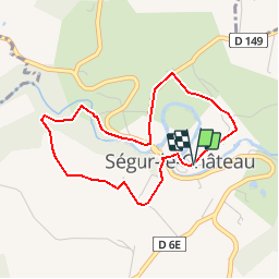
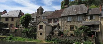
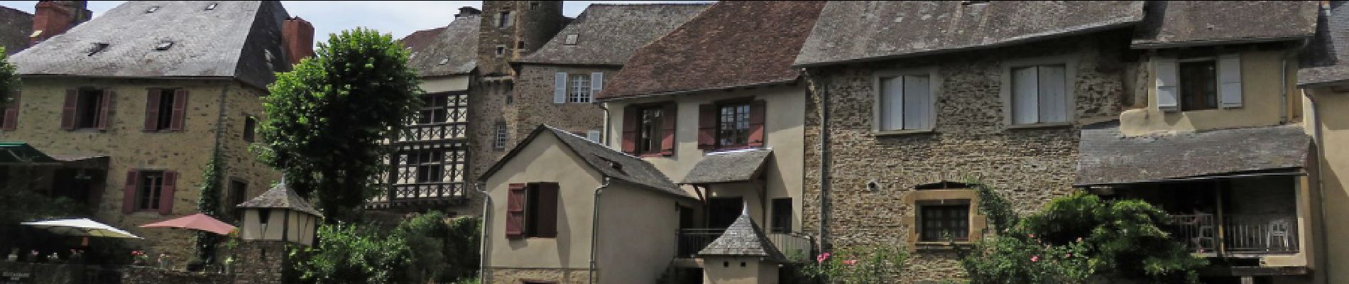
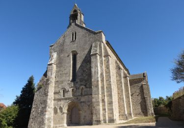
Randonnée Marche de 3,8 km à découvrir à Nouvelle-Aquitaine, Corrèze, Ségur-le-Château. Cette randonnée est proposée par houbart.
Description
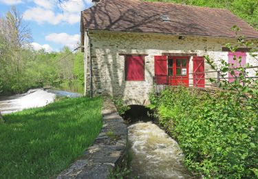
Départ du village, un des "plus beaux villages de France". Le sentier botanique a beaucoup souffert et ne présente pas grand intérêt. La balade est agréable, à l'ombre des sous-bois.
Localisation
Pays :
France
Région :
Nouvelle-Aquitaine
Département/Province :
Corrèze
Commune :
Ségur-le-Château
Localité :
Unknown
Départ:(Dec)
Départ:(UTM)
367506 ; 5031983 (31T) N.
Commentaires
Randonnées à proximité
![Randonnée Marche Beyssenac - Beyssenac - Moulin de la papeterie - Photo](https://media.geolcdn.com/t/375/260/90f368d3-9ce8-4b95-9841-bbcf566513e6.jpg&format=jpg&maxdim=2)
![Marche Marche](https://static1.geolcdn.com/sitytour/trail-icons/101.png)
Beyssenac - Moulin de la papeterie
Marche
Très facile
Beyssenac,
Nouvelle-Aquitaine,
Corrèze,
France
![](/images/other/stat-length.png)
9,1 km | 11,4 km-effort
2h 25min
![](https://static1.geolcdn.com/siteimages/upload/files/16400158638029165_repeat_loop_refresh_sync_direction_icon.png)
Oui
![Randonnée Marche Arnac-Pompadour - Arnac-Pompadour- Domaine de Chignac - Photo](https://media.geolcdn.com/t/375/260/ext.jpg?maxdim=2&url=https%3A%2F%2Fservices.sitytrail.com%2FGeolivesWS%2FDownloadMedia.ashx%3FTrailID%3D1049035%26Media%3D0c13fd81-6631-4747-8c52-1d414983a134.JPG)
![Marche Marche](https://static1.geolcdn.com/sitytour/trail-icons/101.png)
Arnac-Pompadour- Domaine de Chignac
Marche
Facile
Arnac-Pompadour,
Nouvelle-Aquitaine,
Corrèze,
France
![](/images/other/stat-length.png)
6,2 km | 7,7 km-effort
1h 43min
![](https://static1.geolcdn.com/siteimages/upload/files/16400158638029165_repeat_loop_refresh_sync_direction_icon.png)
Oui
![Randonnée Marche Beyssenac - Les 7 étangs autour de Beyssenac - Photo](https://media.geolcdn.com/t/375/260/ext.jpg?maxdim=2&url=https%3A%2F%2Fstatic1.geolcdn.com%2Fsiteimages%2Fupload%2Ffiles%2F1553511878bg_sport_marche.png)
![Marche Marche](https://static1.geolcdn.com/sitytour/trail-icons/101.png)
Les 7 étangs autour de Beyssenac
Marche
Moyen
(1)
Beyssenac,
Nouvelle-Aquitaine,
Corrèze,
France
![](/images/other/stat-length.png)
7,3 km | 8,5 km-effort
1h 51min
![](https://static1.geolcdn.com/siteimages/upload/files/16400158638029165_repeat_loop_refresh_sync_direction_icon.png)
Oui
![Randonnée Marche Arnac-Pompadour - Arnac- Forêt domaniale d'Arnac-Pompadour - Photo](https://media.geolcdn.com/t/375/260/ext.jpg?maxdim=2&url=https%3A%2F%2Fstatic1.geolcdn.com%2Fsiteimages%2Fupload%2Ffiles%2F1553511878bg_sport_marche.png)
![Marche Marche](https://static1.geolcdn.com/sitytour/trail-icons/101.png)
Arnac- Forêt domaniale d'Arnac-Pompadour
Marche
Très facile
Arnac-Pompadour,
Nouvelle-Aquitaine,
Corrèze,
France
![](/images/other/stat-length.png)
6,9 km | 8,9 km-effort
1h 54min
![](https://static1.geolcdn.com/siteimages/upload/files/16400158638029165_repeat_loop_refresh_sync_direction_icon.png)
Oui
![Randonnée Marche Arnac-Pompadour - Arnac-Pompadour- les levades - Photo](https://media.geolcdn.com/t/375/260/ext.jpg?maxdim=2&url=https%3A%2F%2Fstatic1.geolcdn.com%2Fsiteimages%2Fupload%2Ffiles%2F1553511878bg_sport_marche.png)
![Marche Marche](https://static1.geolcdn.com/sitytour/trail-icons/101.png)
Arnac-Pompadour- les levades
Marche
Très facile
Arnac-Pompadour,
Nouvelle-Aquitaine,
Corrèze,
France
![](/images/other/stat-length.png)
6,6 km | 8,9 km-effort
1h 53min
![](https://static1.geolcdn.com/siteimages/upload/files/16400158638029165_repeat_loop_refresh_sync_direction_icon.png)
Oui
![Randonnée Marche Ségur-le-Château - Ségur-le-Château, berceau des Vicomtes de Limoges - Photo](https://media.geolcdn.com/t/375/260/ext.jpg?maxdim=2&url=https%3A%2F%2Fstatic1.geolcdn.com%2Fsiteimages%2Fupload%2Ffiles%2F1553511878bg_sport_marche.png)
![Marche Marche](https://static1.geolcdn.com/sitytour/trail-icons/101.png)
Ségur-le-Château, berceau des Vicomtes de Limoges
Marche
Très facile
Ségur-le-Château,
Nouvelle-Aquitaine,
Corrèze,
France
![](/images/other/stat-length.png)
3,1 km | 4,2 km-effort
58min
![](https://static1.geolcdn.com/siteimages/upload/files/16400158638029165_repeat_loop_refresh_sync_direction_icon.png)
Oui
![Randonnée sport Ségur-le-Château - Ségur le château - Photo](https://media.geolcdn.com/t/375/260/ext.jpg?maxdim=2&url=https%3A%2F%2Fsecurestorage.geolives.com%2Fsitytour%2Ftrail-bg%2Fdefault.jpg)
Ségur le château
sport
Très facile
Ségur-le-Château,
Nouvelle-Aquitaine,
Corrèze,
France
![](/images/other/stat-length.png)
7,1 km | 9,4 km-effort
Inconnu
![](https://static1.geolcdn.com/siteimages/upload/files/16400158638029165_repeat_loop_refresh_sync_direction_icon.png)
Non
![Randonnée Marche Beyssenac - Beyssenac - Ruisseau des belles dames - Photo](https://media.geolcdn.com/t/375/260/ext.jpg?maxdim=2&url=https%3A%2F%2Fstatic1.geolcdn.com%2Fsiteimages%2Fupload%2Ffiles%2F1553511878bg_sport_marche.png)
![Marche Marche](https://static1.geolcdn.com/sitytour/trail-icons/101.png)
Beyssenac - Ruisseau des belles dames
Marche
Difficile
Beyssenac,
Nouvelle-Aquitaine,
Corrèze,
France
![](/images/other/stat-length.png)
10,7 km | 12,9 km-effort
2h 48min
![](https://static1.geolcdn.com/siteimages/upload/files/16400158638029165_repeat_loop_refresh_sync_direction_icon.png)
Oui
![Randonnée Marche Beyssenac - Beyssenac - Germiniac - Photo](https://media.geolcdn.com/t/375/260/ext.jpg?maxdim=2&url=https%3A%2F%2Fstatic1.geolcdn.com%2Fsiteimages%2Fupload%2Ffiles%2F1553511878bg_sport_marche.png)
![Marche Marche](https://static1.geolcdn.com/sitytour/trail-icons/101.png)
Beyssenac - Germiniac
Marche
Moyen
Beyssenac,
Nouvelle-Aquitaine,
Corrèze,
France
![](/images/other/stat-length.png)
8,1 km | 9,6 km-effort
2h 8min
![](https://static1.geolcdn.com/siteimages/upload/files/16400158638029165_repeat_loop_refresh_sync_direction_icon.png)
Oui