![](/images/other/stat-length.png)
![Randonnée V.T.T. Chiny - B.Izel11A59km870mVTC - Photo](https://media.geolcdn.com/t/1900/400/ext.pjpeg?maxdim=2&url=https%3A%2F%2Fstatic1.geolcdn.com%2Fsiteimages%2Fupload%2Ffiles%2F1524743154velo.jpg)
B.Izel11A59km870mVTC
francois58
Utilisateur
![Longueur](/images/other/stat-length.png)
Longueur
59 km
![Altitude max](https://static1.geolcdn.com/siteimages/upload/files/1508320355ic_sort_altitude_max_24dp.png)
Altitude max
382 m
![Dénivelé positif](https://static1.geolcdn.com/siteimages/upload/files/1508320355ic_sort_den_pos_24dp.png)
Dénivelé positif
1035 m
![Km-Effort](/images/other/stat-length.png)
Km-Effort
73 km
![Altitude min](https://static1.geolcdn.com/siteimages/upload/files/1508320355ic_sort_altitude_min_24dp.png)
Altitude min
182 m
![Dénivelé négatif](https://static1.geolcdn.com/siteimages/upload/files/1508320355ic_sort_den_neg_24dp.png)
Dénivelé négatif
1034 m
![Boucle](https://static1.geolcdn.com/siteimages/upload/files/16400158638029165_repeat_loop_refresh_sync_direction_icon.png)
Boucle
Oui
Date de création :
2017-06-19 00:00:00.0
Dernière modification :
2017-06-19 00:00:00.0
![V.T.T.](https://static1.geolcdn.com/sitytour/trail-icons/202.png)
4h40
Difficulté : Facile
![Scannez ce code QR pour ouvrir la randonnée dans l'application SityTrail](https://capi.geolives.com/qq0zvz2zws4bq2lad0pu/sitytour/trails/450641/qr.png?size=200)
Application GPS de randonnée GRATUITE
À propos
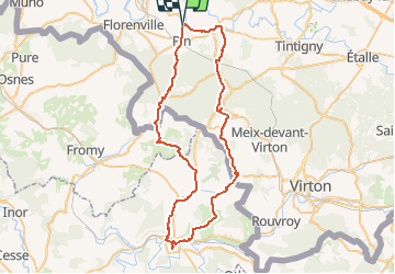
Randonnée V.T.T. de 59 km à découvrir à Wallonie, Luxembourg, Chiny. Cette randonnée est proposée par francois58.
Description
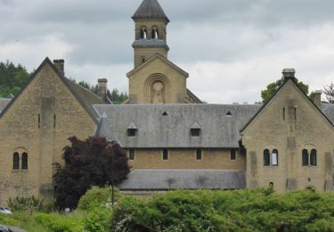
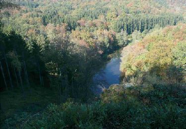
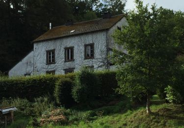
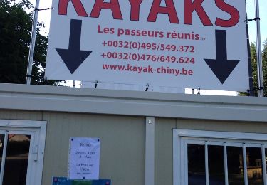
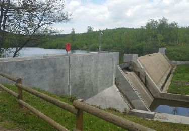
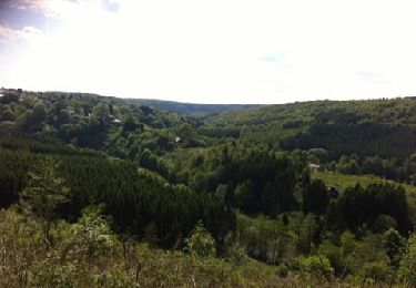
Très belle randonnée franco-belge. 1/3 forêt - 2/3 campagne. 2/3 macadam - 1/3 chemins empierrés. On pourra admirer l'Abbaye d'Orval, la Basilique d'Avioth, la Citadelle de Montmédy et de nombreux villages bien sympas !
Localisation
Pays :
Belgique
Région :
Wallonie
Département/Province :
Luxembourg
Commune :
Chiny
Localité :
Izel
Départ:(Dec)
Départ:(UTM)
671085 ; 5507780 (31U) N.
Commentaires
Randonnées à proximité
![Marche Marche](https://static1.geolcdn.com/sitytour/trail-icons/101.png)
RB-Lu-19_Chameleux_via-racc-2
Marche
Très facile
(2)
Florenville,
Wallonie,
Luxembourg,
Belgique
![](/images/other/stat-length.png)
18 km | 22 km-effort
4h 43min
![](https://static1.geolcdn.com/siteimages/upload/files/16400158638029165_repeat_loop_refresh_sync_direction_icon.png)
Oui
![Randonnée Marche Florenville - RB-Lu-14_Lacuisine_via-racc - Photo](https://media.geolcdn.com/t/375/260/ext.jpg?maxdim=2&url=https%3A%2F%2Fservices.sitytrail.com%2FGeolivesWS%2FDownloadMedia.ashx%3FTrailID%3D216822%26Media%3D4ddebe42-f4ef-4430-a594-18137c26d0fd.jpg)
![Marche Marche](https://static1.geolcdn.com/sitytour/trail-icons/101.png)
RB-Lu-14_Lacuisine_via-racc
Marche
Très difficile
(2)
Florenville,
Wallonie,
Luxembourg,
Belgique
![](/images/other/stat-length.png)
19,9 km | 25 km-effort
5h 34min
![](https://static1.geolcdn.com/siteimages/upload/files/16400158638029165_repeat_loop_refresh_sync_direction_icon.png)
Oui
![Randonnée Marche Florenville - RB-Lu-14_Lacuisine - Photo](https://media.geolcdn.com/t/375/260/ext.jpg?maxdim=2&url=https%3A%2F%2Fservices.sitytrail.com%2FGeolivesWS%2FDownloadMedia.ashx%3FTrailID%3D179620%26Media%3D4ddebe42-f4ef-4430-a594-18137c26d0fd.jpg)
![Marche Marche](https://static1.geolcdn.com/sitytour/trail-icons/101.png)
RB-Lu-14_Lacuisine
Marche
Moyen
(4)
Florenville,
Wallonie,
Luxembourg,
Belgique
![](/images/other/stat-length.png)
24 km | 31 km-effort
6h 8min
![](https://static1.geolcdn.com/siteimages/upload/files/16400158638029165_repeat_loop_refresh_sync_direction_icon.png)
Oui
![Randonnée Marche Chiny - Semois, rochers et étangs - Photo](https://media.geolcdn.com/t/375/260/aad7bb70-f961-4423-a769-93d92e58c39f.jpg&format=jpg&maxdim=2)
![Marche Marche](https://static1.geolcdn.com/sitytour/trail-icons/101.png)
Semois, rochers et étangs
Marche
Difficile
(2)
Chiny,
Wallonie,
Luxembourg,
Belgique
![](/images/other/stat-length.png)
14,8 km | 19,4 km-effort
2h 41min
![](https://static1.geolcdn.com/siteimages/upload/files/16400158638029165_repeat_loop_refresh_sync_direction_icon.png)
Oui
![Randonnée Marche Chiny - Le long de la semois et sur les crêtes de Chiny - Photo](https://media.geolcdn.com/t/375/260/ext.jpg?maxdim=2&url=https%3A%2F%2Fservices.sitytrail.com%2FGeolivesWS%2FDownloadMedia.ashx%3FTrailID%3D453275%26Media%3D20150802184840.jpg)
![Marche Marche](https://static1.geolcdn.com/sitytour/trail-icons/101.png)
Le long de la semois et sur les crêtes de Chiny
Marche
Très facile
(1)
Chiny,
Wallonie,
Luxembourg,
Belgique
![](/images/other/stat-length.png)
6,7 km | 8,3 km-effort
1h 53min
![](https://static1.geolcdn.com/siteimages/upload/files/16400158638029165_repeat_loop_refresh_sync_direction_icon.png)
Oui
![Randonnée Marche Chiny - Autour de la forêt de Chiny - Photo](https://media.geolcdn.com/t/375/260/ext.jpg?maxdim=2&url=https%3A%2F%2Fservices.sitytrail.com%2FGeolivesWS%2FDownloadMedia.ashx%3FTrailID%3D422130%26Media%3Dfix__20150517155004.jpg)
![Marche Marche](https://static1.geolcdn.com/sitytour/trail-icons/101.png)
Autour de la forêt de Chiny
Marche
Facile
(1)
Chiny,
Wallonie,
Luxembourg,
Belgique
![](/images/other/stat-length.png)
12 km | 15,3 km-effort
2h 37min
![](https://static1.geolcdn.com/siteimages/upload/files/16400158638029165_repeat_loop_refresh_sync_direction_icon.png)
Oui
![Randonnée Marche Chiny - wandeling chiny - Photo](https://media.geolcdn.com/t/375/260/ext.jpg?maxdim=2&url=https%3A%2F%2Fservices.sitytrail.com%2FGeolivesWS%2FDownloadMedia.ashx%3FTrailID%3D130577%26Media%3D20120527164214.jpg)
![Marche Marche](https://static1.geolcdn.com/sitytour/trail-icons/101.png)
wandeling chiny
Marche
Très facile
(2)
Chiny,
Wallonie,
Luxembourg,
Belgique
![](/images/other/stat-length.png)
7,4 km | 9,5 km-effort
1h 41min
![](https://static1.geolcdn.com/siteimages/upload/files/16400158638029165_repeat_loop_refresh_sync_direction_icon.png)
Oui
![Randonnée Marche Florenville - RB-Lu-19_Chameleux_via-racc-1 - Photo](https://media.geolcdn.com/t/375/260/ext.jpg?maxdim=2&url=https%3A%2F%2Fstatic1.geolcdn.com%2Fsiteimages%2Fupload%2Ffiles%2F1553511878bg_sport_marche.png)
![Marche Marche](https://static1.geolcdn.com/sitytour/trail-icons/101.png)
RB-Lu-19_Chameleux_via-racc-1
Marche
Très facile
(1)
Florenville,
Wallonie,
Luxembourg,
Belgique
![](/images/other/stat-length.png)
12,6 km | 16,3 km-effort
3h 32min
![](https://static1.geolcdn.com/siteimages/upload/files/16400158638029165_repeat_loop_refresh_sync_direction_icon.png)
Oui
![Randonnée Marche Chiny - RF-Lu-13 - Entre Semois et Vierre : Chiny - Photo](https://media.geolcdn.com/t/375/260/ext.jpg?maxdim=2&url=https%3A%2F%2Fstatic1.geolcdn.com%2Fsiteimages%2Fupload%2Ffiles%2F1553511878bg_sport_marche.png)
![Marche Marche](https://static1.geolcdn.com/sitytour/trail-icons/101.png)
RF-Lu-13 - Entre Semois et Vierre : Chiny
Marche
Très facile
(2)
Chiny,
Wallonie,
Luxembourg,
Belgique
![](/images/other/stat-length.png)
10,9 km | 14,1 km-effort
3h 4min
![](https://static1.geolcdn.com/siteimages/upload/files/16400158638029165_repeat_loop_refresh_sync_direction_icon.png)
Oui