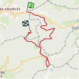
![](/images/other/stat-length.png)
![Randonnée Marche Bussang - Col de Bussang - Rouge Gazon - Séchenat - Photo](https://media.geolcdn.com/t/1900/400/ext.pjpeg?maxdim=2&url=https%3A%2F%2Fservices.sitytrail.com%2FGeolivesWS%2FDownloadMedia.ashx%3FTrailID%3D450013%26Media%3Dfix__20150715145430.jpg)
Col de Bussang - Rouge Gazon - Séchenat
VacheKiri67
Utilisateur
![Longueur](/images/other/stat-length.png)
![Altitude max](https://static1.geolcdn.com/siteimages/upload/files/1508320355ic_sort_altitude_max_24dp.png)
![Dénivelé positif](https://static1.geolcdn.com/siteimages/upload/files/1508320355ic_sort_den_pos_24dp.png)
![Km-Effort](/images/other/stat-length.png)
![Altitude min](https://static1.geolcdn.com/siteimages/upload/files/1508320355ic_sort_altitude_min_24dp.png)
![Dénivelé négatif](https://static1.geolcdn.com/siteimages/upload/files/1508320355ic_sort_den_neg_24dp.png)
![Boucle](https://static1.geolcdn.com/siteimages/upload/files/16400158638029165_repeat_loop_refresh_sync_direction_icon.png)
![Marche](https://static1.geolcdn.com/sitytour/trail-icons/101.png)
6h00
Difficulté : Difficile
![Scannez ce code QR pour ouvrir la randonnée dans l'application SityTrail](https://capi.geolives.com/qq0zvz2zws4bq2lad0pu/sitytour/trails/450013/qr.png?size=200)
Application GPS de randonnée GRATUITE
À propos
Randonnée Marche de 15 km à découvrir à Grand Est, Vosges, Bussang. Cette randonnée est proposée par VacheKiri67.
Description
Faite le 15/07/2015 avec notre fils de 10 ans. Enregistrement partiel. D'après : Guide Frank Vosges - N°31 Col de Bussang - Rouge Gazon - Séchenat. La durée indiquée pour le circuit est de 5h. Nous avons complété ce parcours avec la montée au sommet de la Tête des Perches.
Localisation
Commentaires
Randonnées à proximité
![Randonnée Raquettes à neige Bussang - Circuit de raquette de Bussang - Photo](https://media.geolcdn.com/t/375/260/ext.jpg?maxdim=2&url=https%3A%2F%2Fservices.sitytrail.com%2FGeolivesWS%2FDownloadMedia.ashx%3FTrailID%3D111638%26Media%3D7873_6.jpg)
![Raquettes à neige Raquettes à neige](https://static1.geolcdn.com/sitytour/trail-icons/504.png)
Raquettes à neige
![](/images/other/stat-length.png)
![](https://static1.geolcdn.com/siteimages/upload/files/16400158638029165_repeat_loop_refresh_sync_direction_icon.png)
![Randonnée Marche Storckensohn - lac des perches marchettes - Photo](https://media.geolcdn.com/t/375/260/ba8e93c4-c66a-48b1-88b8-cca79cc3effc.jpg&format=jpg&maxdim=2)
![Marche Marche](https://static1.geolcdn.com/sitytour/trail-icons/101.png)
Marche
![](/images/other/stat-length.png)
![](https://static1.geolcdn.com/siteimages/upload/files/16400158638029165_repeat_loop_refresh_sync_direction_icon.png)
![Randonnée Marche Fellering - Felsach _chapelle ST Nicolas_frenz - Photo](https://media.geolcdn.com/t/375/260/ext.jpg?maxdim=2&url=https%3A%2F%2Fstatic1.geolcdn.com%2Fsiteimages%2Fupload%2Ffiles%2F1553511878bg_sport_marche.png)
![Marche Marche](https://static1.geolcdn.com/sitytour/trail-icons/101.png)
Marche
![](/images/other/stat-length.png)
![](https://static1.geolcdn.com/siteimages/upload/files/16400158638029165_repeat_loop_refresh_sync_direction_icon.png)
![V.T.T. V.T.T.](https://static1.geolcdn.com/sitytour/trail-icons/202.png)
V.T.T.
![](/images/other/stat-length.png)
![](https://static1.geolcdn.com/siteimages/upload/files/16400158638029165_repeat_loop_refresh_sync_direction_icon.png)
![Randonnée Marche Storckensohn - 2022-07-16 Marche Auberge Gazon Vert Chapelle des Ves - Photo](https://media.geolcdn.com/t/375/260/7aac2105-88e6-44f1-a6d0-d41240d9f4c5.jpg&format=jpg&maxdim=2)
![Marche Marche](https://static1.geolcdn.com/sitytour/trail-icons/101.png)
Marche
![](/images/other/stat-length.png)
![](https://static1.geolcdn.com/siteimages/upload/files/16400158638029165_repeat_loop_refresh_sync_direction_icon.png)
![Randonnée Marche Ventron - 2022-02-19 Marche Ventron Tête des Champs - Photo](https://media.geolcdn.com/t/375/260/06aadd17-f4b2-4026-a19b-5cf0f11fcd92.jpg&format=jpg&maxdim=2)
![Marche Marche](https://static1.geolcdn.com/sitytour/trail-icons/101.png)
Marche
![](/images/other/stat-length.png)
![](https://static1.geolcdn.com/siteimages/upload/files/16400158638029165_repeat_loop_refresh_sync_direction_icon.png)
![Randonnée A pied Ventron - Circuit de la Croix de l’Hermite par Forgoutte - Photo](https://media.geolcdn.com/t/375/260/d9c2017f-89af-4e26-9799-43d15f74a50f.jpeg&format=jpg&maxdim=2)
![A pied A pied](https://static1.geolcdn.com/sitytour/trail-icons/100.png)
A pied
![](/images/other/stat-length.png)
![](https://static1.geolcdn.com/siteimages/upload/files/16400158638029165_repeat_loop_refresh_sync_direction_icon.png)
![Randonnée A pied Ventron - Circuit panoramique de la Futaie - Photo](https://media.geolcdn.com/t/375/260/eb0c45ef-a3eb-4f0d-8469-bf703ef6a7a4.jpeg&format=jpg&maxdim=2)
![A pied A pied](https://static1.geolcdn.com/sitytour/trail-icons/100.png)
A pied
![](/images/other/stat-length.png)
![](https://static1.geolcdn.com/siteimages/upload/files/16400158638029165_repeat_loop_refresh_sync_direction_icon.png)
![V.T.T. V.T.T.](https://static1.geolcdn.com/sitytour/trail-icons/202.png)
V.T.T.
![](/images/other/stat-length.png)
![](https://static1.geolcdn.com/siteimages/upload/files/16400158638029165_repeat_loop_refresh_sync_direction_icon.png)
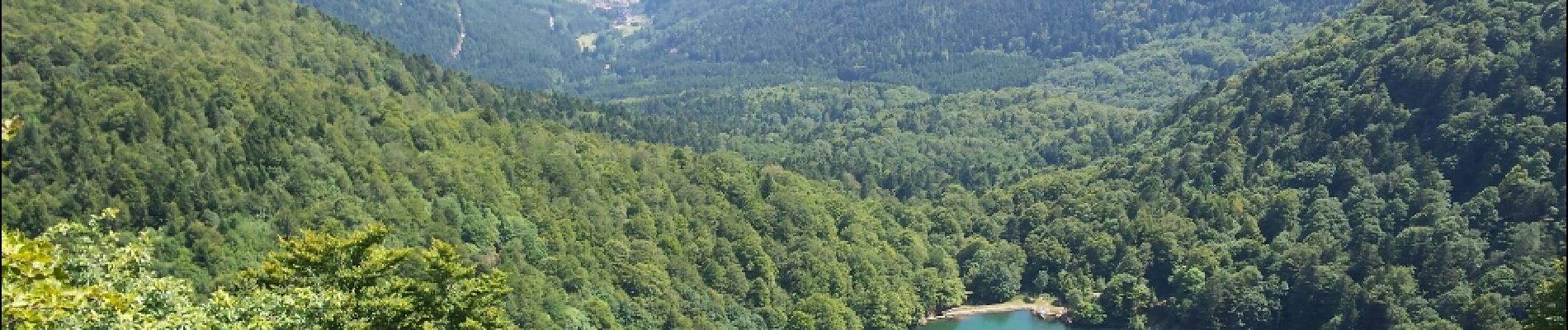
La montée au sommet de la Tête des Perches offre une vue magnifique sur le lac.