Randonnée Marche Bordes-Uchentein - Maison du Valier - Guzet - Photo

Maison du Valier - Guzet

 flayssac
flayssac

Utilisateur

© OpenStreetMap contributors
Longueur
Longueur
54 km
Altitude max
Altitude max
2593 m
Dénivelé positif
Dénivelé positif
4874 m
Km-Effort
Km-Effort  
116 km
Altitude min
Altitude min
934 m
Dénivelé négatif
Dénivelé négatif
4077 m
Boucle
Boucle
Non
Date de création :
2015-07-18 00:00:00.0
Dernière modification :
2015-07-18 00:00:00.0

(0 Avis)

Marche
Marche
23h12
Difficulté : Difficile

Scannez ce code QR pour ouvrir la randonnée dans l'application SityTrail

Application GPS de randonnée GRATUITE

Logo SityTrail SityTrail

IGN / Instituts géographiques

Télécharger SityTrail sur l'App Store Télécharger SityTrail sur Google Play

Logo SityTrail SityTrail World

Le monde est à vous

Télécharger SityTrail sur l'App Store Télécharger SityTrail sur Google Play Télécharger SityTrail sur Huawei AppGallery

À propos

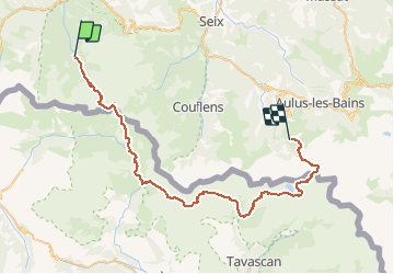
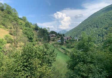
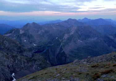
Randonnée Marche de 54 km à découvrir à Occitanie, Ariège, Bordes-Uchentein. Cette randonnée est proposée par flayssac.

Description

Trek de 5 jours reliant la maison du Valier à Guzet.

Profil altimétrique

Points d'intérêt

Point d'intérêt Bordes-Uchentein - Bivouac J1 - Photo
flayssac
BORDES-UCHENTEIN 
Point d'intérêt Alt Àneu - Bivouac J2 - Photo
flayssac
ALT ÀNEU 
Point d'intérêt Lladorre - Bivouac J3 - Photo
flayssac
LLADORRE 
Point d'intérêt Lladorre - Bivouac J3 - Photo
flayssac
LLADORRE 
Point d'intérêt Ustou - Chalet de Beauregard - Photo
flayssac

Localisation

Pays :
France
Région :
Occitanie
Département/Province :
Ariège
Commune :
Bordes-Uchentein
Localité :
Les Bordes-sur-Lez
Départ:(Dec)
Départ:(UTM)
339087 ; 4744068 (31T) N.

Randonnées à proximité

Randonnée Marche Bethmale - Bethmale - Photo
Marche
Gepeto_22

Marche

Moyen
(2)
Bethmale, Occitanie, Ariège, France
5,4 km | 8,8 km-effort
2h 20min
Oui
Randonnée Marche Bethmale -  Circuit des cinq étangs (2237m) - Photo
Marche
tigrou31

Marche

Difficile
(3)
Bethmale, Occitanie, Ariège, France
18,1 km | 33 km-effort
Inconnu
Oui
Randonnée Marche Bordes-Uchentein - Pic de la Pale de la Clauère - Photo
Marche
beautrix

Marche

Très difficile
(1)
Bordes-Uchentein, Occitanie, Ariège, France
7,7 km | 20 km-effort
4h 1min
Oui
Randonnée Marche Bonac-Irazein - tunnels du Biros ou sentier Decauville - Photo
Marche
chrisgps

Marche

Très difficile
Bonac-Irazein, Occitanie, Ariège, France
17,8 km | 29 km-effort
6h 35min
Oui
Randonnée Marche Bonac-Irazein - Sentier du port d’Orle - col du Tuc - Photo
Marche
altaya

Marche

Facile
Bonac-Irazein, Occitanie, Ariège, France
13,7 km | 27 km-effort
6h 20min
Oui
Randonnée Marche Bordes-Uchentein - 2022 TRANSPYRÉNÉENNE - refuge du Valier -refuge d’Esbints - Photo
Marche
LEGUE

Marche

Très difficile
Bordes-Uchentein, Occitanie, Ariège, France
18,5 km | 35 km-effort
5h 25min
Non
Randonnée A pied Bethmale - Grand circuit dans la Réserve Naturelle du Mont Valier - Photo
A pied
PRO

A pied

Facile
Bethmale, Occitanie, Ariège, France
9,5 km | 19,6 km-effort
4h 26min
Non
Randonnée A pied Bordes-Uchentein - Étangs Long et Rond - Photo
A pied
PRO

A pied

Difficile
Bordes-Uchentein, Occitanie, Ariège, France
15,8 km | 36 km-effort
8h 7min
Non
Randonnée Marche Bethmale - refuge Salvador - Photo
Marche
chrisgps

Marche

Très difficile
Bethmale, Occitanie, Ariège, France
16 km | 25 km-effort
5h 46min
Oui


Fermer
Mes abonnements