![](/images/other/stat-length.png)
![Randonnée Marche Grächen - YHH073 Grächen - Herbriggen - Photo](https://media.geolcdn.com/t/1900/400/ext.pjpeg?maxdim=2&url=https%3A%2F%2Fstatic1.geolcdn.com%2Fsiteimages%2Fupload%2Ffiles%2F1553511878bg_sport_marche.png)
YHH073 Grächen - Herbriggen
yveshumbert
Utilisateur
![Longueur](/images/other/stat-length.png)
Longueur
12,4 km
![Altitude max](https://static1.geolcdn.com/siteimages/upload/files/1508320355ic_sort_altitude_max_24dp.png)
Altitude max
1704 m
![Dénivelé positif](https://static1.geolcdn.com/siteimages/upload/files/1508320355ic_sort_den_pos_24dp.png)
Dénivelé positif
298 m
![Km-Effort](/images/other/stat-length.png)
Km-Effort
17,5 km
![Altitude min](https://static1.geolcdn.com/siteimages/upload/files/1508320355ic_sort_altitude_min_24dp.png)
Altitude min
1223 m
![Dénivelé négatif](https://static1.geolcdn.com/siteimages/upload/files/1508320355ic_sort_den_neg_24dp.png)
Dénivelé négatif
652 m
![Boucle](https://static1.geolcdn.com/siteimages/upload/files/16400158638029165_repeat_loop_refresh_sync_direction_icon.png)
Boucle
Non
Date de création :
2014-12-10 00:00:00.0
Dernière modification :
2014-12-10 00:00:00.0
![Marche](https://static1.geolcdn.com/sitytour/trail-icons/101.png)
4h30
Difficulté : Inconnu
![Scannez ce code QR pour ouvrir la randonnée dans l'application SityTrail](https://capi.geolives.com/qq0zvz2zws4bq2lad0pu/sitytour/trails/44537/qr.png?size=200)
Application GPS de randonnée GRATUITE
À propos
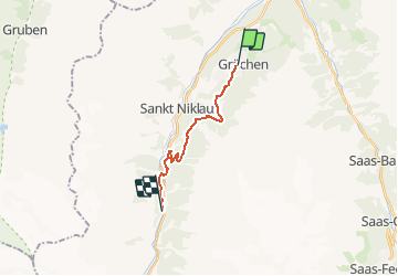
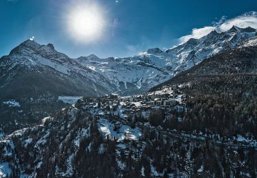
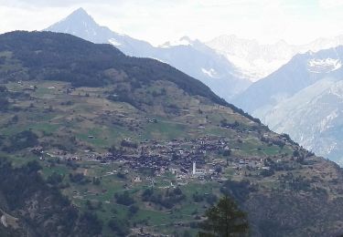
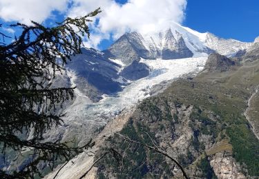
Randonnée Marche de 12,4 km à découvrir à Valais, Viège, Grächen. Cette randonnée est proposée par yveshumbert.
Description
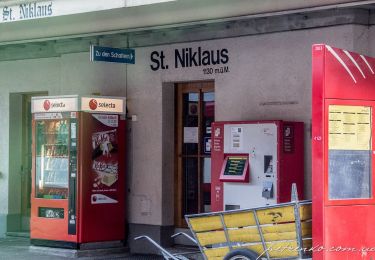
Pendant cette randonnée on suit un chemin à flanc le long de la vallée de Zermatt. On descend dans la vallée au niveau de Herbriggen. Le retour se fait en car postale ou en train (vérifier les horaires avant de partir)
Localisation
Pays :
Suisse
Région :
Valais
Département/Province :
Viège
Commune :
Grächen
Localité :
Unknown
Départ:(Dec)
Départ:(UTM)
410394 ; 5116385 (32T) N.
Commentaires
Randonnées à proximité
![Randonnée A pied Grächen - Grächen-St. Niklaus - Photo](https://media.geolcdn.com/t/375/260/27fabdfb-4bab-4a73-9b5c-c2b30f7601b1.jpeg&format=jpg&maxdim=2)
![A pied A pied](https://static1.geolcdn.com/sitytour/trail-icons/100.png)
Grächen-St. Niklaus
A pied
Facile
Grächen,
Valais,
Viège,
Suisse
![](/images/other/stat-length.png)
4,3 km | 6,2 km-effort
1h 23min
![](https://static1.geolcdn.com/siteimages/upload/files/16400158638029165_repeat_loop_refresh_sync_direction_icon.png)
Non
![Randonnée A pied Grächen - Hannigalp-Saas-Fee - Photo](https://media.geolcdn.com/t/375/260/13565212-d8f8-4a73-b70e-442e2ce34d21.jpeg&format=jpg&maxdim=2)
![A pied A pied](https://static1.geolcdn.com/sitytour/trail-icons/100.png)
![Randonnée A pied St. Niklaus - St. Niklaus - Jungu - Photo](https://media.geolcdn.com/t/375/260/e9e7da26-cfc6-42ac-9275-6ff2bda77838.jpeg&format=jpg&maxdim=2)
![A pied A pied](https://static1.geolcdn.com/sitytour/trail-icons/100.png)
St. Niklaus - Jungu
A pied
Facile
St. Niklaus,
Valais,
Viège,
Suisse
![](/images/other/stat-length.png)
4,1 km | 12,3 km-effort
2h 48min
![](https://static1.geolcdn.com/siteimages/upload/files/16400158638029165_repeat_loop_refresh_sync_direction_icon.png)
Non
![Randonnée A pied St. Niklaus - Untere Läger-Augstbordpass - Photo](https://media.geolcdn.com/t/375/260/e9e7da26-cfc6-42ac-9275-6ff2bda77838.jpeg&format=jpg&maxdim=2)
![A pied A pied](https://static1.geolcdn.com/sitytour/trail-icons/100.png)
Untere Läger-Augstbordpass
A pied
Facile
St. Niklaus,
Valais,
Viège,
Suisse
![](/images/other/stat-length.png)
5,5 km | 12,5 km-effort
2h 50min
![](https://static1.geolcdn.com/siteimages/upload/files/16400158638029165_repeat_loop_refresh_sync_direction_icon.png)
Non
![Randonnée Marche Grächen - Grächen et ses bisses 07.2018 - Photo](https://media.geolcdn.com/t/375/260/ext.jpg?maxdim=2&url=https%3A%2F%2Fservices.sitytrail.com%2FGeolivesWS%2FDownloadMedia.ashx%3FTrailID%3D1004149%26Media%3D8093b6a4-1bb2-49b2-80d3-6c3b30602d2f.jpg)
![Marche Marche](https://static1.geolcdn.com/sitytour/trail-icons/101.png)
Grächen et ses bisses 07.2018
Marche
Moyen
Grächen,
Valais,
Viège,
Suisse
![](/images/other/stat-length.png)
14,1 km | 19,8 km-effort
4h 10min
![](https://static1.geolcdn.com/siteimages/upload/files/16400158638029165_repeat_loop_refresh_sync_direction_icon.png)
Oui
![Randonnée Marche St. Niklaus - La Haute Route : J10 - Photo](https://media.geolcdn.com/t/375/260/80e64528-d2bf-49c5-869c-d28ac7478b9b.jpg&format=jpg&maxdim=2)
![Marche Marche](https://static1.geolcdn.com/sitytour/trail-icons/101.png)
La Haute Route : J10
Marche
Difficile
St. Niklaus,
Valais,
Viège,
Suisse
![](/images/other/stat-length.png)
12,2 km | 26 km-effort
4h 3min
![](https://static1.geolcdn.com/siteimages/upload/files/16400158638029165_repeat_loop_refresh_sync_direction_icon.png)
Non
![Randonnée Autre activité Staldenried - sf10_e11c - Photo](https://media.geolcdn.com/t/375/260/ext.jpg?maxdim=2&url=https%3A%2F%2Fstatic1.geolcdn.com%2Fsiteimages%2Fupload%2Ffiles%2F1545311037marcheuse_200dpi.jpg)
![Autre activité Autre activité](https://static1.geolcdn.com/sitytour/trail-icons/900.png)
sf10_e11c
Autre activité
Très facile
Staldenried,
Valais,
Viège,
Suisse
![](/images/other/stat-length.png)
19,3 km | 35 km-effort
8h 30min
![](https://static1.geolcdn.com/siteimages/upload/files/16400158638029165_repeat_loop_refresh_sync_direction_icon.png)
Non
![Randonnée Autre activité Staldenried - y10_gspon_saas - Photo](https://media.geolcdn.com/t/375/260/ext.jpg?maxdim=2&url=https%3A%2F%2Fstatic1.geolcdn.com%2Fsiteimages%2Fupload%2Ffiles%2F1545311037marcheuse_200dpi.jpg)
![Autre activité Autre activité](https://static1.geolcdn.com/sitytour/trail-icons/900.png)
y10_gspon_saas
Autre activité
Très facile
Staldenried,
Valais,
Viège,
Suisse
![](/images/other/stat-length.png)
19,3 km | 33 km-effort
7h 50min
![](https://static1.geolcdn.com/siteimages/upload/files/16400158638029165_repeat_loop_refresh_sync_direction_icon.png)
Non
![Randonnée V.T.T. Staldenried - Gspon - Photo](https://media.geolcdn.com/t/375/260/ext.jpg?maxdim=2&url=https%3A%2F%2Fstatic1.geolcdn.com%2Fsiteimages%2Fupload%2Ffiles%2F1524743154velo.jpg)
![V.T.T. V.T.T.](https://static1.geolcdn.com/sitytour/trail-icons/202.png)