


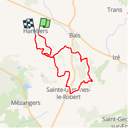

22 km | 27 km-effort


Utilisateur


Application GPS de randonnée GRATUITE
 SityTrail
IGN / Instituts géographiques
SityTrail World
Le monde est à vous
Randonnée Cheval de 27 km à découvrir à Pays de la Loire, Mayenne, Hambers. Cette randonnée est proposée par mimi53.
Randonnée Annuelle des Chevaux du Montaigu le 12 juillet 2015 au départ d'hambers pour une très belle rando sur les buttes du Rochard
A pied
A pied
Marche

Marche
Marche

Cheval
Cheval
Marche
Marche