![](/images/other/stat-length.png)
![Randonnée Marche Peyriac-de-Mer - L'étang du Doul - Photo](https://media.geolcdn.com/t/1900/400/ext.pjpeg?maxdim=2&url=https%3A%2F%2Fstatic1.geolcdn.com%2Fsiteimages%2Fupload%2Ffiles%2F1553511878bg_sport_marche.png)
L'étang du Doul
7217Lionel
Utilisateur
![Longueur](/images/other/stat-length.png)
Longueur
6,8 km
![Altitude max](https://static1.geolcdn.com/siteimages/upload/files/1508320355ic_sort_altitude_max_24dp.png)
Altitude max
50 m
![Dénivelé positif](https://static1.geolcdn.com/siteimages/upload/files/1508320355ic_sort_den_pos_24dp.png)
Dénivelé positif
95 m
![Km-Effort](/images/other/stat-length.png)
Km-Effort
8 km
![Altitude min](https://static1.geolcdn.com/siteimages/upload/files/1508320355ic_sort_altitude_min_24dp.png)
Altitude min
0 m
![Dénivelé négatif](https://static1.geolcdn.com/siteimages/upload/files/1508320355ic_sort_den_neg_24dp.png)
Dénivelé négatif
96 m
![Boucle](https://static1.geolcdn.com/siteimages/upload/files/16400158638029165_repeat_loop_refresh_sync_direction_icon.png)
Boucle
Oui
Date de création :
2015-07-02 00:00:00.0
Dernière modification :
2015-07-02 00:00:00.0
![Marche](https://static1.geolcdn.com/sitytour/trail-icons/101.png)
1h47
Difficulté : Facile
![Scannez ce code QR pour ouvrir la randonnée dans l'application SityTrail](https://capi.geolives.com/qq0zvz2zws4bq2lad0pu/sitytour/trails/440468/qr.png?size=200)
Application GPS de randonnée GRATUITE
À propos
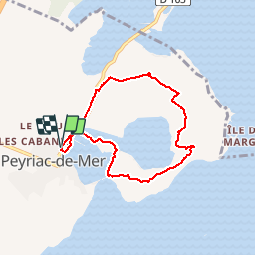
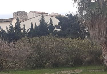
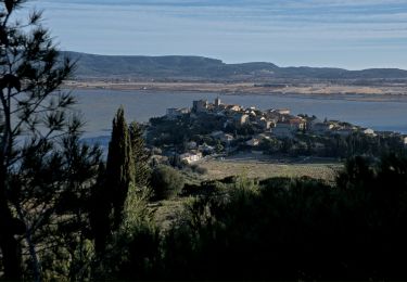
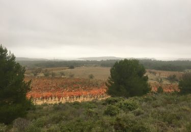
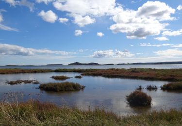
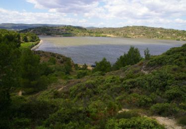
Randonnée Marche de 6,8 km à découvrir à Occitanie, Aude, Peyriac-de-Mer. Cette randonnée est proposée par 7217Lionel.
Description
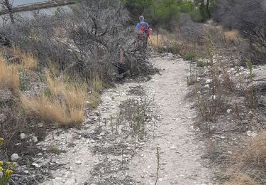
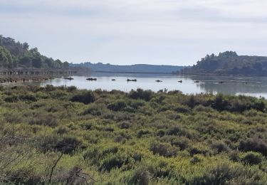
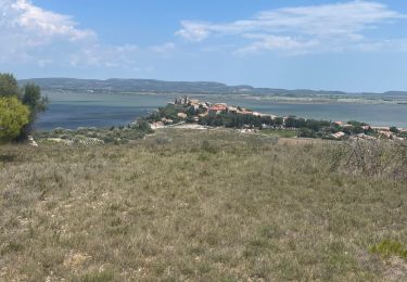
Parcourez sur des passerelles en bois l'ancienne saline de Peyriac-de-Mer, pour emprunter ensuite le sentier entre les étangs du Doul et Bages, au cœur d'une riche flore méditerranéenne.
Localisation
Pays :
France
Région :
Occitanie
Département/Province :
Aude
Commune :
Peyriac-de-Mer
Localité :
Unknown
Départ:(Dec)
Départ:(UTM)
496699 ; 4770764 (31T) N.
Commentaires
Randonnées à proximité
![Randonnée Marche Bages - BAGES - SOURCE DE BAJOLE - POINT DE VUE A L OLIVET 9.8KMS 2h41 - Photo](https://media.geolcdn.com/t/375/260/ext.jpg?maxdim=2&url=https%3A%2F%2Fstatic1.geolcdn.com%2Fsiteimages%2Fupload%2Ffiles%2F1553511878bg_sport_marche.png)
![Marche Marche](https://static1.geolcdn.com/sitytour/trail-icons/101.png)
BAGES - SOURCE DE BAJOLE - POINT DE VUE A L OLIVET 9.8KMS 2h41
Marche
Moyen
(1)
Bages,
Occitanie,
Aude,
France
![](/images/other/stat-length.png)
9,8 km | 12,5 km-effort
2h 41min
![](https://static1.geolcdn.com/siteimages/upload/files/16400158638029165_repeat_loop_refresh_sync_direction_icon.png)
Oui
![Randonnée Marche Peyriac-de-Mer - peyriac bages peyriac - Photo](https://media.geolcdn.com/t/375/260/4e7857ab-3da4-4579-be68-eab06d888ebf.jpg&format=jpg&maxdim=2)
![Marche Marche](https://static1.geolcdn.com/sitytour/trail-icons/101.png)
peyriac bages peyriac
Marche
Difficile
Peyriac-de-Mer,
Occitanie,
Aude,
France
![](/images/other/stat-length.png)
14,3 km | 17,1 km-effort
5h 19min
![](https://static1.geolcdn.com/siteimages/upload/files/16400158638029165_repeat_loop_refresh_sync_direction_icon.png)
Oui
![Randonnée Marche Peyriac-de-Mer - PEYRIAC DE MER en boucle - Photo](https://media.geolcdn.com/t/375/260/ebbf8f3d-cec9-4ce2-95b9-a7ad43ef2a83.jpg&format=jpg&maxdim=2)
![Marche Marche](https://static1.geolcdn.com/sitytour/trail-icons/101.png)
PEYRIAC DE MER en boucle
Marche
Très facile
Peyriac-de-Mer,
Occitanie,
Aude,
France
![](/images/other/stat-length.png)
9,5 km | 11,2 km-effort
2h 50min
![](https://static1.geolcdn.com/siteimages/upload/files/16400158638029165_repeat_loop_refresh_sync_direction_icon.png)
Oui
![Randonnée Marche Bages - Nages d’Aude - Photo](https://media.geolcdn.com/t/375/260/9a574c14-2c6d-48d7-8d17-a80e8738a083.jpg&format=jpg&maxdim=2)
![Marche Marche](https://static1.geolcdn.com/sitytour/trail-icons/101.png)
![Randonnée Marche Peyriac-de-Mer - peyriac de mer . étang de doul . roc de vidal . pêche rouge . croix St Paul. peyriac - Photo](https://media.geolcdn.com/t/375/260/3df76c5b-37e4-463d-aabf-a4155f686d68.jpg&format=jpg&maxdim=2)
![Marche Marche](https://static1.geolcdn.com/sitytour/trail-icons/101.png)
peyriac de mer . étang de doul . roc de vidal . pêche rouge . croix St Paul. ...
Marche
Facile
Peyriac-de-Mer,
Occitanie,
Aude,
France
![](/images/other/stat-length.png)
13,2 km | 15,3 km-effort
4h 37min
![](https://static1.geolcdn.com/siteimages/upload/files/16400158638029165_repeat_loop_refresh_sync_direction_icon.png)
Oui
![Randonnée Marche Bages - Boucle de Bages à Peyrac-de-Mer - Photo](https://media.geolcdn.com/t/375/260/ab0d61f3-4a50-4876-a7cc-26d36bfb2d3e.jpg&format=jpg&maxdim=2)
![Marche Marche](https://static1.geolcdn.com/sitytour/trail-icons/101.png)
Boucle de Bages à Peyrac-de-Mer
Marche
Très facile
Bages,
Occitanie,
Aude,
France
![](/images/other/stat-length.png)
17,7 km | 21 km-effort
6h 39min
![](https://static1.geolcdn.com/siteimages/upload/files/16400158638029165_repeat_loop_refresh_sync_direction_icon.png)
Oui
![Randonnée Marche Bages - Prat-de-Cest - Abbaye de Fontfroide - Photo](https://media.geolcdn.com/t/375/260/fd3516f0-d21c-487d-b7cc-d412f56ad9ce.jpg&format=jpg&maxdim=2)
![Marche Marche](https://static1.geolcdn.com/sitytour/trail-icons/101.png)
Prat-de-Cest - Abbaye de Fontfroide
Marche
Moyen
Bages,
Occitanie,
Aude,
France
![](/images/other/stat-length.png)
14,3 km | 19,2 km-effort
4h 10min
![](https://static1.geolcdn.com/siteimages/upload/files/16400158638029165_repeat_loop_refresh_sync_direction_icon.png)
Oui
![Marche Marche](https://static1.geolcdn.com/sitytour/trail-icons/101.png)
De Bages à Peyriac-de-Mer - Tour de la lagune
Marche
Très facile
Bages,
Occitanie,
Aude,
France
![](/images/other/stat-length.png)
17,8 km | 21 km-effort
5h 20min
![](https://static1.geolcdn.com/siteimages/upload/files/16400158638029165_repeat_loop_refresh_sync_direction_icon.png)
Oui
![Randonnée Marche Peyriac-de-Mer - Le tour de l'étang du Doul - Photo](https://media.geolcdn.com/t/375/260/ext.jpg?maxdim=2&url=https%3A%2F%2Fservices.sitytrail.com%2FGeolivesWS%2FDownloadMedia.ashx%3FTrailID%3D108811%26Media%3D2200_5.jpg)
![Marche Marche](https://static1.geolcdn.com/sitytour/trail-icons/101.png)
Le tour de l'étang du Doul
Marche
Moyen
Peyriac-de-Mer,
Occitanie,
Aude,
France
![](/images/other/stat-length.png)
5,2 km | 6,9 km-effort
2h 0min
![](https://static1.geolcdn.com/siteimages/upload/files/16400158638029165_repeat_loop_refresh_sync_direction_icon.png)
Oui