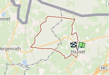
![](/images/other/stat-length.png)
![Randonnée Marche Raeren - 20250210 - Hauset 7 Km - Photo](https://media.geolcdn.com/t/1900/400/6b7d0b36-9689-4cbe-b735-6a5c4dbf0107.jpeg&format=pjpeg&maxdim=2)
20250210 - Hauset 7 Km
pierreh01
Utilisateur GUIDE
![Longueur](/images/other/stat-length.png)
![Altitude max](https://static1.geolcdn.com/siteimages/upload/files/1508320355ic_sort_altitude_max_24dp.png)
![Dénivelé positif](https://static1.geolcdn.com/siteimages/upload/files/1508320355ic_sort_den_pos_24dp.png)
![Km-Effort](/images/other/stat-length.png)
![Altitude min](https://static1.geolcdn.com/siteimages/upload/files/1508320355ic_sort_altitude_min_24dp.png)
![Dénivelé négatif](https://static1.geolcdn.com/siteimages/upload/files/1508320355ic_sort_den_neg_24dp.png)
![Boucle](https://static1.geolcdn.com/siteimages/upload/files/16400158638029165_repeat_loop_refresh_sync_direction_icon.png)
![Marche](https://static1.geolcdn.com/sitytour/trail-icons/101.png)
1h52
Difficulté : Moyen
![Scannez ce code QR pour ouvrir la randonnée dans l'application SityTrail](https://capi.geolives.com/qq0zvz2zws4bq2lad0pu/sitytour/trails/4349516/qr.png?size=200)
Application GPS de randonnée GRATUITE
À propos
Randonnée Marche de 7 km à découvrir à Wallonie, Liège, Raeren. Cette randonnée est proposée par pierreh01.
Description
Lundi 10 février 2025 : Balade hebdomadaire des "BIOS".
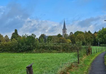
C'est sous une météo assez bouchée, avec même quelques petites gouttes de pluie, que quelques 23 "BIOS" (11 femmes & 12 hommes) se sont lancés à la suite de nos guides du jour, Christine & Dany.
Nous avons arpentés pas mal de sentiers forestiers dans une région bien peu connue de nos marcheurs.
Belle balade en découverte.
Distance mesurée de 7 Km avec Sity Trail.
Localisation
Commentaires
Randonnées à proximité
![Randonnée Marche La Calamine - Le pays calaminaire - Photo](https://media.geolcdn.com/t/375/260/30655fe2-e81a-47ed-96f4-20092bed94b7.jpg&format=jpg&maxdim=2)
![Marche Marche](https://static1.geolcdn.com/sitytour/trail-icons/101.png)
Marche
![](/images/other/stat-length.png)
![](https://static1.geolcdn.com/siteimages/upload/files/16400158638029165_repeat_loop_refresh_sync_direction_icon.png)
![Randonnée Marche Raeren - Aix-la-Chapelle_392 - Photo](https://media.geolcdn.com/t/375/260/3a31813f-998d-4148-baa8-502439fc02b8.jpg&format=jpg&maxdim=2)
![Marche Marche](https://static1.geolcdn.com/sitytour/trail-icons/101.png)
Marche
![](/images/other/stat-length.png)
![](https://static1.geolcdn.com/siteimages/upload/files/16400158638029165_repeat_loop_refresh_sync_direction_icon.png)
![Randonnée Marche La Calamine - La Calamine - Photo](https://media.geolcdn.com/t/375/260/606e5792-434a-491a-b5eb-2bfc2ef6f1ed.jpg&format=jpg&maxdim=2)
![Marche Marche](https://static1.geolcdn.com/sitytour/trail-icons/101.png)
Marche
![](/images/other/stat-length.png)
![](https://static1.geolcdn.com/siteimages/upload/files/16400158638029165_repeat_loop_refresh_sync_direction_icon.png)
![Randonnée Marche Aix-la-Chapelle - Aix-la-Chapelle - Photo](https://media.geolcdn.com/t/375/260/19678e47-68ef-4997-bad3-67eb75fafd82.jpg&format=jpg&maxdim=2)
![Marche Marche](https://static1.geolcdn.com/sitytour/trail-icons/101.png)
Marche
![](/images/other/stat-length.png)
![](https://static1.geolcdn.com/siteimages/upload/files/16400158638029165_repeat_loop_refresh_sync_direction_icon.png)
![Randonnée Marche Aix-la-Chapelle - Aix-la-Chapelle - Photo](https://media.geolcdn.com/t/375/260/efbe95f3-eeed-42aa-9acc-74aad4d18b78.jpg&format=jpg&maxdim=2)
![Marche Marche](https://static1.geolcdn.com/sitytour/trail-icons/101.png)
Marche
![](/images/other/stat-length.png)
![](https://static1.geolcdn.com/siteimages/upload/files/16400158638029165_repeat_loop_refresh_sync_direction_icon.png)
![Randonnée Marche La Calamine - Kelmis - Photo](https://media.geolcdn.com/t/375/260/9eea9d75-ea39-4660-b255-7d2a2255555e.jpg&format=jpg&maxdim=2)
![Marche Marche](https://static1.geolcdn.com/sitytour/trail-icons/101.png)
Marche
![](/images/other/stat-length.png)
![](https://static1.geolcdn.com/siteimages/upload/files/16400158638029165_repeat_loop_refresh_sync_direction_icon.png)
![Randonnée Marche Raeren - Lichtenbusch - Photo](https://media.geolcdn.com/t/375/260/83311396-e126-40d9-b822-9da5f0d28323.jpg&format=jpg&maxdim=2)
![Marche Marche](https://static1.geolcdn.com/sitytour/trail-icons/101.png)
Marche
![](/images/other/stat-length.png)
![](https://static1.geolcdn.com/siteimages/upload/files/16400158638029165_repeat_loop_refresh_sync_direction_icon.png)
![Randonnée Marche Raeren - Raeren - Photo](https://media.geolcdn.com/t/375/260/423c8447-b257-4538-8bf5-b82f7fde1439.jpg&format=jpg&maxdim=2)
![Marche Marche](https://static1.geolcdn.com/sitytour/trail-icons/101.png)
![Randonnée Marche Raeren - Hauset - Photo](https://media.geolcdn.com/t/375/260/4dbde2fb-33e3-4e75-84b3-1404a45e04cc.jpg&format=jpg&maxdim=2)
![Marche Marche](https://static1.geolcdn.com/sitytour/trail-icons/101.png)