![](/images/other/stat-length.png)
Marche Adeps à Rance
Desrumaux
Utilisateur GUIDE
![Longueur](/images/other/stat-length.png)
Longueur
11,7 km
![Altitude max](https://static1.geolcdn.com/siteimages/upload/files/1508320355ic_sort_altitude_max_24dp.png)
Altitude max
278 m
![Dénivelé positif](https://static1.geolcdn.com/siteimages/upload/files/1508320355ic_sort_den_pos_24dp.png)
Dénivelé positif
140 m
![Km-Effort](/images/other/stat-length.png)
Km-Effort
13,5 km
![Altitude min](https://static1.geolcdn.com/siteimages/upload/files/1508320355ic_sort_altitude_min_24dp.png)
Altitude min
206 m
![Dénivelé négatif](https://static1.geolcdn.com/siteimages/upload/files/1508320355ic_sort_den_neg_24dp.png)
Dénivelé négatif
140 m
![Boucle](https://static1.geolcdn.com/siteimages/upload/files/16400158638029165_repeat_loop_refresh_sync_direction_icon.png)
Boucle
Oui
Date de création :
2015-06-17 00:00:00.0
Dernière modification :
2015-06-17 00:00:00.0
![Marche](https://static1.geolcdn.com/sitytour/trail-icons/101.png)
2h59
Difficulté : Facile
![Scannez ce code QR pour ouvrir la randonnée dans l'application SityTrail](https://capi.geolives.com/qq0zvz2zws4bq2lad0pu/sitytour/trails/434714/qr.png?size=200)
Application GPS de randonnée GRATUITE
À propos
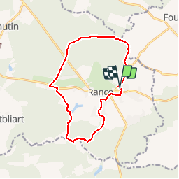
Randonnée Marche de 11,7 km à découvrir à Wallonie, Hainaut, Sivry-Rance. Cette randonnée est proposée par Desrumaux.
Description
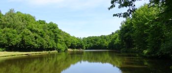
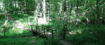
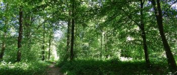
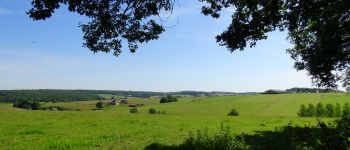
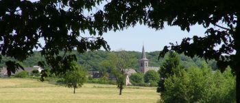
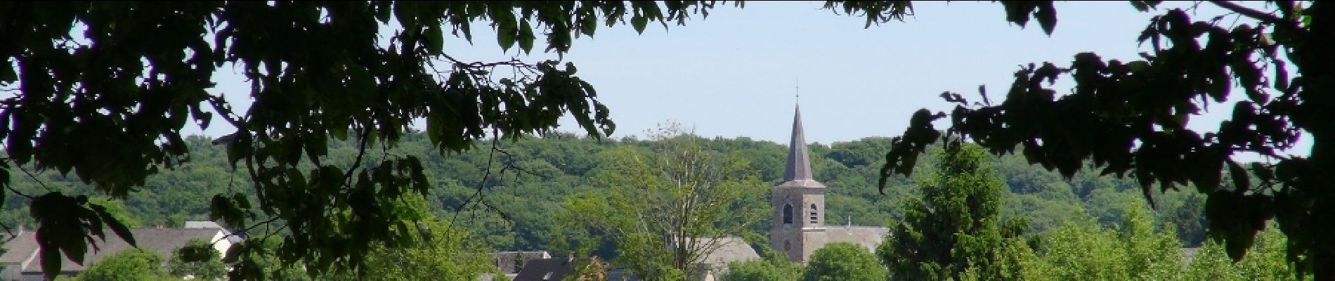
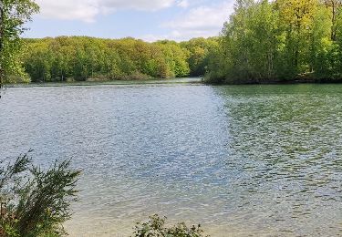
Très belle marche adeps dans la Botte du Hainaut au départ du joli village de Rance qui vous emmène dans la forêt domaniale et ses campagnes verdoyante.Départ : Rue Pauline Hubert
Localisation
Pays :
Belgique
Région :
Wallonie
Département/Province :
Hainaut
Commune :
Sivry-Rance
Localité :
Rance
Départ:(Dec)
Départ:(UTM)
591628 ; 5555486 (31U) N.
Commentaires
Randonnées à proximité
![Randonnée V.T.C. Sivry-Rance - Sivry Gare - Robechies - Rance - Photo](https://media.geolcdn.com/t/375/260/73d602ef-978e-4b6d-980e-4af8ec05b02c.jpg&format=jpg&maxdim=2)
![V.T.C. V.T.C.](https://static1.geolcdn.com/sitytour/trail-icons/203.png)
Sivry Gare - Robechies - Rance
V.T.C.
Très facile
(2)
Sivry-Rance,
Wallonie,
Hainaut,
Belgique
![](/images/other/stat-length.png)
41 km | 48 km-effort
2h 31min
![](https://static1.geolcdn.com/siteimages/upload/files/16400158638029165_repeat_loop_refresh_sync_direction_icon.png)
Oui
![Randonnée V.T.T. Froidchapelle - Froidchapelle (7) - Promenade VTT - Photo](https://media.geolcdn.com/t/375/260/ext.jpg?maxdim=2&url=https%3A%2F%2Fservices.sitytrail.com%2FGeolivesWS%2FDownloadMedia.ashx%3FTrailID%3D332241%26Media%3D0e28cef3-8d87-404e-aa4c-8e4248f5e1b1.JPG)
![V.T.T. V.T.T.](https://static1.geolcdn.com/sitytour/trail-icons/202.png)
Froidchapelle (7) - Promenade VTT
V.T.T.
Moyen
(4)
Froidchapelle,
Wallonie,
Hainaut,
Belgique
![](/images/other/stat-length.png)
32 km | 37 km-effort
2h 26min
![](https://static1.geolcdn.com/siteimages/upload/files/16400158638029165_repeat_loop_refresh_sync_direction_icon.png)
Oui
![Randonnée Marche Sivry-Rance - Sivry-Rance (06) - Sivry - Promenade du Grand Thumas - Photo](https://media.geolcdn.com/t/375/260/ext.jpg?maxdim=2&url=https%3A%2F%2Fservices.sitytrail.com%2FGeolivesWS%2FDownloadMedia.ashx%3FTrailID%3D311164%26Media%3D8cc43fbe-f875-4530-a462-14a28c742760.JPG)
![Marche Marche](https://static1.geolcdn.com/sitytour/trail-icons/101.png)
Sivry-Rance (06) - Sivry - Promenade du Grand Thumas
Marche
Très facile
(5)
Sivry-Rance,
Wallonie,
Hainaut,
Belgique
![](/images/other/stat-length.png)
5,5 km | 6,5 km-effort
1h 30min
![](https://static1.geolcdn.com/siteimages/upload/files/16400158638029165_repeat_loop_refresh_sync_direction_icon.png)
Oui
![Randonnée Marche Sivry-Rance - RB-Ha-10 - Rance - Photo](https://media.geolcdn.com/t/375/260/ext.jpg?maxdim=2&url=https%3A%2F%2Fservices.sitytrail.com%2FGeolivesWS%2FDownloadMedia.ashx%3FTrailID%3D219204%26Media%3De74974e9-21e7-4886-b770-97222bcdf8f4.jpg)
![Marche Marche](https://static1.geolcdn.com/sitytour/trail-icons/101.png)
RB-Ha-10 - Rance
Marche
Très difficile
(1)
Sivry-Rance,
Wallonie,
Hainaut,
Belgique
![](/images/other/stat-length.png)
21 km | 25 km-effort
5h 47min
![](https://static1.geolcdn.com/siteimages/upload/files/16400158638029165_repeat_loop_refresh_sync_direction_icon.png)
Oui
![Randonnée Marche Sivry-Rance - Sivry-Rance (13) - Promenade de la Vallée de l'Eau d'Eppe - Photo](https://media.geolcdn.com/t/375/260/ext.jpg?maxdim=2&url=https%3A%2F%2Fservices.sitytrail.com%2FGeolivesWS%2FDownloadMedia.ashx%3FTrailID%3D311163%26Media%3Db7af1830-b06f-43cc-9ab9-a464f12aaa86.JPG)
![Marche Marche](https://static1.geolcdn.com/sitytour/trail-icons/101.png)
Sivry-Rance (13) - Promenade de la Vallée de l'Eau d'Eppe
Marche
Très facile
(2)
Sivry-Rance,
Wallonie,
Hainaut,
Belgique
![](/images/other/stat-length.png)
6,6 km | 8,4 km-effort
2h 0min
![](https://static1.geolcdn.com/siteimages/upload/files/16400158638029165_repeat_loop_refresh_sync_direction_icon.png)
Oui
![Randonnée Marche Sivry-Rance - De Sautin vers Montbliart par la vallee de l'Eau d'Eppe - Photo](https://media.geolcdn.com/t/375/260/ext.jpg?maxdim=2&url=https%3A%2F%2Fstatic1.geolcdn.com%2Fsiteimages%2Fupload%2Ffiles%2F1553511878bg_sport_marche.png)
![Marche Marche](https://static1.geolcdn.com/sitytour/trail-icons/101.png)
De Sautin vers Montbliart par la vallee de l'Eau d'Eppe
Marche
Moyen
(1)
Sivry-Rance,
Wallonie,
Hainaut,
Belgique
![](/images/other/stat-length.png)
17,3 km | 21 km-effort
4h 20min
![](https://static1.geolcdn.com/siteimages/upload/files/16400158638029165_repeat_loop_refresh_sync_direction_icon.png)
Oui
![Randonnée Marche Froidchapelle - La balade du bois du Grand Oupia aux lacs de l'eau d'heure - Photo](https://media.geolcdn.com/t/375/260/73ecda4c-85a4-4092-8a72-382e3ad583a2.jpg&format=jpg&maxdim=2)
![Marche Marche](https://static1.geolcdn.com/sitytour/trail-icons/101.png)
La balade du bois du Grand Oupia aux lacs de l'eau d'heure
Marche
Moyen
(4)
Froidchapelle,
Wallonie,
Hainaut,
Belgique
![](/images/other/stat-length.png)
8,7 km | 9,9 km-effort
2h 15min
![](https://static1.geolcdn.com/siteimages/upload/files/16400158638029165_repeat_loop_refresh_sync_direction_icon.png)
Oui
![Randonnée A pied Sivry-Rance - Promenade du Ry d'Hernoy - Photo](https://media.geolcdn.com/t/375/260/3576f0ab-5152-4ef1-90e0-3b37b935b6bd.jpeg&format=jpg&maxdim=2)
![A pied A pied](https://static1.geolcdn.com/sitytour/trail-icons/100.png)
Promenade du Ry d'Hernoy
A pied
Facile
Sivry-Rance,
Wallonie,
Hainaut,
Belgique
![](/images/other/stat-length.png)
9,8 km | 11,8 km-effort
2h 41min
![](https://static1.geolcdn.com/siteimages/upload/files/16400158638029165_repeat_loop_refresh_sync_direction_icon.png)
Oui
![Randonnée A pied Sivry-Rance - Promenade circulaire de l'Ermitage - Photo](https://media.geolcdn.com/t/375/260/ext.jpg?maxdim=2&url=https%3A%2F%2Fpivotmedia.tourismewallonie.be%2FOTH-A0-004E-1IGH%2FOTH-A0-004E-1IGH.jpg)
![A pied A pied](https://static1.geolcdn.com/sitytour/trail-icons/100.png)
Promenade circulaire de l'Ermitage
A pied
Facile
Sivry-Rance,
Wallonie,
Hainaut,
Belgique
![](/images/other/stat-length.png)
4,7 km | 5,5 km-effort
1h 15min
![](https://static1.geolcdn.com/siteimages/upload/files/16400158638029165_repeat_loop_refresh_sync_direction_icon.png)
Oui