![](/images/other/stat-length.png)
![Randonnée A pied Strašice - Naučná stezka Okolím Padrťských rybníků - Photo](https://media.geolcdn.com/t/1900/400/e147a7f2-eddb-4a26-9a0c-ab5091189530.jpeg&format=pjpeg&maxdim=2)
Naučná stezka Okolím Padrťských rybníků
SityTrail - itinéraires balisés pédestres
Tous les sentiers balisés d’Europe GUIDE+
![Longueur](/images/other/stat-length.png)
Longueur
13,3 km
![Altitude max](https://static1.geolcdn.com/siteimages/upload/files/1508320355ic_sort_altitude_max_24dp.png)
Altitude max
715 m
![Dénivelé positif](https://static1.geolcdn.com/siteimages/upload/files/1508320355ic_sort_den_pos_24dp.png)
Dénivelé positif
270 m
![Km-Effort](/images/other/stat-length.png)
Km-Effort
16,9 km
![Altitude min](https://static1.geolcdn.com/siteimages/upload/files/1508320355ic_sort_altitude_min_24dp.png)
Altitude min
620 m
![Dénivelé négatif](https://static1.geolcdn.com/siteimages/upload/files/1508320355ic_sort_den_neg_24dp.png)
Dénivelé négatif
267 m
![Boucle](https://static1.geolcdn.com/siteimages/upload/files/16400158638029165_repeat_loop_refresh_sync_direction_icon.png)
Boucle
Non
Balise
Date de création :
2025-02-07 21:24:45.845
Dernière modification :
2025-02-07 21:24:45.845
![A pied](https://static1.geolcdn.com/sitytour/trail-icons/100.png)
3h50
Difficulté : Facile
![Scannez ce code QR pour ouvrir la randonnée dans l'application SityTrail](https://capi.geolives.com/qq0zvz2zws4bq2lad0pu/sitytour/trails/4346800/qr.png?size=200)
Application GPS de randonnée GRATUITE
À propos
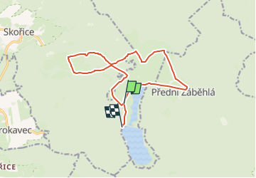
Randonnée A pied de 13,3 km à découvrir à Jihozápad, Plzeňský kraj, Strašice. Cette randonnée est proposée par SityTrail - itinéraires balisés pédestres.
Description
Randonnée créée par Vojenské lesy a statky ČR.
Localisation
Pays :
République Tchèque
Région :
Jihozápad
Département/Province :
Plzeňský kraj
Commune :
Strašice
Localité :
Unknown
Départ:(Dec)
Départ:(UTM)
410222 ; 5501032 (33U) N.
Commentaires
Randonnées à proximité
![Randonnée A pied Strašice - [Č] Obecnice -Mišov - Photo](https://media.geolcdn.com/t/375/260/e4f8ab1a-681d-4bf3-8056-1f08151308ff.jpeg&format=jpg&maxdim=2)
![A pied A pied](https://static1.geolcdn.com/sitytour/trail-icons/100.png)
[Č] Obecnice -Mišov
A pied
Moyen
Strašice,
Jihozápad,
Plzeňský kraj,
République Tchèque
![](/images/other/stat-length.png)
20 km | 27 km-effort
6h 2min
![](https://static1.geolcdn.com/siteimages/upload/files/16400158638029165_repeat_loop_refresh_sync_direction_icon.png)
Non
![Randonnée A pied Borovno - CZ-6738 - Photo](https://media.geolcdn.com/t/375/260/767d9bea-975c-4c40-a228-b9b766707864.jpeg&format=jpg&maxdim=2)
![A pied A pied](https://static1.geolcdn.com/sitytour/trail-icons/100.png)
CZ-6738
A pied
Facile
Borovno,
Jihozápad,
Plzeňský kraj,
République Tchèque
![](/images/other/stat-length.png)
5,1 km | 7,8 km-effort
1h 46min
![](https://static1.geolcdn.com/siteimages/upload/files/16400158638029165_repeat_loop_refresh_sync_direction_icon.png)
Non
![Randonnée A pied Strašice - [Ž] U sv. Jana - Praha - Tři trubky - Photo](https://media.geolcdn.com/t/375/260/286b2410-801c-492c-9dfc-d2ea09783a86.jpeg&format=jpg&maxdim=2)
![A pied A pied](https://static1.geolcdn.com/sitytour/trail-icons/100.png)
[Ž] U sv. Jana - Praha - Tři trubky
A pied
Facile
Strašice,
Jihozápad,
Plzeňský kraj,
République Tchèque
![](/images/other/stat-length.png)
7 km | 10,1 km-effort
2h 17min
![](https://static1.geolcdn.com/siteimages/upload/files/16400158638029165_repeat_loop_refresh_sync_direction_icon.png)
Non
![Randonnée A pied Skořice - [M] Hořejší Padrťský rybník - Pod Hubertkou - Photo](https://media.geolcdn.com/t/375/260/f1a830b0-3fac-479b-ba8c-81824d423497.jpeg&format=jpg&maxdim=2)
![A pied A pied](https://static1.geolcdn.com/sitytour/trail-icons/100.png)
[M] Hořejší Padrťský rybník - Pod Hubertkou
A pied
Facile
Skořice,
Jihozápad,
Plzeňský kraj,
République Tchèque
![](/images/other/stat-length.png)
5,2 km | 7,4 km-effort
1h 40min
![](https://static1.geolcdn.com/siteimages/upload/files/16400158638029165_repeat_loop_refresh_sync_direction_icon.png)
Non
![Randonnée A pied Věšín - [Ž] Varta - Třemšín - Photo](https://media.geolcdn.com/t/375/260/f1b092e8-e85a-4488-b770-d743603f9f8f.jpeg&format=jpg&maxdim=2)
![A pied A pied](https://static1.geolcdn.com/sitytour/trail-icons/100.png)
[Ž] Varta - Třemšín
A pied
Facile
Věšín,
Střední Čechy,
Inconnu,
République Tchèque
![](/images/other/stat-length.png)
11 km | 15,4 km-effort
3h 30min
![](https://static1.geolcdn.com/siteimages/upload/files/16400158638029165_repeat_loop_refresh_sync_direction_icon.png)
Non