![](/images/other/stat-length.png)
![Randonnée A pied Borovno - CZ-6738 - Photo](https://media.geolcdn.com/t/1900/400/767d9bea-975c-4c40-a228-b9b766707864.jpeg&format=pjpeg&maxdim=2)
CZ-6738
SityTrail - itinéraires balisés pédestres
Tous les sentiers balisés d’Europe GUIDE+
![Longueur](/images/other/stat-length.png)
Longueur
5,1 km
![Altitude max](https://static1.geolcdn.com/siteimages/upload/files/1508320355ic_sort_altitude_max_24dp.png)
Altitude max
805 m
![Dénivelé positif](https://static1.geolcdn.com/siteimages/upload/files/1508320355ic_sort_den_pos_24dp.png)
Dénivelé positif
262 m
![Km-Effort](/images/other/stat-length.png)
Km-Effort
7,8 km
![Altitude min](https://static1.geolcdn.com/siteimages/upload/files/1508320355ic_sort_altitude_min_24dp.png)
Altitude min
541 m
![Dénivelé négatif](https://static1.geolcdn.com/siteimages/upload/files/1508320355ic_sort_den_neg_24dp.png)
Dénivelé négatif
33 m
![Boucle](https://static1.geolcdn.com/siteimages/upload/files/16400158638029165_repeat_loop_refresh_sync_direction_icon.png)
Boucle
Non
Balise
Date de création :
2025-02-07 19:06:28.146
Dernière modification :
2025-02-07 19:06:28.146
![A pied](https://static1.geolcdn.com/sitytour/trail-icons/100.png)
1h46
Difficulté : Facile
![Scannez ce code QR pour ouvrir la randonnée dans l'application SityTrail](https://capi.geolives.com/qq0zvz2zws4bq2lad0pu/sitytour/trails/4346579/qr.png?size=200)
Application GPS de randonnée GRATUITE
À propos
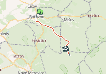
Randonnée A pied de 5,1 km à découvrir à Jihozápad, Plzeňský kraj, Borovno. Cette randonnée est proposée par SityTrail - itinéraires balisés pédestres.
Description
Randonnée créée par cz:KČT.
úsek mezi Maráskem a Borovnem byl přečíslován na trasu
Localisation
Pays :
République Tchèque
Région :
Jihozápad
Département/Province :
Plzeňský kraj
Commune :
Borovno
Localité :
Unknown
Départ:(Dec)
Départ:(UTM)
405354 ; 5497257 (33U) N.
Commentaires
Randonnées à proximité
![Randonnée A pied Strašice - Naučná stezka Okolím Padrťských rybníků - Photo](https://media.geolcdn.com/t/375/260/e147a7f2-eddb-4a26-9a0c-ab5091189530.jpeg&format=jpg&maxdim=2)
![A pied A pied](https://static1.geolcdn.com/sitytour/trail-icons/100.png)
Naučná stezka Okolím Padrťských rybníků
A pied
Facile
Strašice,
Jihozápad,
Plzeňský kraj,
République Tchèque
![](/images/other/stat-length.png)
13,3 km | 16,9 km-effort
3h 50min
![](https://static1.geolcdn.com/siteimages/upload/files/16400158638029165_repeat_loop_refresh_sync_direction_icon.png)
Non
![Randonnée A pied Spálené Poříčí - NS Hvížd'alka - Photo](https://media.geolcdn.com/t/375/260/bb9d9852-610c-4eca-bd54-8cb53828a91c.jpeg&format=jpg&maxdim=2)
![A pied A pied](https://static1.geolcdn.com/sitytour/trail-icons/100.png)
NS Hvížd'alka
A pied
Facile
Spálené Poříčí,
Jihozápad,
Plzeňský kraj,
République Tchèque
![](/images/other/stat-length.png)
3,6 km | 4 km-effort
53min
![](https://static1.geolcdn.com/siteimages/upload/files/16400158638029165_repeat_loop_refresh_sync_direction_icon.png)
Non
![Randonnée A pied Skořice - [M] Hořejší Padrťský rybník - Pod Hubertkou - Photo](https://media.geolcdn.com/t/375/260/f1a830b0-3fac-479b-ba8c-81824d423497.jpeg&format=jpg&maxdim=2)
![A pied A pied](https://static1.geolcdn.com/sitytour/trail-icons/100.png)
[M] Hořejší Padrťský rybník - Pod Hubertkou
A pied
Facile
Skořice,
Jihozápad,
Plzeňský kraj,
République Tchèque
![](/images/other/stat-length.png)
5,2 km | 7,4 km-effort
1h 40min
![](https://static1.geolcdn.com/siteimages/upload/files/16400158638029165_repeat_loop_refresh_sync_direction_icon.png)
Non
![Randonnée A pied Spálené Poříčí - Naučná stezka Za mlynáři od Bradavy - Photo](https://media.geolcdn.com/t/375/260/1f8b1e1d-b3bc-48fe-8f17-f74d4c7d7f46.jpeg&format=jpg&maxdim=2)
![A pied A pied](https://static1.geolcdn.com/sitytour/trail-icons/100.png)
Naučná stezka Za mlynáři od Bradavy
A pied
Facile
Spálené Poříčí,
Jihozápad,
Plzeňský kraj,
République Tchèque
![](/images/other/stat-length.png)
4,5 km | 5 km-effort
1h 8min
![](https://static1.geolcdn.com/siteimages/upload/files/16400158638029165_repeat_loop_refresh_sync_direction_icon.png)
Non