![](/images/other/stat-length.png)
![Randonnée A pied Unknown - Polhill Reserve loop shared way - Photo](https://media.geolcdn.com/t/1900/400/b952bd82-4563-49c0-9b8a-a044e5fd1fb1.jpeg&format=pjpeg&maxdim=2)
Polhill Reserve loop shared way
SityTrail - itinéraires balisés pédestres
Tous les sentiers balisés d’Europe GUIDE+
![Longueur](/images/other/stat-length.png)
Longueur
6,4 km
![Altitude max](https://static1.geolcdn.com/siteimages/upload/files/1508320355ic_sort_altitude_max_24dp.png)
Altitude max
264 m
![Dénivelé positif](https://static1.geolcdn.com/siteimages/upload/files/1508320355ic_sort_den_pos_24dp.png)
Dénivelé positif
210 m
![Km-Effort](/images/other/stat-length.png)
Km-Effort
9,2 km
![Altitude min](https://static1.geolcdn.com/siteimages/upload/files/1508320355ic_sort_altitude_min_24dp.png)
Altitude min
66 m
![Dénivelé négatif](https://static1.geolcdn.com/siteimages/upload/files/1508320355ic_sort_den_neg_24dp.png)
Dénivelé négatif
217 m
![Boucle](https://static1.geolcdn.com/siteimages/upload/files/16400158638029165_repeat_loop_refresh_sync_direction_icon.png)
Boucle
Oui
Balise
Date de création :
2025-02-07 18:48:34.534
Dernière modification :
2025-02-07 18:48:34.534
![A pied](https://static1.geolcdn.com/sitytour/trail-icons/100.png)
2h05
Difficulté : Facile
![Scannez ce code QR pour ouvrir la randonnée dans l'application SityTrail](https://capi.geolives.com/qq0zvz2zws4bq2lad0pu/sitytour/trails/4346556/qr.png?size=200)
Application GPS de randonnée GRATUITE
À propos
Randonnée A pied de 6,4 km à découvrir à Wellington, Wellington City. Cette randonnée est proposée par SityTrail - itinéraires balisés pédestres.
Description
Randonnée créée par Wellington City Council.
Site web: https://wellington.govt.nz/recreation/enjoy-the-outdoors/walks-and-walkways/across-the-city/polhill-reserve-loop
Localisation
Pays :
Nouvelle-Zélande
Région :
Wellington
Département/Province :
Wellington City
Commune :
Unknown
Localité :
Unknown
Départ:(Dec)
Départ:(UTM)
311860 ; 5425789 (60G) S.
Commentaires
Randonnées à proximité
![Randonnée A pied - Southern Walkway - Photo](https://media.geolcdn.com/t/375/260/01b27489-2bc2-4f34-a02b-eca2f1b9ae46.jpeg&format=jpg&maxdim=2)
![A pied A pied](https://static1.geolcdn.com/sitytour/trail-icons/100.png)
Southern Walkway
A pied
Facile
,
Wellington,
Wellington City,
Nouvelle-Zélande
![](/images/other/stat-length.png)
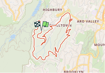
9,9 km | 14,6 km-effort
3h 19min
![](https://static1.geolcdn.com/siteimages/upload/files/16400158638029165_repeat_loop_refresh_sync_direction_icon.png)
Non
![Randonnée A pied - Te Araroa - 06 Wellington - f Lambton Quay, Wellington to Shorland Park, Island Bay - Photo](https://media.geolcdn.com/t/375/260/c027d961-c23f-4cbb-8548-c43eb304f969.jpeg&format=jpg&maxdim=2)
![A pied A pied](https://static1.geolcdn.com/sitytour/trail-icons/100.png)
Te Araroa - 06 Wellington - f Lambton Quay, Wellington to Shorland Park, Isla...
A pied
Facile
,
Wellington,
Wellington City,
Nouvelle-Zélande
![](/images/other/stat-length.png)
13,6 km | 19,1 km-effort
4h 20min
![](https://static1.geolcdn.com/siteimages/upload/files/16400158638029165_repeat_loop_refresh_sync_direction_icon.png)
Non
![Randonnée A pied - City to Sea Walkway - Photo](https://media.geolcdn.com/t/375/260/01b27489-2bc2-4f34-a02b-eca2f1b9ae46.jpeg&format=jpg&maxdim=2)
![A pied A pied](https://static1.geolcdn.com/sitytour/trail-icons/100.png)
City to Sea Walkway
A pied
Moyen
,
Wellington,
Wellington City,
Nouvelle-Zélande
![](/images/other/stat-length.png)
13,9 km | 21 km-effort
4h 43min
![](https://static1.geolcdn.com/siteimages/upload/files/16400158638029165_repeat_loop_refresh_sync_direction_icon.png)
Non
![Randonnée A pied - Hutt Road shared path - Wellington to Petone - Photo](https://media.geolcdn.com/t/375/260/ext.jpg?maxdim=2&url=https%3A%2F%2Fstatic1.geolcdn.com%2Fsiteimages%2Fupload%2Ffiles%2F1545311037marcheuse_200dpi.jpg)
![A pied A pied](https://static1.geolcdn.com/sitytour/trail-icons/100.png)
Hutt Road shared path - Wellington to Petone
A pied
Facile
,
Wellington,
Wellington City,
Nouvelle-Zélande
![](/images/other/stat-length.png)
10,8 km | 12 km-effort
2h 43min
![](https://static1.geolcdn.com/siteimages/upload/files/16400158638029165_repeat_loop_refresh_sync_direction_icon.png)
Non