![](/images/other/stat-length.png)
![Randonnée A pied Unknown - Putem šparuga - Photo](https://media.geolcdn.com/t/1900/400/14bded5a-5ea7-4599-97a9-7c5dfffdfbce.jpeg&format=pjpeg&maxdim=2)
Putem šparuga
SityTrail - itinéraires balisés pédestres
Tous les sentiers balisés d’Europe GUIDE+
![Longueur](/images/other/stat-length.png)
Longueur
5,4 km
![Altitude max](https://static1.geolcdn.com/siteimages/upload/files/1508320355ic_sort_altitude_max_24dp.png)
Altitude max
289 m
![Dénivelé positif](https://static1.geolcdn.com/siteimages/upload/files/1508320355ic_sort_den_pos_24dp.png)
Dénivelé positif
90 m
![Km-Effort](/images/other/stat-length.png)
Km-Effort
6,6 km
![Altitude min](https://static1.geolcdn.com/siteimages/upload/files/1508320355ic_sort_altitude_min_24dp.png)
Altitude min
213 m
![Dénivelé négatif](https://static1.geolcdn.com/siteimages/upload/files/1508320355ic_sort_den_neg_24dp.png)
Dénivelé négatif
105 m
![Boucle](https://static1.geolcdn.com/siteimages/upload/files/16400158638029165_repeat_loop_refresh_sync_direction_icon.png)
Boucle
Oui
Balise
Date de création :
2025-02-07 18:41:15.831
Dernière modification :
2025-02-07 18:41:15.831
![A pied](https://static1.geolcdn.com/sitytour/trail-icons/100.png)
1h30
Difficulté : Facile
![Scannez ce code QR pour ouvrir la randonnée dans l'application SityTrail](https://capi.geolives.com/qq0zvz2zws4bq2lad0pu/sitytour/trails/4346547/qr.png?size=200)
Application GPS de randonnée GRATUITE
À propos
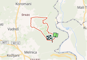
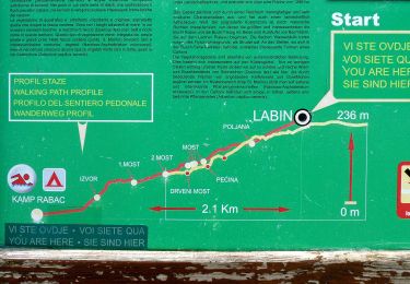
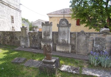
Randonnée A pied de 5,4 km à découvrir à Inconnu, Comitat d'Istrie. Cette randonnée est proposée par SityTrail - itinéraires balisés pédestres.
Description
Randonnée créée par Istra Trails.
Symbole: green bar on yellow ground
Site web: http://www.istria-trails.com/hr/staze/trail-staze/135-ch-0?&l_over=1
Localisation
Pays :
Croatie
Région :
Inconnu
Département/Province :
Comitat d'Istrie
Commune :
Unknown
Localité :
Unknown
Départ:(Dec)
Départ:(UTM)
422650 ; 4991841 (33T) N.
Commentaires
Randonnées à proximité
![Randonnée A pied - Mošćenice-Kremenjak/Brgud - Photo](https://media.geolcdn.com/t/375/260/7fa01776-385e-43c7-9c6c-105b4c56b4e2.jpeg&format=jpg&maxdim=2)
![A pied A pied](https://static1.geolcdn.com/sitytour/trail-icons/100.png)
Mošćenice-Kremenjak/Brgud
A pied
Facile
,
Inconnu,
Comitat de Primorje-Gorski Kotar,
Croatie
![](/images/other/stat-length.png)
4,5 km | 10,5 km-effort
2h 23min
![](https://static1.geolcdn.com/siteimages/upload/files/16400158638029165_repeat_loop_refresh_sync_direction_icon.png)
Non
![Randonnée A pied - Staza svete Barbare (Labin - Kapelica - Raša) - Photo](https://media.geolcdn.com/t/375/260/92d929e7-f9f2-4380-af70-b6952281b5b1.jpeg&format=jpg&maxdim=2)
![A pied A pied](https://static1.geolcdn.com/sitytour/trail-icons/100.png)
Staza svete Barbare (Labin - Kapelica - Raša)
A pied
Facile
,
Inconnu,
Comitat d'Istrie,
Croatie
![](/images/other/stat-length.png)
4,4 km | 5,6 km-effort
1h 15min
![](https://static1.geolcdn.com/siteimages/upload/files/16400158638029165_repeat_loop_refresh_sync_direction_icon.png)
Non
![Randonnée A pied - Šetnica skirivenih čari (Sv.Andrija - Prižnja - Prohaska - Sv.Andrija) - Photo](https://media.geolcdn.com/t/375/260/8a718095-d900-46e8-a808-07aa714c8273.jpeg&format=jpg&maxdim=2)
![A pied A pied](https://static1.geolcdn.com/sitytour/trail-icons/100.png)
Šetnica skirivenih čari (Sv.Andrija - Prižnja - Prohaska - Sv.Andrija)
A pied
Facile
,
Inconnu,
Comitat d'Istrie,
Croatie
![](/images/other/stat-length.png)
4,7 km | 6 km-effort
1h 21min
![](https://static1.geolcdn.com/siteimages/upload/files/16400158638029165_repeat_loop_refresh_sync_direction_icon.png)
Oui
![Randonnée A pied - Staza božanskih izvora (Rabač - Labin) - Photo](https://media.geolcdn.com/t/375/260/d1341b4b-837c-4f20-9975-0875322f3656.jpeg&format=jpg&maxdim=2)
![A pied A pied](https://static1.geolcdn.com/sitytour/trail-icons/100.png)
Staza božanskih izvora (Rabač - Labin)
A pied
Facile
,
Inconnu,
Comitat d'Istrie,
Croatie
![](/images/other/stat-length.png)
3,1 km | 5,9 km-effort
1h 20min
![](https://static1.geolcdn.com/siteimages/upload/files/16400158638029165_repeat_loop_refresh_sync_direction_icon.png)
Non
![Randonnée A pied - Staza Terra Magica (Rabac - Prtlog - Gondolići - Rabač) - Photo](https://media.geolcdn.com/t/375/260/1ca390a2-0a17-4c3a-b8c2-9eb2b26310a8.jpeg&format=jpg&maxdim=2)
![A pied A pied](https://static1.geolcdn.com/sitytour/trail-icons/100.png)
Staza Terra Magica (Rabac - Prtlog - Gondolići - Rabač)
A pied
Facile
,
Inconnu,
Comitat d'Istrie,
Croatie
![](/images/other/stat-length.png)
13,1 km | 18,9 km-effort
4h 17min
![](https://static1.geolcdn.com/siteimages/upload/files/16400158638029165_repeat_loop_refresh_sync_direction_icon.png)
Oui
![Randonnée A pied - Staza Svetog Justa (Labin - Gondolići - Rabač) - Photo](https://media.geolcdn.com/t/375/260/32bec582-10c6-477b-a338-ba39d025a35c.jpeg&format=jpg&maxdim=2)
![A pied A pied](https://static1.geolcdn.com/sitytour/trail-icons/100.png)
Staza Svetog Justa (Labin - Gondolići - Rabač)
A pied
Facile
,
Inconnu,
Comitat d'Istrie,
Croatie
![](/images/other/stat-length.png)
6,4 km | 9 km-effort
2h 2min
![](https://static1.geolcdn.com/siteimages/upload/files/16400158638029165_repeat_loop_refresh_sync_direction_icon.png)
Non
![Randonnée A pied - Sentonina staza (Labin - Rabač) - Photo](https://media.geolcdn.com/t/375/260/f753b171-712f-41e5-af8b-42ac7963ef77.jpeg&format=jpg&maxdim=2)
![A pied A pied](https://static1.geolcdn.com/sitytour/trail-icons/100.png)
Sentonina staza (Labin - Rabač)
A pied
Facile
,
Inconnu,
Comitat d'Istrie,
Croatie
![](/images/other/stat-length.png)
3,2 km | 4,2 km-effort
56min
![](https://static1.geolcdn.com/siteimages/upload/files/16400158638029165_repeat_loop_refresh_sync_direction_icon.png)
Non
![Randonnée A pied - LPP alternative between Skitača and Drenje - Photo](https://media.geolcdn.com/t/375/260/7e0191a0-a5d3-4646-b3cc-9737cd0f3d1b.jpeg&format=jpg&maxdim=2)
![A pied A pied](https://static1.geolcdn.com/sitytour/trail-icons/100.png)
LPP alternative between Skitača and Drenje
A pied
Facile
,
Inconnu,
Comitat d'Istrie,
Croatie
![](/images/other/stat-length.png)
9,9 km | 15 km-effort
3h 24min
![](https://static1.geolcdn.com/siteimages/upload/files/16400158638029165_repeat_loop_refresh_sync_direction_icon.png)
Non
![Randonnée A pied - Staza svetog Šimuna - Photo](https://media.geolcdn.com/t/375/260/970e86b8-4ca0-4fad-bdcc-faa23a3dd662.jpeg&format=jpg&maxdim=2)
![A pied A pied](https://static1.geolcdn.com/sitytour/trail-icons/100.png)
Staza svetog Šimuna
A pied
Facile
,
Inconnu,
Comitat d'Istrie,
Croatie
![](/images/other/stat-length.png)
8,9 km | 14,5 km-effort
3h 18min
![](https://static1.geolcdn.com/siteimages/upload/files/16400158638029165_repeat_loop_refresh_sync_direction_icon.png)
Oui