![](/images/other/stat-length.png)
![Randonnée A pied Unknown - Planetární stezka údolím Vltavy - Photo](https://media.geolcdn.com/t/1900/400/c214e74a-a4b3-4d68-b886-9b530e198029.jpeg&format=pjpeg&maxdim=2)
Planetární stezka údolím Vltavy
SityTrail - itinéraires balisés pédestres
Tous les sentiers balisés d’Europe GUIDE+
![Longueur](/images/other/stat-length.png)
Longueur
12,4 km
![Altitude max](https://static1.geolcdn.com/siteimages/upload/files/1508320355ic_sort_altitude_max_24dp.png)
Altitude max
203 m
![Dénivelé positif](https://static1.geolcdn.com/siteimages/upload/files/1508320355ic_sort_den_pos_24dp.png)
Dénivelé positif
112 m
![Km-Effort](/images/other/stat-length.png)
Km-Effort
13,9 km
![Altitude min](https://static1.geolcdn.com/siteimages/upload/files/1508320355ic_sort_altitude_min_24dp.png)
Altitude min
171 m
![Dénivelé négatif](https://static1.geolcdn.com/siteimages/upload/files/1508320355ic_sort_den_neg_24dp.png)
Dénivelé négatif
117 m
![Boucle](https://static1.geolcdn.com/siteimages/upload/files/16400158638029165_repeat_loop_refresh_sync_direction_icon.png)
Boucle
Non
Balise
Date de création :
2025-02-07 18:23:10.667
Dernière modification :
2025-02-07 18:23:10.667
![A pied](https://static1.geolcdn.com/sitytour/trail-icons/100.png)
3h09
Difficulté : Facile
![Scannez ce code QR pour ouvrir la randonnée dans l'application SityTrail](https://capi.geolives.com/qq0zvz2zws4bq2lad0pu/sitytour/trails/4346512/qr.png?size=200)
Application GPS de randonnée GRATUITE
À propos
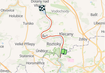
Randonnée A pied de 12,4 km à découvrir à Prague, Prague. Cette randonnée est proposée par SityTrail - itinéraires balisés pédestres.
Description
Randonnée créée par cz:Kosmo Klub, z.s..
Localisation
Pays :
République Tchèque
Région :
Prague
Département/Province :
Prague
Commune :
Unknown
Localité :
Unknown
Départ:(Dec)
Départ:(UTM)
456873 ; 5554305 (33U) N.
Commentaires
Randonnées à proximité
![Randonnée A pied - naučná stezka Roztocký háj – Tiché údolí - Photo](https://media.geolcdn.com/t/375/260/0450cf2b-95b9-4612-922d-5c33e8c65c23.jpeg&format=jpg&maxdim=2)
![A pied A pied](https://static1.geolcdn.com/sitytour/trail-icons/100.png)
naučná stezka Roztocký háj – Tiché údolí
A pied
Facile
,
Prague,
Prague,
République Tchèque
![](/images/other/stat-length.png)
7,2 km | 8,7 km-effort
1h 58min
![](https://static1.geolcdn.com/siteimages/upload/files/16400158638029165_repeat_loop_refresh_sync_direction_icon.png)
Non
![Randonnée A pied - [Z] Čimice - Klecánky - Photo](https://media.geolcdn.com/t/375/260/433c64df-35f1-468b-a70f-736e91c39f2a.jpeg&format=jpg&maxdim=2)
![A pied A pied](https://static1.geolcdn.com/sitytour/trail-icons/100.png)
[Z] Čimice - Klecánky
A pied
Facile
,
Prague,
Prague,
République Tchèque
![](/images/other/stat-length.png)
6,5 km | 8,1 km-effort
1h 50min
![](https://static1.geolcdn.com/siteimages/upload/files/16400158638029165_repeat_loop_refresh_sync_direction_icon.png)
Non
![Randonnée A pied - [Ž] Roztoky - Kobylisy - Photo](https://media.geolcdn.com/t/375/260/3ca52963-cde0-4956-8c8f-1bab9a1b4af1.jpeg&format=jpg&maxdim=2)
![A pied A pied](https://static1.geolcdn.com/sitytour/trail-icons/100.png)
[Ž] Roztoky - Kobylisy
A pied
Facile
,
Prague,
Prague,
République Tchèque
![](/images/other/stat-length.png)
10,9 km | 12,6 km-effort
2h 51min
![](https://static1.geolcdn.com/siteimages/upload/files/16400158638029165_repeat_loop_refresh_sync_direction_icon.png)
Non
![Randonnée A pied Úholičky - [Z] Roztoky - Úholičky - Photo](https://media.geolcdn.com/t/375/260/3ca52963-cde0-4956-8c8f-1bab9a1b4af1.jpeg&format=jpg&maxdim=2)
![A pied A pied](https://static1.geolcdn.com/sitytour/trail-icons/100.png)
[Z] Roztoky - Úholičky
A pied
Facile
Úholičky,
Střední Čechy,
Inconnu,
République Tchèque
![](/images/other/stat-length.png)
8,8 km | 10,8 km-effort
2h 27min
![](https://static1.geolcdn.com/siteimages/upload/files/16400158638029165_repeat_loop_refresh_sync_direction_icon.png)
Non
![Randonnée A pied Roztoky - [Ž] Kamýcká - Roztoky - Photo](https://media.geolcdn.com/t/375/260/3ca52963-cde0-4956-8c8f-1bab9a1b4af1.jpeg&format=jpg&maxdim=2)
![A pied A pied](https://static1.geolcdn.com/sitytour/trail-icons/100.png)
[Ž] Kamýcká - Roztoky
A pied
Facile
Roztoky,
Střední Čechy,
Inconnu,
République Tchèque
![](/images/other/stat-length.png)
4 km | 5 km-effort
1h 8min
![](https://static1.geolcdn.com/siteimages/upload/files/16400158638029165_repeat_loop_refresh_sync_direction_icon.png)
Non
![Randonnée A pied - [Z] Hanspaulka - Únětice - Photo](https://media.geolcdn.com/t/375/260/1f690473-16bc-4587-b194-c05b4e1c7359.jpeg&format=jpg&maxdim=2)
![A pied A pied](https://static1.geolcdn.com/sitytour/trail-icons/100.png)
[Z] Hanspaulka - Únětice
A pied
Facile
,
Prague,
Prague,
République Tchèque
![](/images/other/stat-length.png)
7,7 km | 9,9 km-effort
2h 14min
![](https://static1.geolcdn.com/siteimages/upload/files/16400158638029165_repeat_loop_refresh_sync_direction_icon.png)
Non
![Randonnée A pied - [M] U Matěje - Dolní Šárka - Photo](https://media.geolcdn.com/t/375/260/39142838-5243-45f7-8c53-ff16d677fa0a.jpeg&format=jpg&maxdim=2)
![A pied A pied](https://static1.geolcdn.com/sitytour/trail-icons/100.png)
[M] U Matěje - Dolní Šárka
A pied
Facile
,
Prague,
Prague,
République Tchèque
![](/images/other/stat-length.png)
6,8 km | 9,6 km-effort
2h 11min
![](https://static1.geolcdn.com/siteimages/upload/files/16400158638029165_repeat_loop_refresh_sync_direction_icon.png)
Non
![Randonnée A pied Úholičky - NS Rozhlédni se člověče - Photo](https://media.geolcdn.com/t/375/260/8481291c-1fb9-41a3-b092-153eb7dc4673.jpeg&format=jpg&maxdim=2)
![A pied A pied](https://static1.geolcdn.com/sitytour/trail-icons/100.png)
NS Rozhlédni se člověče
A pied
Facile
Úholičky,
Střední Čechy,
Inconnu,
République Tchèque
![](/images/other/stat-length.png)
4 km | 6,2 km-effort
1h 24min
![](https://static1.geolcdn.com/siteimages/upload/files/16400158638029165_repeat_loop_refresh_sync_direction_icon.png)
Non
![Randonnée Marche - Château Prague - Photo](https://media.geolcdn.com/t/375/260/ext.jpg?maxdim=2&url=https%3A%2F%2Fstatic1.geolcdn.com%2Fsiteimages%2Fupload%2Ffiles%2F1553511878bg_sport_marche.png)
![Marche Marche](https://static1.geolcdn.com/sitytour/trail-icons/101.png)
Château Prague
Marche
Facile
,
Prague,
Prague,
République Tchèque
![](/images/other/stat-length.png)
4,5 km | 5,3 km-effort
2h 47min
![](https://static1.geolcdn.com/siteimages/upload/files/16400158638029165_repeat_loop_refresh_sync_direction_icon.png)
Non