


3,3 km | 5,4 km-effort
![Randonnée A pied Železná Ruda - [Ž] Špičák - Čertovo jezero - Photo](https://media.geolcdn.com/t/1900/400/ee7368cb-a4b6-4b61-a473-0c41d55d848b.jpeg&format=pjpeg&maxdim=2)

Tous les sentiers balisés d’Europe GUIDE+


Application GPS de randonnée GRATUITE
 SityTrail
IGN / Instituts géographiques
SityTrail World
Le monde est à vous
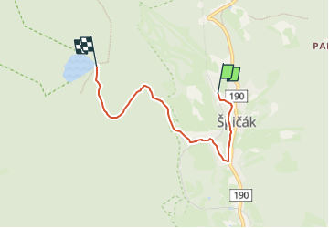
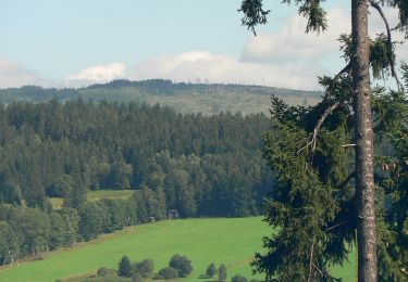
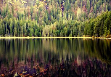
Randonnée A pied de 4,3 km à découvrir à Jihozápad, Plzeňský kraj, Železná Ruda. Cette randonnée est proposée par SityTrail - itinéraires balisés pédestres.
Randonnée créée par cz:KČT.
![Randonnée A pied Železná Ruda - [Ž] Špičák - Čertovo jezero - Photo 1](https://media.geolcdn.com/t/2048/auto/12b959e5-c2a3-4674-856e-0d316ac7e98a.jpeg&format=jpg&maxdim=0 "Randonnée A pied Železná Ruda - [Ž] Špičák - Čertovo jezero - Photo 1")
![Randonnée A pied Železná Ruda - [Ž] Špičák - Čertovo jezero - Photo 2](https://media.geolcdn.com/t/2048/auto/de72aa5e-205a-4259-8fcb-6c7b3595067e.jpeg&format=jpg&maxdim=0 "Randonnée A pied Železná Ruda - [Ž] Špičák - Čertovo jezero - Photo 2")
![Randonnée A pied Železná Ruda - [Ž] Špičák - Čertovo jezero - Photo 3](https://media.geolcdn.com/t/2048/auto/4723e5db-c93a-44b6-b0d7-a25dff6deab0.jpeg&format=jpg&maxdim=0 "Randonnée A pied Železná Ruda - [Ž] Špičák - Čertovo jezero - Photo 3")
![Randonnée A pied Železná Ruda - [Ž] Špičák - Čertovo jezero - Photo 4](https://media.geolcdn.com/t/2048/auto/0bbec1fa-a49c-4bb6-9800-15f3ca7fa347.jpeg&format=jpg&maxdim=0 "Randonnée A pied Železná Ruda - [Ž] Špičák - Čertovo jezero - Photo 4")
![Randonnée A pied Železná Ruda - [Ž] Špičák - Čertovo jezero - Photo 5](https://media.geolcdn.com/t/2048/auto/78c3f782-469e-4e1f-9175-d3d2458c05fe.jpeg&format=jpg&maxdim=0 "Randonnée A pied Železná Ruda - [Ž] Špičák - Čertovo jezero - Photo 5")
![Randonnée A pied Železná Ruda - [Ž] Špičák - Čertovo jezero - Photo 6](https://media.geolcdn.com/t/2048/auto/ca2c0cf0-5f0b-41c5-bf32-eb2acd8edbad.jpeg&format=jpg&maxdim=0 "Randonnée A pied Železná Ruda - [Ž] Špičák - Čertovo jezero - Photo 6")
![Randonnée A pied Železná Ruda - [Ž] Špičák - Čertovo jezero - Photo 7](https://media.geolcdn.com/t/2048/auto/5a1dd436-f578-4366-8b74-aa1ceb072e43.jpeg&format=jpg&maxdim=0 "Randonnée A pied Železná Ruda - [Ž] Špičák - Čertovo jezero - Photo 7")
![Randonnée A pied Železná Ruda - [Ž] Špičák - Čertovo jezero - Photo 8](https://media.geolcdn.com/t/2048/auto/b895a074-c987-4224-b693-300379ac5736.jpeg&format=jpg&maxdim=0 "Randonnée A pied Železná Ruda - [Ž] Špičák - Čertovo jezero - Photo 8")
![Randonnée A pied Železná Ruda - [Ž] Špičák - Čertovo jezero - Photo 9](https://media.geolcdn.com/t/2048/auto/c7a01d93-8fd7-436e-8216-4b64be3db7a2.jpeg&format=jpg&maxdim=0 "Randonnée A pied Železná Ruda - [Ž] Špičák - Čertovo jezero - Photo 9")
![Randonnée A pied Železná Ruda - [Ž] Špičák - Čertovo jezero - Photo 10](https://media.geolcdn.com/t/2048/auto/ee7368cb-a4b6-4b61-a473-0c41d55d848b.jpeg&format=jpg&maxdim=0 "Randonnée A pied Železná Ruda - [Ž] Špičák - Čertovo jezero - Photo 10")
A pied
A pied
![Randonnée A pied Čachrov - [M] Pod Malým Špičákem - Habr - Photo](https://media.geolcdn.com/t/375/260/6d63f79d-11cc-4587-9739-9e93615a4eec.jpeg&format=jpg&maxdim=2)
A pied
A pied
A pied
A pied
A pied
A pied
A pied