Randonnée A pied Unknown - Tršće - Sveta gora - Izvor Kupe - Crni Lug - Photo

Tršće - Sveta gora - Izvor Kupe - Crni Lug

Tous les sentiers balisés d’Europe GUIDE+

© OpenStreetMap contributors
Longueur
Longueur
15,3 km
Altitude max
Altitude max
948 m
Dénivelé positif
Dénivelé positif
525 m
Km-Effort
Km-Effort  
24 km
Altitude min
Altitude min
311 m
Dénivelé négatif
Dénivelé négatif
1012 m
Boucle
Boucle
Non
Balise
Balise
Date de création :
2025-02-07 16:02:45.125
Dernière modification :
2025-02-07 16:02:45.125

(0 Avis)

A pied
A pied
5h25
Difficulté : Moyen

Scannez ce code QR pour ouvrir la randonnée dans l'application SityTrail

Application GPS de randonnée GRATUITE

Logo SityTrail SityTrail

IGN / Instituts géographiques

Télécharger SityTrail sur l'App Store Télécharger SityTrail sur Google Play

Logo SityTrail SityTrail World

Le monde est à vous

Télécharger SityTrail sur l'App Store Télécharger SityTrail sur Google Play Télécharger SityTrail sur Huawei AppGallery

À propos

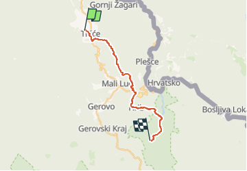
Randonnée A pied de 15,3 km à découvrir à Inconnu, Comitat de Primorje-Gorski Kotar. Cette randonnée est proposée par SityTrail - itinéraires balisés pédestres.

Description

In the area from Tršće to Risnjak National Park, Via Dinarica follows the route of Gorski Kotar Hiking Trail. The trail is well kept and maintained. From Tršće, we first need to climb to the village of Kraljev Vrh by road. From there, we then continue by following the hiking trail markings ...

Site web: https://trail.viadinarica.com/tour/hiking/15948208/

Profil altimétrique

Photos

Localisation

Pays :
Croatie
Région :
Inconnu
Département/Province :
Comitat de Primorje-Gorski Kotar
Commune :
Unknown
Localité :
Unknown
Départ:(UTM)
470662 ; 5046214 (33T) N.

Randonnées à proximité

Randonnée A pied  - Prezid - Čabar - Tršće - Photo
A pied
GUIDE+

A pied

Facile
, Inconnu, Comitat de Primorje-Gorski Kotar, Croatie
4,9 km | 7,1 km-effort
1h 36min
Non


Fermer
Mes abonnements