


16 km | 19,6 km-effort
![Randonnée A pied Ledce - [Z] trojúhelník - Photo](https://media.geolcdn.com/t/1900/400/c688db8e-921c-45c7-bf19-290c8542ad17.jpeg&format=pjpeg&maxdim=2)

Tous les sentiers balisés d’Europe GUIDE+


Application GPS de randonnée GRATUITE
 SityTrail
IGN / Instituts géographiques
SityTrail World
Le monde est à vous
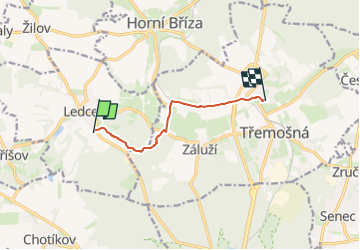
Randonnée A pied de 5,6 km à découvrir à Jihozápad, Plzeňský kraj, Ledce. Cette randonnée est proposée par SityTrail - itinéraires balisés pédestres.
Randonnée créée par cz:KČT.
toto není vrcholová cesta, ale místní trasa značená jen trojůhelníkem bez pozadí
![Randonnée A pied Ledce - [Z] trojúhelník - Photo 1](https://media.geolcdn.com/t/2048/auto/1f85d109-e411-4f97-9089-ca2ac8a90515.jpeg&format=jpg&maxdim=0 "Randonnée A pied Ledce - [Z] trojúhelník - Photo 1")
![Randonnée A pied Ledce - [Z] trojúhelník - Photo 2](https://media.geolcdn.com/t/2048/auto/d6764d71-df11-46bb-bb6c-65c6fbcd1d80.jpeg&format=jpg&maxdim=0 "Randonnée A pied Ledce - [Z] trojúhelník - Photo 2")
![Randonnée A pied Ledce - [Z] trojúhelník - Photo 3](https://media.geolcdn.com/t/2048/auto/427d1e8b-a2cb-4161-af6d-634e697153a4.jpeg&format=jpg&maxdim=0 "Randonnée A pied Ledce - [Z] trojúhelník - Photo 3")
![Randonnée A pied Ledce - [Z] trojúhelník - Photo 4](https://media.geolcdn.com/t/2048/auto/0b55e3d3-8ce4-4ed7-a970-3390789b9263.jpeg&format=jpg&maxdim=0 "Randonnée A pied Ledce - [Z] trojúhelník - Photo 4")
![Randonnée A pied Ledce - [Z] trojúhelník - Photo 5](https://media.geolcdn.com/t/2048/auto/672658cc-9df6-4398-b71d-cf03a49563d7.jpeg&format=jpg&maxdim=0 "Randonnée A pied Ledce - [Z] trojúhelník - Photo 5")
![Randonnée A pied Ledce - [Z] trojúhelník - Photo 6](https://media.geolcdn.com/t/2048/auto/22116cb8-be9d-4517-b1a3-d3a4516063ea.jpeg&format=jpg&maxdim=0 "Randonnée A pied Ledce - [Z] trojúhelník - Photo 6")
![Randonnée A pied Ledce - [Z] trojúhelník - Photo 7](https://media.geolcdn.com/t/2048/auto/1643dbfa-53f7-4997-aea3-208cbbbe7f6d.jpeg&format=jpg&maxdim=0 "Randonnée A pied Ledce - [Z] trojúhelník - Photo 7")
![Randonnée A pied Ledce - [Z] trojúhelník - Photo 8](https://media.geolcdn.com/t/2048/auto/71987b25-ce9d-4800-8ec8-932ba54f4a02.jpeg&format=jpg&maxdim=0 "Randonnée A pied Ledce - [Z] trojúhelník - Photo 8")
![Randonnée A pied Ledce - [Z] trojúhelník - Photo 9](https://media.geolcdn.com/t/2048/auto/d7766ffe-fdf4-435e-93c3-66953251bf2b.jpeg&format=jpg&maxdim=0 "Randonnée A pied Ledce - [Z] trojúhelník - Photo 9")
![Randonnée A pied Ledce - [Z] trojúhelník - Photo 10](https://media.geolcdn.com/t/2048/auto/c688db8e-921c-45c7-bf19-290c8542ad17.jpeg&format=jpg&maxdim=0 "Randonnée A pied Ledce - [Z] trojúhelník - Photo 10")
![Randonnée A pied Třemošná - [Č] Senný dolík - Záluží - Photo](https://media.geolcdn.com/t/375/260/877b0f0e-da18-4148-9dd1-298e2e587c5d.jpeg&format=jpg&maxdim=2)
A pied
A pied
A pied