![](/images/other/stat-length.png)
![Randonnée A pied Mirotice - Alšova NS - Photo](https://media.geolcdn.com/t/1900/400/da37ea90-19db-4587-bfed-638393fede78.jpeg&format=pjpeg&maxdim=2)
Alšova NS
SityTrail - itinéraires balisés pédestres
Tous les sentiers balisés d’Europe GUIDE+
![Longueur](/images/other/stat-length.png)
Longueur
8,3 km
![Altitude max](https://static1.geolcdn.com/siteimages/upload/files/1508320355ic_sort_altitude_max_24dp.png)
Altitude max
578 m
![Dénivelé positif](https://static1.geolcdn.com/siteimages/upload/files/1508320355ic_sort_den_pos_24dp.png)
Dénivelé positif
187 m
![Km-Effort](/images/other/stat-length.png)
Km-Effort
10,8 km
![Altitude min](https://static1.geolcdn.com/siteimages/upload/files/1508320355ic_sort_altitude_min_24dp.png)
Altitude min
412 m
![Dénivelé négatif](https://static1.geolcdn.com/siteimages/upload/files/1508320355ic_sort_den_neg_24dp.png)
Dénivelé négatif
174 m
![Boucle](https://static1.geolcdn.com/siteimages/upload/files/16400158638029165_repeat_loop_refresh_sync_direction_icon.png)
Boucle
Non
Balise
Date de création :
2025-02-07 12:53:40.024
Dernière modification :
2025-02-07 12:53:40.024
![A pied](https://static1.geolcdn.com/sitytour/trail-icons/100.png)
2h26
Difficulté : Facile
![Scannez ce code QR pour ouvrir la randonnée dans l'application SityTrail](https://capi.geolives.com/qq0zvz2zws4bq2lad0pu/sitytour/trails/4345627/qr.png?size=200)
Application GPS de randonnée GRATUITE
À propos
Randonnée A pied de 8,3 km à découvrir à Jihozápad, Jihočeský kraj, Mirotice. Cette randonnée est proposée par SityTrail - itinéraires balisés pédestres.
Description
Randonnée créée par cz:KČT.
Localisation
Pays :
République Tchèque
Région :
Jihozápad
Département/Province :
Jihočeský kraj
Commune :
Mirotice
Localité :
Unknown
Départ:(Dec)
Départ:(UTM)
430180 ; 5476010 (33U) N.
Commentaires
Randonnées à proximité
![Randonnée A pied Albrechtice nad Vltavou - Historická stezka Albrechtickem - Photo](https://media.geolcdn.com/t/375/260/4ec0b7ff-0c97-4fba-b42c-637cce5f02aa.jpeg&format=jpg&maxdim=2)
![A pied A pied](https://static1.geolcdn.com/sitytour/trail-icons/100.png)
Historická stezka Albrechtickem
A pied
Facile
Albrechtice nad Vltavou,
Jihozápad,
Jihočeský kraj,
République Tchèque
![](/images/other/stat-length.png)
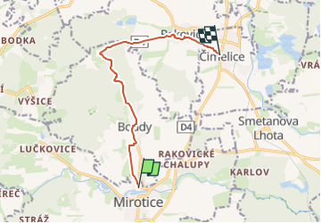
13,5 km | 16,3 km-effort
3h 42min
![](https://static1.geolcdn.com/siteimages/upload/files/16400158638029165_repeat_loop_refresh_sync_direction_icon.png)
Non
![Randonnée A pied Písek - [Č] Písek - Velká Brašna - Photo](https://media.geolcdn.com/t/375/260/bfca88cd-0504-44c2-9a66-8e406f087387.jpeg&format=jpg&maxdim=2)
![A pied A pied](https://static1.geolcdn.com/sitytour/trail-icons/100.png)
[Č] Písek - Velká Brašna
A pied
Facile
Písek,
Jihozápad,
Jihočeský kraj,
République Tchèque
![](/images/other/stat-length.png)
6,3 km | 8,9 km-effort
2h 1min
![](https://static1.geolcdn.com/siteimages/upload/files/16400158638029165_repeat_loop_refresh_sync_direction_icon.png)
Non
![Randonnée A pied Rožmitál pod Třemšínem - [Z] Hutě pod Třemšínem - Břízkovec - Photo](https://media.geolcdn.com/t/375/260/995d403a-75fd-4dbb-a506-7766fe4a4a40.jpeg&format=jpg&maxdim=2)
![A pied A pied](https://static1.geolcdn.com/sitytour/trail-icons/100.png)
[Z] Hutě pod Třemšínem - Břízkovec
A pied
Facile
Rožmitál pod Třemšínem,
Střední Čechy,
Inconnu,
République Tchèque
![](/images/other/stat-length.png)
9 km | 11,8 km-effort
2h 41min
![](https://static1.geolcdn.com/siteimages/upload/files/16400158638029165_repeat_loop_refresh_sync_direction_icon.png)
Non
![Randonnée A pied Písek - NS Od Ptáčkovny k Živci - Photo](https://media.geolcdn.com/t/375/260/cb7dd3a0-b882-4d93-a910-805045955afa.jpeg&format=jpg&maxdim=2)
![A pied A pied](https://static1.geolcdn.com/sitytour/trail-icons/100.png)
NS Od Ptáčkovny k Živci
A pied
Facile
Písek,
Jihozápad,
Jihočeský kraj,
République Tchèque
![](/images/other/stat-length.png)
3,4 km | 5,5 km-effort
1h 15min
![](https://static1.geolcdn.com/siteimages/upload/files/16400158638029165_repeat_loop_refresh_sync_direction_icon.png)
Non
![Randonnée A pied Lety - NS Lety - Photo](https://media.geolcdn.com/t/375/260/d835afd1-38cc-4ff7-be4f-069fcf082a0b.jpeg&format=jpg&maxdim=2)
![A pied A pied](https://static1.geolcdn.com/sitytour/trail-icons/100.png)
NS Lety
A pied
Facile
Lety,
Jihozápad,
Jihočeský kraj,
République Tchèque
![](/images/other/stat-length.png)
3,4 km | 4 km-effort
54min
![](https://static1.geolcdn.com/siteimages/upload/files/16400158638029165_repeat_loop_refresh_sync_direction_icon.png)
Non
![Randonnée A pied Písek - NS Školní polesí - Hůrka - Photo](https://media.geolcdn.com/t/375/260/7133faff-b21d-41b6-9f51-c54858ab31a0.jpeg&format=jpg&maxdim=2)
![A pied A pied](https://static1.geolcdn.com/sitytour/trail-icons/100.png)
NS Školní polesí - Hůrka
A pied
Facile
Písek,
Jihozápad,
Jihočeský kraj,
République Tchèque
![](/images/other/stat-length.png)
9,5 km | 12 km-effort
2h 43min
![](https://static1.geolcdn.com/siteimages/upload/files/16400158638029165_repeat_loop_refresh_sync_direction_icon.png)
Oui
![Randonnée A pied Sedlice - [Ž] Láz - Milavy - sedlická obora - Photo](https://media.geolcdn.com/t/375/260/6a91fed6-3737-44c3-9d07-3733ec90ba53.jpeg&format=jpg&maxdim=2)
![A pied A pied](https://static1.geolcdn.com/sitytour/trail-icons/100.png)
[Ž] Láz - Milavy - sedlická obora
A pied
Facile
Sedlice,
Jihozápad,
Jihočeský kraj,
République Tchèque
![](/images/other/stat-length.png)
6,9 km | 8,1 km-effort
1h 50min
![](https://static1.geolcdn.com/siteimages/upload/files/16400158638029165_repeat_loop_refresh_sync_direction_icon.png)
Non
![Randonnée A pied Klučenice - NS Na Onen svět - Photo](https://media.geolcdn.com/t/375/260/938d6664-86a6-4e72-8bb9-65003c811eb3.jpeg&format=jpg&maxdim=2)
![A pied A pied](https://static1.geolcdn.com/sitytour/trail-icons/100.png)
NS Na Onen svět
A pied
Très difficile
Klučenice,
Střední Čechy,
Inconnu,
République Tchèque
![](/images/other/stat-length.png)
68 km | 84 km-effort
19h 10min
![](https://static1.geolcdn.com/siteimages/upload/files/16400158638029165_repeat_loop_refresh_sync_direction_icon.png)
Non
![Randonnée A pied Kovářov - NS Kovářovsko - Photo](https://media.geolcdn.com/t/375/260/e7885aa2-0be1-469f-9484-9c1bc3936290.jpeg&format=jpg&maxdim=2)
![A pied A pied](https://static1.geolcdn.com/sitytour/trail-icons/100.png)
NS Kovářovsko
A pied
Moyen
Kovářov,
Jihozápad,
Jihočeský kraj,
République Tchèque
![](/images/other/stat-length.png)
19,4 km | 24 km-effort
5h 32min
![](https://static1.geolcdn.com/siteimages/upload/files/16400158638029165_repeat_loop_refresh_sync_direction_icon.png)
Oui