![](/images/other/stat-length.png)
![Randonnée A pied Košátky - NS Byšice - Photo](https://media.geolcdn.com/t/1900/400/9c738d9c-aa7b-4648-9e62-fd68b011a319.jpeg&format=pjpeg&maxdim=2)
NS Byšice
SityTrail - itinéraires balisés pédestres
Tous les sentiers balisés d’Europe GUIDE+
![Longueur](/images/other/stat-length.png)
Longueur
9,1 km
![Altitude max](https://static1.geolcdn.com/siteimages/upload/files/1508320355ic_sort_altitude_max_24dp.png)
Altitude max
236 m
![Dénivelé positif](https://static1.geolcdn.com/siteimages/upload/files/1508320355ic_sort_den_pos_24dp.png)
Dénivelé positif
68 m
![Km-Effort](/images/other/stat-length.png)
Km-Effort
10,1 km
![Altitude min](https://static1.geolcdn.com/siteimages/upload/files/1508320355ic_sort_altitude_min_24dp.png)
Altitude min
182 m
![Dénivelé négatif](https://static1.geolcdn.com/siteimages/upload/files/1508320355ic_sort_den_neg_24dp.png)
Dénivelé négatif
96 m
![Boucle](https://static1.geolcdn.com/siteimages/upload/files/16400158638029165_repeat_loop_refresh_sync_direction_icon.png)
Boucle
Non
Balise
Date de création :
2025-02-07 12:24:59.557
Dernière modification :
2025-02-07 12:24:59.557
![A pied](https://static1.geolcdn.com/sitytour/trail-icons/100.png)
2h17
Difficulté : Facile
![Scannez ce code QR pour ouvrir la randonnée dans l'application SityTrail](https://capi.geolives.com/qq0zvz2zws4bq2lad0pu/sitytour/trails/4345564/qr.png?size=200)
Application GPS de randonnée GRATUITE
À propos
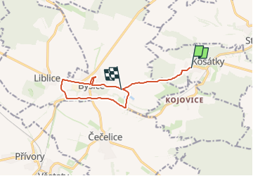
Randonnée A pied de 9,1 km à découvrir à Střední Čechy, Inconnu, Košátky. Cette randonnée est proposée par SityTrail - itinéraires balisés pédestres.
Description
Randonnée créée par cz:KČT.
Localisation
Pays :
République Tchèque
Région :
Střední Čechy
Département/Province :
Inconnu
Commune :
Košátky
Localité :
Unknown
Départ:(Dec)
Départ:(UTM)
475854 ; 5573791 (33U) N.
Commentaires
Randonnées à proximité
![Randonnée A pied Kojetice - [Z] Kojetice - Kostelec nad Labem - Photo](https://media.geolcdn.com/t/375/260/b48711fe-946a-4219-93f6-8a21a39e13c4.jpeg&format=jpg&maxdim=2)
![A pied A pied](https://static1.geolcdn.com/sitytour/trail-icons/100.png)
[Z] Kojetice - Kostelec nad Labem
A pied
Facile
Kojetice,
Střední Čechy,
Inconnu,
République Tchèque
![](/images/other/stat-length.png)
10,1 km | 11 km-effort
2h 29min
![](https://static1.geolcdn.com/siteimages/upload/files/16400158638029165_repeat_loop_refresh_sync_direction_icon.png)
Non
![Randonnée A pied Štětí - NS Loupežníka Štětky - Photo](https://media.geolcdn.com/t/375/260/51ee37d2-ab1d-4d8a-8573-145cb4c1f798.jpeg&format=jpg&maxdim=2)
![A pied A pied](https://static1.geolcdn.com/sitytour/trail-icons/100.png)
NS Loupežníka Štětky
A pied
Facile
Štětí,
Severozápad,
Ústecký kraj,
République Tchèque
![](/images/other/stat-length.png)
3,8 km | 4,2 km-effort
57min
![](https://static1.geolcdn.com/siteimages/upload/files/16400158638029165_repeat_loop_refresh_sync_direction_icon.png)
Non
![Randonnée A pied - Planetární stezka údolím Vltavy - Photo](https://media.geolcdn.com/t/375/260/c214e74a-a4b3-4d68-b886-9b530e198029.jpeg&format=jpg&maxdim=2)
![A pied A pied](https://static1.geolcdn.com/sitytour/trail-icons/100.png)
Planetární stezka údolím Vltavy
A pied
Facile
,
Prague,
Prague,
République Tchèque
![](/images/other/stat-length.png)
12,4 km | 13,9 km-effort
3h 9min
![](https://static1.geolcdn.com/siteimages/upload/files/16400158638029165_repeat_loop_refresh_sync_direction_icon.png)
Non
![Randonnée A pied Nepřevázka - NS PP Chlum - Photo](https://media.geolcdn.com/t/375/260/d4c5be34-3834-4ac2-829f-9a826c7dc87a.jpeg&format=jpg&maxdim=2)
![A pied A pied](https://static1.geolcdn.com/sitytour/trail-icons/100.png)
NS PP Chlum
A pied
Facile
Nepřevázka,
Střední Čechy,
Inconnu,
République Tchèque
![](/images/other/stat-length.png)
7,3 km | 9,7 km-effort
2h 12min
![](https://static1.geolcdn.com/siteimages/upload/files/16400158638029165_repeat_loop_refresh_sync_direction_icon.png)
Non
![Randonnée A pied Bělá pod Bezdězem - NS Březinské studánky - Photo](https://media.geolcdn.com/t/375/260/d631307e-373d-4417-a2d6-191b26017c78.jpeg&format=jpg&maxdim=2)
![A pied A pied](https://static1.geolcdn.com/sitytour/trail-icons/100.png)
NS Březinské studánky
A pied
Facile
Bělá pod Bezdězem,
Střední Čechy,
Inconnu,
République Tchèque
![](/images/other/stat-length.png)
7,1 km | 8,5 km-effort
1h 56min
![](https://static1.geolcdn.com/siteimages/upload/files/16400158638029165_repeat_loop_refresh_sync_direction_icon.png)
Non
![Randonnée A pied Lužec nad Vltavou - NS Vrbno - Zelčín - Photo](https://media.geolcdn.com/t/375/260/a4f12d6e-dea1-4167-a16c-ed0264928862.jpeg&format=jpg&maxdim=2)
![A pied A pied](https://static1.geolcdn.com/sitytour/trail-icons/100.png)
NS Vrbno - Zelčín
A pied
Facile
Lužec nad Vltavou,
Střední Čechy,
Inconnu,
République Tchèque
![](/images/other/stat-length.png)
3,5 km | 3,7 km-effort
50min
![](https://static1.geolcdn.com/siteimages/upload/files/16400158638029165_repeat_loop_refresh_sync_direction_icon.png)
Non
![Randonnée A pied Sudovo Hlavno - NS Vladyky Sudy - Photo](https://media.geolcdn.com/t/375/260/ea93aa69-51f4-4456-b462-fef77f0b99b9.jpeg&format=jpg&maxdim=2)
![A pied A pied](https://static1.geolcdn.com/sitytour/trail-icons/100.png)
NS Vladyky Sudy
A pied
Facile
Sudovo Hlavno,
Střední Čechy,
Inconnu,
République Tchèque
![](/images/other/stat-length.png)
3,2 km | 3,4 km-effort
46min
![](https://static1.geolcdn.com/siteimages/upload/files/16400158638029165_repeat_loop_refresh_sync_direction_icon.png)
Oui
![Randonnée A pied Štětí - NS Loupežníka Štětky - Photo](https://media.geolcdn.com/t/375/260/d50d668e-4b12-43e6-8074-ee6f74d1a7c6.jpeg&format=jpg&maxdim=2)
![A pied A pied](https://static1.geolcdn.com/sitytour/trail-icons/100.png)
NS Loupežníka Štětky
A pied
Difficile
Štětí,
Severozápad,
Ústecký kraj,
République Tchèque
![](/images/other/stat-length.png)
28 km | 33 km-effort
7h 34min
![](https://static1.geolcdn.com/siteimages/upload/files/16400158638029165_repeat_loop_refresh_sync_direction_icon.png)
Oui
![Randonnée A pied Liblice - [Ž] Kolo - Dolní Habarsko - Photo](https://media.geolcdn.com/t/375/260/34020c7d-306d-40a8-abb1-e13e79f8c1cd.jpeg&format=jpg&maxdim=2)
![A pied A pied](https://static1.geolcdn.com/sitytour/trail-icons/100.png)
[Ž] Kolo - Dolní Habarsko
A pied
Facile
Liblice,
Střední Čechy,
Inconnu,
République Tchèque
![](/images/other/stat-length.png)
4,4 km | 5,2 km-effort
1h 11min
![](https://static1.geolcdn.com/siteimages/upload/files/16400158638029165_repeat_loop_refresh_sync_direction_icon.png)
Non