![](/images/other/stat-length.png)
![Randonnée A pied Unknown - Grgosova špilja - Slani dol - Photo](https://media.geolcdn.com/t/1900/400/e1d74823-4105-4a56-acd7-4a4d2d506da5.jpeg&format=pjpeg&maxdim=2)
Grgosova špilja - Slani dol
SityTrail - itinéraires balisés pédestres
Tous les sentiers balisés d’Europe GUIDE+
![Longueur](/images/other/stat-length.png)
Longueur
6,9 km
![Altitude max](https://static1.geolcdn.com/siteimages/upload/files/1508320355ic_sort_altitude_max_24dp.png)
Altitude max
483 m
![Dénivelé positif](https://static1.geolcdn.com/siteimages/upload/files/1508320355ic_sort_den_pos_24dp.png)
Dénivelé positif
128 m
![Km-Effort](/images/other/stat-length.png)
Km-Effort
9,4 km
![Altitude min](https://static1.geolcdn.com/siteimages/upload/files/1508320355ic_sort_altitude_min_24dp.png)
Altitude min
236 m
![Dénivelé négatif](https://static1.geolcdn.com/siteimages/upload/files/1508320355ic_sort_den_neg_24dp.png)
Dénivelé négatif
360 m
![Boucle](https://static1.geolcdn.com/siteimages/upload/files/16400158638029165_repeat_loop_refresh_sync_direction_icon.png)
Boucle
Non
Balise
Date de création :
2025-02-07 10:42:12.748
Dernière modification :
2025-02-07 10:42:12.748
![A pied](https://static1.geolcdn.com/sitytour/trail-icons/100.png)
2h07
Difficulté : Facile
![Scannez ce code QR pour ouvrir la randonnée dans l'application SityTrail](https://capi.geolives.com/qq0zvz2zws4bq2lad0pu/sitytour/trails/4345321/qr.png?size=200)
Application GPS de randonnée GRATUITE
À propos
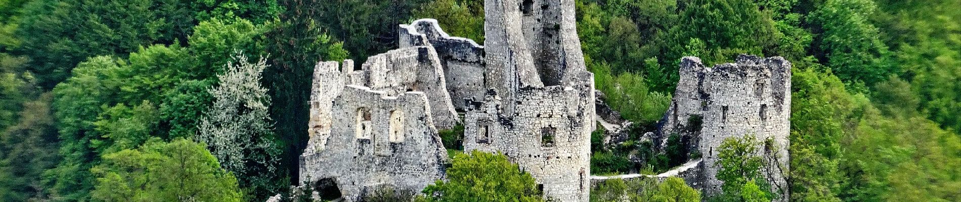
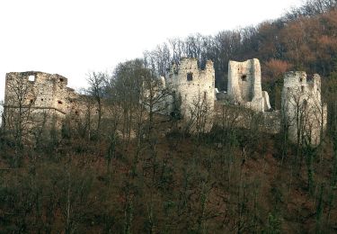
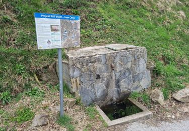
Randonnée A pied de 6,9 km à découvrir à Inconnu, Comitat de Zagreb. Cette randonnée est proposée par SityTrail - itinéraires balisés pédestres.
Description
Randonnée créée par HPD Japetić, Samobor.
Grgosova špilja u Otruševcu (a.p.) - Lešće- Vratnik - Slani Dol (a.p.) - (X) s 42
Localisation
Pays :
Croatie
Région :
Inconnu
Département/Province :
Comitat de Zagreb
Commune :
Unknown
Localité :
Unknown
Départ:(Dec)
Départ:(UTM)
549346 ; 5071020 (33T) N.
Commentaires
Randonnées à proximité
![Randonnée A pied - Osredek - Beder - Photo](https://media.geolcdn.com/t/375/260/02f74ee7-f7a8-4cd6-a4f4-99b06a677f3c.jpeg&format=jpg&maxdim=2)
![A pied A pied](https://static1.geolcdn.com/sitytour/trail-icons/100.png)
Osredek - Beder
A pied
Facile
,
Inconnu,
Comitat de Zagreb,
Croatie
![](/images/other/stat-length.png)
6,4 km | 10,9 km-effort
2h 28min
![](https://static1.geolcdn.com/siteimages/upload/files/16400158638029165_repeat_loop_refresh_sync_direction_icon.png)
Non
![Randonnée A pied - Grdanjci - Noršić selo - Photo](https://media.geolcdn.com/t/375/260/360e921b-97d3-4b67-9f69-dac3c02b0938.jpeg&format=jpg&maxdim=2)
![A pied A pied](https://static1.geolcdn.com/sitytour/trail-icons/100.png)
Grdanjci - Noršić selo
A pied
Facile
,
Inconnu,
Comitat de Zagreb,
Croatie
![](/images/other/stat-length.png)
7,1 km | 9,8 km-effort
2h 13min
![](https://static1.geolcdn.com/siteimages/upload/files/16400158638029165_repeat_loop_refresh_sync_direction_icon.png)
Non
![Randonnée A pied - Noršić Selo - Katin krč - Photo](https://media.geolcdn.com/t/375/260/b167355c-57af-49c1-ae87-931613543d0f.jpeg&format=jpg&maxdim=2)
![A pied A pied](https://static1.geolcdn.com/sitytour/trail-icons/100.png)
Noršić Selo - Katin krč
A pied
Facile
,
Inconnu,
Comitat de Zagreb,
Croatie
![](/images/other/stat-length.png)
5,9 km | 9,5 km-effort
2h 9min
![](https://static1.geolcdn.com/siteimages/upload/files/16400158638029165_repeat_loop_refresh_sync_direction_icon.png)
Non
![Randonnée A pied - Slani dol - Noršić Selo - Photo](https://media.geolcdn.com/t/375/260/360e921b-97d3-4b67-9f69-dac3c02b0938.jpeg&format=jpg&maxdim=2)
![A pied A pied](https://static1.geolcdn.com/sitytour/trail-icons/100.png)
Slani dol - Noršić Selo
A pied
Facile
,
Inconnu,
Comitat de Zagreb,
Croatie
![](/images/other/stat-length.png)
6,6 km | 10,4 km-effort
2h 22min
![](https://static1.geolcdn.com/siteimages/upload/files/16400158638029165_repeat_loop_refresh_sync_direction_icon.png)
Non
![Randonnée A pied - Slani dol - Gostinjac Sv. Bernard - Photo](https://media.geolcdn.com/t/375/260/c97b8dc0-0e3a-4e26-bef6-8556ac70acf5.jpeg&format=jpg&maxdim=2)
![A pied A pied](https://static1.geolcdn.com/sitytour/trail-icons/100.png)
Slani dol - Gostinjac Sv. Bernard
A pied
Facile
,
Inconnu,
Comitat de Zagreb,
Croatie
![](/images/other/stat-length.png)
4,3 km | 6,2 km-effort
1h 24min
![](https://static1.geolcdn.com/siteimages/upload/files/16400158638029165_repeat_loop_refresh_sync_direction_icon.png)
Non
![Randonnée A pied Samobor - Samobor (Hamor) - Slani dol - Photo](https://media.geolcdn.com/t/375/260/287cd65b-9650-4adb-ad52-53091d2e9f31.jpeg&format=jpg&maxdim=2)
![A pied A pied](https://static1.geolcdn.com/sitytour/trail-icons/100.png)
Samobor (Hamor) - Slani dol
A pied
Facile
Samobor,
Inconnu,
Comitat de Zagreb,
Croatie
![](/images/other/stat-length.png)
4,5 km | 7,8 km-effort
1h 46min
![](https://static1.geolcdn.com/siteimages/upload/files/16400158638029165_repeat_loop_refresh_sync_direction_icon.png)
Non
![Randonnée A pied - Rude - Plešivica - Photo](https://media.geolcdn.com/t/375/260/64d55e2e-dd75-4144-9e92-e25a189ac92c.jpeg&format=jpg&maxdim=2)
![A pied A pied](https://static1.geolcdn.com/sitytour/trail-icons/100.png)
Rude - Plešivica
A pied
Facile
,
Inconnu,
Comitat de Zagreb,
Croatie
![](/images/other/stat-length.png)
3,8 km | 8,4 km-effort
1h 53min
![](https://static1.geolcdn.com/siteimages/upload/files/16400158638029165_repeat_loop_refresh_sync_direction_icon.png)
Non
![Randonnée A pied - Šoićeva kuća - Japetić - Photo](https://media.geolcdn.com/t/375/260/b167355c-57af-49c1-ae87-931613543d0f.jpeg&format=jpg&maxdim=2)
![A pied A pied](https://static1.geolcdn.com/sitytour/trail-icons/100.png)
Šoićeva kuća - Japetić
A pied
Facile
,
Inconnu,
Comitat de Zagreb,
Croatie
![](/images/other/stat-length.png)
4,4 km | 6 km-effort
1h 21min
![](https://static1.geolcdn.com/siteimages/upload/files/16400158638029165_repeat_loop_refresh_sync_direction_icon.png)
Non
![Randonnée A pied - Dragonoš - Zečak - Photo](https://media.geolcdn.com/t/375/260/c97b8dc0-0e3a-4e26-bef6-8556ac70acf5.jpeg&format=jpg&maxdim=2)
![A pied A pied](https://static1.geolcdn.com/sitytour/trail-icons/100.png)
Dragonoš - Zečak
A pied
Facile
,
Inconnu,
Comitat de Zagreb,
Croatie
![](/images/other/stat-length.png)
4,9 km | 7,9 km-effort
1h 47min
![](https://static1.geolcdn.com/siteimages/upload/files/16400158638029165_repeat_loop_refresh_sync_direction_icon.png)
Non