![](/images/other/stat-length.png)
![Randonnée A pied Unknown - Sv. Martin - Okić - Photo](https://media.geolcdn.com/t/1900/400/7c2964af-cb21-4dd5-adc5-50608cfeb479.jpeg&format=pjpeg&maxdim=2)
Sv. Martin - Okić
SityTrail - itinéraires balisés pédestres
Tous les sentiers balisés d’Europe GUIDE+
![Longueur](/images/other/stat-length.png)
Longueur
3,5 km
![Altitude max](https://static1.geolcdn.com/siteimages/upload/files/1508320355ic_sort_altitude_max_24dp.png)
Altitude max
411 m
![Dénivelé positif](https://static1.geolcdn.com/siteimages/upload/files/1508320355ic_sort_den_pos_24dp.png)
Dénivelé positif
250 m
![Km-Effort](/images/other/stat-length.png)
Km-Effort
6,1 km
![Altitude min](https://static1.geolcdn.com/siteimages/upload/files/1508320355ic_sort_altitude_min_24dp.png)
Altitude min
177 m
![Dénivelé négatif](https://static1.geolcdn.com/siteimages/upload/files/1508320355ic_sort_den_neg_24dp.png)
Dénivelé négatif
22 m
![Boucle](https://static1.geolcdn.com/siteimages/upload/files/16400158638029165_repeat_loop_refresh_sync_direction_icon.png)
Boucle
Non
Balise
Date de création :
2025-02-07 10:41:08.761
Dernière modification :
2025-02-07 10:41:08.761
![A pied](https://static1.geolcdn.com/sitytour/trail-icons/100.png)
1h22
Difficulté : Facile
![Scannez ce code QR pour ouvrir la randonnée dans l'application SityTrail](https://capi.geolives.com/qq0zvz2zws4bq2lad0pu/sitytour/trails/4345315/qr.png?size=200)
Application GPS de randonnée GRATUITE
À propos
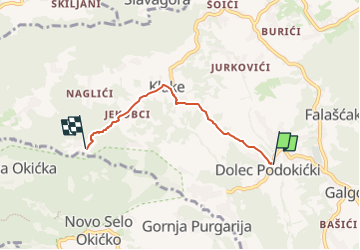
Randonnée A pied de 3,5 km à découvrir à Inconnu, Comitat de Zagreb. Cette randonnée est proposée par SityTrail - itinéraires balisés pédestres.
Description
Randonnée créée par HPD Kapela, Zagreb.
Sv. Martin (a.p.) - Mihina staza - Podiščak - Klake (a.p.) - Jakopci (Etno kuća) - Pl. dom pod Okićem
Localisation
Pays :
Croatie
Région :
Inconnu
Département/Province :
Comitat de Zagreb
Commune :
Unknown
Localité :
Unknown
Départ:(Dec)
Départ:(UTM)
557194 ; 5066211 (33T) N.
Commentaires
Randonnées à proximité
![Randonnée A pied - Rude - Plešivica - Photo](https://media.geolcdn.com/t/375/260/64d55e2e-dd75-4144-9e92-e25a189ac92c.jpeg&format=jpg&maxdim=2)
![A pied A pied](https://static1.geolcdn.com/sitytour/trail-icons/100.png)
Rude - Plešivica
A pied
Facile
,
Inconnu,
Comitat de Zagreb,
Croatie
![](/images/other/stat-length.png)
3,8 km | 8,4 km-effort
1h 53min
![](https://static1.geolcdn.com/siteimages/upload/files/16400158638029165_repeat_loop_refresh_sync_direction_icon.png)
Non
![Randonnée A pied - Galgovo - Okić - Photo](https://media.geolcdn.com/t/375/260/02b13133-b05b-42c7-9042-0684cb5ca176.jpeg&format=jpg&maxdim=2)
![A pied A pied](https://static1.geolcdn.com/sitytour/trail-icons/100.png)
Galgovo - Okić
A pied
Facile
,
Inconnu,
Comitat de Zagreb,
Croatie
![](/images/other/stat-length.png)
4,2 km | 6 km-effort
1h 21min
![](https://static1.geolcdn.com/siteimages/upload/files/16400158638029165_repeat_loop_refresh_sync_direction_icon.png)
Non
![Randonnée A pied - Popovdol - Plešivica - Photo](https://media.geolcdn.com/t/375/260/0eff10e0-d497-4979-a243-eff869dff092.jpeg&format=jpg&maxdim=2)
![A pied A pied](https://static1.geolcdn.com/sitytour/trail-icons/100.png)
Popovdol - Plešivica
A pied
Facile
,
Inconnu,
Comitat de Zagreb,
Croatie
![](/images/other/stat-length.png)
3,2 km | 7,6 km-effort
1h 43min
![](https://static1.geolcdn.com/siteimages/upload/files/16400158638029165_repeat_loop_refresh_sync_direction_icon.png)
Non
![Randonnée A pied Svetonedeljski Breg - Stepinčev put 5. etapa - Photo](https://media.geolcdn.com/t/375/260/29db60e5-e299-4503-a6f4-cfe86e766c98.jpeg&format=jpg&maxdim=2)
![A pied A pied](https://static1.geolcdn.com/sitytour/trail-icons/100.png)
Stepinčev put 5. etapa
A pied
Facile
Svetonedeljski Breg,
Inconnu,
Comitat de Zagreb,
Croatie
![](/images/other/stat-length.png)
8 km | 9,1 km-effort
2h 3min
![](https://static1.geolcdn.com/siteimages/upload/files/16400158638029165_repeat_loop_refresh_sync_direction_icon.png)
Non