![](/images/other/stat-length.png)
![Randonnée A pied Božice - NS Údolím lásky - Photo](https://media.geolcdn.com/t/1900/400/33569034-0db8-4d72-a0e8-ffb991a038f9.jpeg&format=pjpeg&maxdim=2)
NS Údolím lásky
SityTrail - itinéraires balisés pédestres
Tous les sentiers balisés d’Europe GUIDE+
![Longueur](/images/other/stat-length.png)
Longueur
3,8 km
![Altitude max](https://static1.geolcdn.com/siteimages/upload/files/1508320355ic_sort_altitude_max_24dp.png)
Altitude max
219 m
![Dénivelé positif](https://static1.geolcdn.com/siteimages/upload/files/1508320355ic_sort_den_pos_24dp.png)
Dénivelé positif
29 m
![Km-Effort](/images/other/stat-length.png)
Km-Effort
4,2 km
![Altitude min](https://static1.geolcdn.com/siteimages/upload/files/1508320355ic_sort_altitude_min_24dp.png)
Altitude min
205 m
![Dénivelé négatif](https://static1.geolcdn.com/siteimages/upload/files/1508320355ic_sort_den_neg_24dp.png)
Dénivelé négatif
32 m
![Boucle](https://static1.geolcdn.com/siteimages/upload/files/16400158638029165_repeat_loop_refresh_sync_direction_icon.png)
Boucle
Non
Balise
Date de création :
2025-02-07 10:02:03.237
Dernière modification :
2025-02-07 10:02:03.237
![A pied](https://static1.geolcdn.com/sitytour/trail-icons/100.png)
56m
Difficulté : Facile
![Scannez ce code QR pour ouvrir la randonnée dans l'application SityTrail](https://capi.geolives.com/qq0zvz2zws4bq2lad0pu/sitytour/trails/4345162/qr.png?size=200)
Application GPS de randonnée GRATUITE
À propos
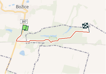
Randonnée A pied de 3,8 km à découvrir à Jihovýchod, Moravie du Sud, Božice. Cette randonnée est proposée par SityTrail - itinéraires balisés pédestres.
Description
Randonnée créée par cz:KČT.
Symbole: green:white:green_bar
Localisation
Pays :
République Tchèque
Région :
Jihovýchod
Département/Province :
Moravie du Sud
Commune :
Božice
Localité :
Unknown
Départ:(Dec)
Départ:(UTM)
594561 ; 5408938 (33U) N.
Commentaires
Randonnées à proximité
![Randonnée A pied Mikulovice - NS moravského včelařství - Photo](https://media.geolcdn.com/t/375/260/aecb43d3-b381-46bc-996f-8597bd3a76e0.jpeg&format=jpg&maxdim=2)
![A pied A pied](https://static1.geolcdn.com/sitytour/trail-icons/100.png)
NS moravského včelařství
A pied
Facile
Mikulovice,
Jihovýchod,
Moravie du Sud,
République Tchèque
![](/images/other/stat-length.png)
4,1 km | 4,9 km-effort
1h 6min
![](https://static1.geolcdn.com/siteimages/upload/files/16400158638029165_repeat_loop_refresh_sync_direction_icon.png)
Oui
![Randonnée A pied Miroslav - Okruh Miroslavské kopce - Photo](https://media.geolcdn.com/t/375/260/3221cc3c-a9f3-4f28-880f-beaad17e940f.jpeg&format=jpg&maxdim=2)
![A pied A pied](https://static1.geolcdn.com/sitytour/trail-icons/100.png)
Okruh Miroslavské kopce
A pied
Facile
Miroslav,
Jihovýchod,
Moravie du Sud,
République Tchèque
![](/images/other/stat-length.png)
4,4 km | 5,7 km-effort
1h 17min
![](https://static1.geolcdn.com/siteimages/upload/files/16400158638029165_repeat_loop_refresh_sync_direction_icon.png)
Oui
![Randonnée A pied Šatov - NS Za historií, vínem a opevněním - Photo](https://media.geolcdn.com/t/375/260/55b44c17-a805-4f4d-b8d8-eedf73749f9a.jpeg&format=jpg&maxdim=2)
![A pied A pied](https://static1.geolcdn.com/sitytour/trail-icons/100.png)
NS Za historií, vínem a opevněním
A pied
Facile
Šatov,
Jihovýchod,
Moravie du Sud,
République Tchèque
![](/images/other/stat-length.png)
3,1 km | 3,6 km-effort
48min
![](https://static1.geolcdn.com/siteimages/upload/files/16400158638029165_repeat_loop_refresh_sync_direction_icon.png)
Oui
![Randonnée A pied Lesonice - Lesonická školní naučná stezka - Photo](https://media.geolcdn.com/t/375/260/b285cb7a-55e5-4a04-996b-db6be9f92a12.jpeg&format=jpg&maxdim=2)
![A pied A pied](https://static1.geolcdn.com/sitytour/trail-icons/100.png)
Lesonická školní naučná stezka
A pied
Facile
Lesonice,
Jihovýchod,
Moravie du Sud,
République Tchèque
![](/images/other/stat-length.png)
3,7 km | 4,8 km-effort
1h 5min
![](https://static1.geolcdn.com/siteimages/upload/files/16400158638029165_repeat_loop_refresh_sync_direction_icon.png)
Oui
![Randonnée A pied Znojmo - [Č] Vranov - Železné schody - Photo](https://media.geolcdn.com/t/375/260/ca9151e2-7333-4e44-883d-767759caa06c.jpeg&format=jpg&maxdim=2)
![A pied A pied](https://static1.geolcdn.com/sitytour/trail-icons/100.png)
[Č] Vranov - Železné schody
A pied
Difficile
Znojmo,
Jihovýchod,
Moravie du Sud,
République Tchèque
![](/images/other/stat-length.png)
30 km | 40 km-effort
9h 10min
![](https://static1.geolcdn.com/siteimages/upload/files/16400158638029165_repeat_loop_refresh_sync_direction_icon.png)
Non
![Randonnée A pied Gemeinde Seefeld-Kadolz - Seefeld-Kadolz: Vier-Jahreszeiten-Weg - Photo](https://media.geolcdn.com/t/375/260/998ef14d-dbff-4ecc-aea2-60b03fc19272.jpeg&format=jpg&maxdim=2)
![A pied A pied](https://static1.geolcdn.com/sitytour/trail-icons/100.png)
Seefeld-Kadolz: Vier-Jahreszeiten-Weg
A pied
Facile
Gemeinde Seefeld-Kadolz,
Basse-Autriche,
Bezirk Hollabrunn,
Autriche
![](/images/other/stat-length.png)
8,9 km | 10,5 km-effort
2h 22min
![](https://static1.geolcdn.com/siteimages/upload/files/16400158638029165_repeat_loop_refresh_sync_direction_icon.png)
Oui
![Randonnée A pied Gemeinde Gaubitsch - Panorama Wanderweg Gaubitsch - Photo](https://media.geolcdn.com/t/375/260/549f18ed-28a7-4acb-a370-be37dba347f5.jpeg&format=jpg&maxdim=2)
![A pied A pied](https://static1.geolcdn.com/sitytour/trail-icons/100.png)
Panorama Wanderweg Gaubitsch
A pied
Facile
Gemeinde Gaubitsch,
Basse-Autriche,
Bezirk Mistelbach,
Autriche
![](/images/other/stat-length.png)
6,2 km | 7,9 km-effort
1h 47min
![](https://static1.geolcdn.com/siteimages/upload/files/16400158638029165_repeat_loop_refresh_sync_direction_icon.png)
Oui
![Randonnée A pied Znojmo - [Z] Granice - Znojmo - Photo](https://media.geolcdn.com/t/375/260/ext.jpg?maxdim=2&url=https%3A%2F%2Fstatic1.geolcdn.com%2Fsiteimages%2Fupload%2Ffiles%2F1545311037marcheuse_200dpi.jpg)
![A pied A pied](https://static1.geolcdn.com/sitytour/trail-icons/100.png)
[Z] Granice - Znojmo
A pied
Facile
Znojmo,
Jihovýchod,
Moravie du Sud,
République Tchèque
![](/images/other/stat-length.png)
8,9 km | 12,7 km-effort
2h 53min
![](https://static1.geolcdn.com/siteimages/upload/files/16400158638029165_repeat_loop_refresh_sync_direction_icon.png)
Non