


10,1 km | 11 km-effort
![Randonnée A pied Liblice - [Ž] Kolo - Dolní Habarsko - Photo](https://media.geolcdn.com/t/1900/400/34020c7d-306d-40a8-abb1-e13e79f8c1cd.jpeg&format=pjpeg&maxdim=2)

Tous les sentiers balisés d’Europe GUIDE+


Application GPS de randonnée GRATUITE
 SityTrail
IGN / Instituts géographiques
SityTrail World
Le monde est à vous
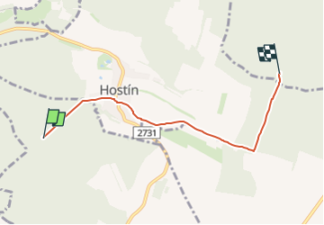
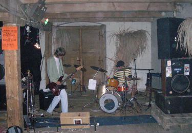
Randonnée A pied de 4,4 km à découvrir à Střední Čechy, Inconnu, Liblice. Cette randonnée est proposée par SityTrail - itinéraires balisés pédestres.
Randonnée créée par cz:KČT.
![Randonnée A pied Liblice - [Ž] Kolo - Dolní Habarsko - Photo 1](https://media.geolcdn.com/t/2048/auto/8aebacb1-5075-4e9c-bd8b-73413b2bdc2c.jpeg&format=jpg&maxdim=0 "Randonnée A pied Liblice - [Ž] Kolo - Dolní Habarsko - Photo 1")
![Randonnée A pied Liblice - [Ž] Kolo - Dolní Habarsko - Photo 2](https://media.geolcdn.com/t/2048/auto/9b7937ed-f4ea-4bc7-a54b-1908a4da5497.jpeg&format=jpg&maxdim=0 "Randonnée A pied Liblice - [Ž] Kolo - Dolní Habarsko - Photo 2")
![Randonnée A pied Liblice - [Ž] Kolo - Dolní Habarsko - Photo 3](https://media.geolcdn.com/t/2048/auto/6831f84d-9733-4523-b2fd-c49e5b56d800.jpeg&format=jpg&maxdim=0 "Randonnée A pied Liblice - [Ž] Kolo - Dolní Habarsko - Photo 3")
![Randonnée A pied Liblice - [Ž] Kolo - Dolní Habarsko - Photo 4](https://media.geolcdn.com/t/2048/auto/c1f53e2b-be76-49f0-8396-14b7eec97391.jpeg&format=jpg&maxdim=0 "Randonnée A pied Liblice - [Ž] Kolo - Dolní Habarsko - Photo 4")
![Randonnée A pied Liblice - [Ž] Kolo - Dolní Habarsko - Photo 5](https://media.geolcdn.com/t/2048/auto/e0fd2e45-983f-4e38-aaf0-53f4867a45ff.jpeg&format=jpg&maxdim=0 "Randonnée A pied Liblice - [Ž] Kolo - Dolní Habarsko - Photo 5")
![Randonnée A pied Liblice - [Ž] Kolo - Dolní Habarsko - Photo 6](https://media.geolcdn.com/t/2048/auto/39d82d3a-b829-466b-9de1-2c8d309ba56d.jpeg&format=jpg&maxdim=0 "Randonnée A pied Liblice - [Ž] Kolo - Dolní Habarsko - Photo 6")
![Randonnée A pied Liblice - [Ž] Kolo - Dolní Habarsko - Photo 7](https://media.geolcdn.com/t/2048/auto/c8710fe9-523e-4bca-a942-6a207706b34d.jpeg&format=jpg&maxdim=0 "Randonnée A pied Liblice - [Ž] Kolo - Dolní Habarsko - Photo 7")
![Randonnée A pied Liblice - [Ž] Kolo - Dolní Habarsko - Photo 8](https://media.geolcdn.com/t/2048/auto/d4d75d8c-2b2f-423b-b185-a7a0a67abd50.jpeg&format=jpg&maxdim=0 "Randonnée A pied Liblice - [Ž] Kolo - Dolní Habarsko - Photo 8")
![Randonnée A pied Liblice - [Ž] Kolo - Dolní Habarsko - Photo 9](https://media.geolcdn.com/t/2048/auto/26863559-5685-46ec-a197-0d34f6873004.jpeg&format=jpg&maxdim=0 "Randonnée A pied Liblice - [Ž] Kolo - Dolní Habarsko - Photo 9")
![Randonnée A pied Liblice - [Ž] Kolo - Dolní Habarsko - Photo 10](https://media.geolcdn.com/t/2048/auto/34020c7d-306d-40a8-abb1-e13e79f8c1cd.jpeg&format=jpg&maxdim=0 "Randonnée A pied Liblice - [Ž] Kolo - Dolní Habarsko - Photo 10")
![Randonnée A pied Kojetice - [Z] Kojetice - Kostelec nad Labem - Photo](https://media.geolcdn.com/t/375/260/b48711fe-946a-4219-93f6-8a21a39e13c4.jpeg&format=jpg&maxdim=2)
A pied
A pied
A pied
A pied
A pied
A pied
A pied
![Randonnée A pied Chorušice - [M] Mělnická Vrutice - Zahájí - Photo](https://media.geolcdn.com/t/375/260/5bbe73f2-35ef-41ee-977d-f53953a5ded4.jpeg&format=jpg&maxdim=2)
A pied
![Randonnée A pied Skorkov - [Z] Stará Boleslav - Sojovice - Photo](https://media.geolcdn.com/t/375/260/81add56f-4755-44e5-95ad-2b8fa91098ef.jpeg&format=jpg&maxdim=2)
A pied