


3,4 km | 4 km-effort
![Randonnée A pied Lesná - [Z] naučná stezka historie sklářství - Photo](https://media.geolcdn.com/t/1900/400/4bc902d5-239d-46bc-9e59-dc21d99fa2b6.jpeg&format=pjpeg&maxdim=2)

Tous les sentiers balisés d’Europe GUIDE+


Application GPS de randonnée GRATUITE
 SityTrail
IGN / Instituts géographiques
SityTrail World
Le monde est à vous
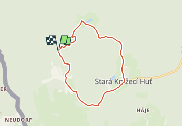
Randonnée A pied de 6,3 km à découvrir à Jihozápad, Plzeňský kraj, Lesná. Cette randonnée est proposée par SityTrail - itinéraires balisés pédestres.
Randonnée créée par cz:KČT.
značena standardní zelenou
![Randonnée A pied Lesná - [Z] naučná stezka historie sklářství - Photo 1](https://media.geolcdn.com/t/2048/auto/cf5ed792-a100-4bc9-8c91-25c3ddf82c85.jpeg&format=jpg&maxdim=0 "Randonnée A pied Lesná - [Z] naučná stezka historie sklářství - Photo 1")
![Randonnée A pied Lesná - [Z] naučná stezka historie sklářství - Photo 2](https://media.geolcdn.com/t/2048/auto/c20c2960-b46a-49bb-be48-2cee05dc913b.jpeg&format=jpg&maxdim=0 "Randonnée A pied Lesná - [Z] naučná stezka historie sklářství - Photo 2")
![Randonnée A pied Lesná - [Z] naučná stezka historie sklářství - Photo 3](https://media.geolcdn.com/t/2048/auto/947c166b-89cd-439f-a07d-7291707f21eb.jpeg&format=jpg&maxdim=0 "Randonnée A pied Lesná - [Z] naučná stezka historie sklářství - Photo 3")
![Randonnée A pied Lesná - [Z] naučná stezka historie sklářství - Photo 4](https://media.geolcdn.com/t/2048/auto/111b443a-ce0b-406d-952a-8ccacb18341a.jpeg&format=jpg&maxdim=0 "Randonnée A pied Lesná - [Z] naučná stezka historie sklářství - Photo 4")
![Randonnée A pied Lesná - [Z] naučná stezka historie sklářství - Photo 5](https://media.geolcdn.com/t/2048/auto/1ca430fd-db46-4760-a11c-ad9ff60c426a.jpeg&format=jpg&maxdim=0 "Randonnée A pied Lesná - [Z] naučná stezka historie sklářství - Photo 5")
![Randonnée A pied Lesná - [Z] naučná stezka historie sklářství - Photo 6](https://media.geolcdn.com/t/2048/auto/59b4fa46-2e91-4006-ab5c-0870caca33d6.jpeg&format=jpg&maxdim=0 "Randonnée A pied Lesná - [Z] naučná stezka historie sklářství - Photo 6")
![Randonnée A pied Lesná - [Z] naučná stezka historie sklářství - Photo 7](https://media.geolcdn.com/t/2048/auto/74f75ae6-8ec5-4813-9063-1fdbd0920d5d.jpeg&format=jpg&maxdim=0 "Randonnée A pied Lesná - [Z] naučná stezka historie sklářství - Photo 7")
![Randonnée A pied Lesná - [Z] naučná stezka historie sklářství - Photo 8](https://media.geolcdn.com/t/2048/auto/ddf842f6-8f73-4396-92d5-5152ac474b67.jpeg&format=jpg&maxdim=0 "Randonnée A pied Lesná - [Z] naučná stezka historie sklářství - Photo 8")
![Randonnée A pied Lesná - [Z] naučná stezka historie sklářství - Photo 9](https://media.geolcdn.com/t/2048/auto/c1356457-c15d-4518-a3bb-d5ce91d9ba3d.jpeg&format=jpg&maxdim=0 "Randonnée A pied Lesná - [Z] naučná stezka historie sklářství - Photo 9")
![Randonnée A pied Lesná - [Z] naučná stezka historie sklářství - Photo 10](https://media.geolcdn.com/t/2048/auto/4bc902d5-239d-46bc-9e59-dc21d99fa2b6.jpeg&format=jpg&maxdim=0 "Randonnée A pied Lesná - [Z] naučná stezka historie sklářství - Photo 10")
A pied
A pied
A pied

A pied