![](/images/other/stat-length.png)
![Randonnée A pied Unknown - Draga - Žitnica - Photo](https://media.geolcdn.com/t/1900/400/c97b8dc0-0e3a-4e26-bef6-8556ac70acf5.jpeg&format=pjpeg&maxdim=2)
Draga - Žitnica
SityTrail - itinéraires balisés pédestres
Tous les sentiers balisés d’Europe GUIDE+
![Longueur](/images/other/stat-length.png)
Longueur
4 km
![Altitude max](https://static1.geolcdn.com/siteimages/upload/files/1508320355ic_sort_altitude_max_24dp.png)
Altitude max
817 m
![Dénivelé positif](https://static1.geolcdn.com/siteimages/upload/files/1508320355ic_sort_den_pos_24dp.png)
Dénivelé positif
46 m
![Km-Effort](/images/other/stat-length.png)
Km-Effort
6 km
![Altitude min](https://static1.geolcdn.com/siteimages/upload/files/1508320355ic_sort_altitude_min_24dp.png)
Altitude min
392 m
![Dénivelé négatif](https://static1.geolcdn.com/siteimages/upload/files/1508320355ic_sort_den_neg_24dp.png)
Dénivelé négatif
465 m
![Boucle](https://static1.geolcdn.com/siteimages/upload/files/16400158638029165_repeat_loop_refresh_sync_direction_icon.png)
Boucle
Non
Balise
Date de création :
2025-02-07 08:22:47.124
Dernière modification :
2025-02-07 08:22:47.124
![A pied](https://static1.geolcdn.com/sitytour/trail-icons/100.png)
1h21
Difficulté : Facile
![Scannez ce code QR pour ouvrir la randonnée dans l'application SityTrail](https://capi.geolives.com/qq0zvz2zws4bq2lad0pu/sitytour/trails/4344940/qr.png?size=200)
Application GPS de randonnée GRATUITE
À propos
Randonnée A pied de 4 km à découvrir à Inconnu, Comitat de Zagreb. Cette randonnée est proposée par SityTrail - itinéraires balisés pédestres.
Description
Randonnée créée par HPD Jastrebarsko, Jastrebarsko.
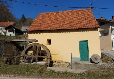
Višoševićev mlin u Dragi - Grabarak - Pl. dom Žitnica na Japetiću
Localisation
Pays :
Croatie
Région :
Inconnu
Département/Province :
Comitat de Zagreb
Commune :
Unknown
Localité :
Unknown
Départ:(Dec)
Départ:(UTM)
546959 ; 5065474 (33T) N.
Commentaires
Randonnées à proximité
![Randonnée A pied - Slani dol - Gostinjac Sv. Bernard - Photo](https://media.geolcdn.com/t/375/260/c97b8dc0-0e3a-4e26-bef6-8556ac70acf5.jpeg&format=jpg&maxdim=2)
![A pied A pied](https://static1.geolcdn.com/sitytour/trail-icons/100.png)
Slani dol - Gostinjac Sv. Bernard
A pied
Facile
,
Inconnu,
Comitat de Zagreb,
Croatie
![](/images/other/stat-length.png)
4,3 km | 6,2 km-effort
1h 24min
![](https://static1.geolcdn.com/siteimages/upload/files/16400158638029165_repeat_loop_refresh_sync_direction_icon.png)
Non
![Randonnée A pied - Gornje Rude - Poljanice - Photo](https://media.geolcdn.com/t/375/260/ecb25a92-c337-42e7-952b-54cc173d0117.jpeg&format=jpg&maxdim=2)
![A pied A pied](https://static1.geolcdn.com/sitytour/trail-icons/100.png)
Gornje Rude - Poljanice
A pied
Facile
,
Inconnu,
Comitat de Zagreb,
Croatie
![](/images/other/stat-length.png)
3,7 km | 4,7 km-effort
1h 4min
![](https://static1.geolcdn.com/siteimages/upload/files/16400158638029165_repeat_loop_refresh_sync_direction_icon.png)
Non
![Randonnée A pied - Šoićeva kuća - Japetić - Photo](https://media.geolcdn.com/t/375/260/b167355c-57af-49c1-ae87-931613543d0f.jpeg&format=jpg&maxdim=2)
![A pied A pied](https://static1.geolcdn.com/sitytour/trail-icons/100.png)
Šoićeva kuća - Japetić
A pied
Facile
,
Inconnu,
Comitat de Zagreb,
Croatie
![](/images/other/stat-length.png)
4,4 km | 6 km-effort
1h 21min
![](https://static1.geolcdn.com/siteimages/upload/files/16400158638029165_repeat_loop_refresh_sync_direction_icon.png)
Non
![Randonnée A pied - Dragonoš - Zečak - Photo](https://media.geolcdn.com/t/375/260/c97b8dc0-0e3a-4e26-bef6-8556ac70acf5.jpeg&format=jpg&maxdim=2)
![A pied A pied](https://static1.geolcdn.com/sitytour/trail-icons/100.png)
Dragonoš - Zečak
A pied
Facile
,
Inconnu,
Comitat de Zagreb,
Croatie
![](/images/other/stat-length.png)
4,9 km | 7,9 km-effort
1h 47min
![](https://static1.geolcdn.com/siteimages/upload/files/16400158638029165_repeat_loop_refresh_sync_direction_icon.png)
Non
![Randonnée A pied - Šoićeva kuća - Sv. Bernard - Photo](https://media.geolcdn.com/t/375/260/c97b8dc0-0e3a-4e26-bef6-8556ac70acf5.jpeg&format=jpg&maxdim=2)
![A pied A pied](https://static1.geolcdn.com/sitytour/trail-icons/100.png)
Šoićeva kuća - Sv. Bernard
A pied
Facile
,
Inconnu,
Comitat de Zagreb,
Croatie
![](/images/other/stat-length.png)
3,4 km | 5,7 km-effort
1h 17min
![](https://static1.geolcdn.com/siteimages/upload/files/16400158638029165_repeat_loop_refresh_sync_direction_icon.png)
Non
![Randonnée A pied - Stepinčev put 4. etapa - Photo](https://media.geolcdn.com/t/375/260/0eff10e0-d497-4979-a243-eff869dff092.jpeg&format=jpg&maxdim=2)
![A pied A pied](https://static1.geolcdn.com/sitytour/trail-icons/100.png)
Stepinčev put 4. etapa
A pied
Facile
,
Inconnu,
Comitat de Zagreb,
Croatie
![](/images/other/stat-length.png)
5,9 km | 8,5 km-effort
1h 55min
![](https://static1.geolcdn.com/siteimages/upload/files/16400158638029165_repeat_loop_refresh_sync_direction_icon.png)
Non
![Randonnée A pied - Stepinčev put 3. etapa - Photo](https://media.geolcdn.com/t/375/260/1bbdb2be-a83a-461c-9011-8fe51b583294.jpeg&format=jpg&maxdim=2)
![A pied A pied](https://static1.geolcdn.com/sitytour/trail-icons/100.png)
Stepinčev put 3. etapa
A pied
Facile
,
Inconnu,
Comitat de Zagreb,
Croatie
![](/images/other/stat-length.png)
6,7 km | 9,9 km-effort
2h 14min
![](https://static1.geolcdn.com/siteimages/upload/files/16400158638029165_repeat_loop_refresh_sync_direction_icon.png)
Non
![Randonnée A pied - Prekrižje - Oštrc - Photo](https://media.geolcdn.com/t/375/260/21b94185-510f-4546-991c-c62af1c7bf3f.jpeg&format=jpg&maxdim=2)
![A pied A pied](https://static1.geolcdn.com/sitytour/trail-icons/100.png)
Prekrižje - Oštrc
A pied
Facile
,
Inconnu,
Comitat de Zagreb,
Croatie
![](/images/other/stat-length.png)
3,7 km | 6,5 km-effort
1h 28min
![](https://static1.geolcdn.com/siteimages/upload/files/16400158638029165_repeat_loop_refresh_sync_direction_icon.png)
Non
![Randonnée A pied - Slavetić - Tihočaj - Photo](https://media.geolcdn.com/t/375/260/ext.jpg?maxdim=2&url=https%3A%2F%2Fstatic1.geolcdn.com%2Fsiteimages%2Fupload%2Ffiles%2F1545311037marcheuse_200dpi.jpg)
![A pied A pied](https://static1.geolcdn.com/sitytour/trail-icons/100.png)
Slavetić - Tihočaj
A pied
Facile
,
Inconnu,
Comitat de Zagreb,
Croatie
![](/images/other/stat-length.png)
6,3 km | 11,2 km-effort
2h 32min
![](https://static1.geolcdn.com/siteimages/upload/files/16400158638029165_repeat_loop_refresh_sync_direction_icon.png)
Non