


6,1 km | 8,7 km-effort
![Randonnée A pied Pelhřimov - [Č] Pelhřimov - Nový Rychnov - Photo](https://media.geolcdn.com/t/1900/400/3b527b44-da93-45e2-822d-496afe7c79e4.jpeg&format=pjpeg&maxdim=2)

Tous les sentiers balisés d’Europe GUIDE+


Application GPS de randonnée GRATUITE
 SityTrail
IGN / Instituts géographiques
SityTrail World
Le monde est à vous
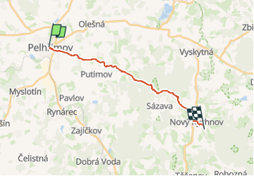
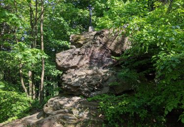
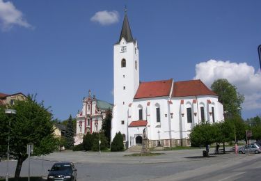
Randonnée A pied de 14,6 km à découvrir à Jihovýchod, Kraj Vysočina, Pelhřimov. Cette randonnée est proposée par SityTrail - itinéraires balisés pédestres.
Randonnée créée par cz:KČT.
![Randonnée A pied Pelhřimov - [Č] Pelhřimov - Nový Rychnov - Photo 1](https://media.geolcdn.com/t/2048/auto/718de0b4-e777-491b-87e1-566ba56f9e28.jpeg&format=jpg&maxdim=0 "Randonnée A pied Pelhřimov - [Č] Pelhřimov - Nový Rychnov - Photo 1")
![Randonnée A pied Pelhřimov - [Č] Pelhřimov - Nový Rychnov - Photo 2](https://media.geolcdn.com/t/2048/auto/693b41ec-4399-4750-a8a9-51c1ba4f5342.jpeg&format=jpg&maxdim=0 "Randonnée A pied Pelhřimov - [Č] Pelhřimov - Nový Rychnov - Photo 2")
![Randonnée A pied Pelhřimov - [Č] Pelhřimov - Nový Rychnov - Photo 3](https://media.geolcdn.com/t/2048/auto/c1b86808-e9f7-43b3-9c9a-377b5f8b4a95.jpeg&format=jpg&maxdim=0 "Randonnée A pied Pelhřimov - [Č] Pelhřimov - Nový Rychnov - Photo 3")
![Randonnée A pied Pelhřimov - [Č] Pelhřimov - Nový Rychnov - Photo 4](https://media.geolcdn.com/t/2048/auto/d5066819-2fe4-4415-a792-eb50cf974e3d.jpeg&format=jpg&maxdim=0 "Randonnée A pied Pelhřimov - [Č] Pelhřimov - Nový Rychnov - Photo 4")
![Randonnée A pied Pelhřimov - [Č] Pelhřimov - Nový Rychnov - Photo 5](https://media.geolcdn.com/t/2048/auto/577a456a-f7f7-47bc-a237-31ce50c909b7.jpeg&format=jpg&maxdim=0 "Randonnée A pied Pelhřimov - [Č] Pelhřimov - Nový Rychnov - Photo 5")
![Randonnée A pied Pelhřimov - [Č] Pelhřimov - Nový Rychnov - Photo 6](https://media.geolcdn.com/t/2048/auto/29d4c7b3-ccb6-4a53-9a65-4a7d3da91cbd.jpeg&format=jpg&maxdim=0 "Randonnée A pied Pelhřimov - [Č] Pelhřimov - Nový Rychnov - Photo 6")
![Randonnée A pied Pelhřimov - [Č] Pelhřimov - Nový Rychnov - Photo 7](https://media.geolcdn.com/t/2048/auto/e3b17c65-2568-4294-9bca-17caef3b7191.jpeg&format=jpg&maxdim=0 "Randonnée A pied Pelhřimov - [Č] Pelhřimov - Nový Rychnov - Photo 7")
![Randonnée A pied Pelhřimov - [Č] Pelhřimov - Nový Rychnov - Photo 8](https://media.geolcdn.com/t/2048/auto/43ed4baa-8af1-41fc-94d5-98ee6216759e.jpeg&format=jpg&maxdim=0 "Randonnée A pied Pelhřimov - [Č] Pelhřimov - Nový Rychnov - Photo 8")
![Randonnée A pied Pelhřimov - [Č] Pelhřimov - Nový Rychnov - Photo 9](https://media.geolcdn.com/t/2048/auto/b248a466-772e-48fa-a026-c5af8e0b22ce.jpeg&format=jpg&maxdim=0 "Randonnée A pied Pelhřimov - [Č] Pelhřimov - Nový Rychnov - Photo 9")
![Randonnée A pied Pelhřimov - [Č] Pelhřimov - Nový Rychnov - Photo 10](https://media.geolcdn.com/t/2048/auto/3b527b44-da93-45e2-822d-496afe7c79e4.jpeg&format=jpg&maxdim=0 "Randonnée A pied Pelhřimov - [Č] Pelhřimov - Nový Rychnov - Photo 10")
A pied
A pied
![Randonnée A pied Nový Rychnov - [Z] Křemešnický okruh - Photo](https://media.geolcdn.com/t/375/260/f11d492b-ddb0-4c5d-b682-83aa126fd453.jpeg&format=jpg&maxdim=2)
A pied
![Randonnée A pied Červená Řečice - [Ž] Červená Řečice - Na vyhlídce - Photo](https://media.geolcdn.com/t/375/260/d705b93f-8824-4978-8f66-916e162f23b1.jpeg&format=jpg&maxdim=2)
A pied
![Randonnée A pied Humpolec - [Ž] Na Štůlách - Bysterská silnice - Photo](https://media.geolcdn.com/t/375/260/19fc1b13-afc2-4444-8232-ccf794b2b63e.jpeg&format=jpg&maxdim=2)
A pied
A pied
A pied
A pied
![Randonnée A pied Humpolec - [Ž] Humpolec - Kletečná - Photo](https://media.geolcdn.com/t/375/260/61c79774-ac44-4316-bc7b-59e2527b1d21.jpeg&format=jpg&maxdim=2)
A pied